PIEDMONT PARK, MO Campground Reservation, Info, Images, Map, Directions

PIEDMONT PARK, Missouri Campground Images, Info & Reservations

Directions

From Piedmont, MO, follow Missouri State Highway HH. Travel on Highway HH for 6 miles to the top of the dam. Turn right and follow signs into campground.

Phone

573-223-7777 (CLEARWATER LAKE PROJECT OFFICE) 573-223-4432 (PIEDMONT PARK GATE HOUSE)

Activities

BOATING, CAMPING, SWIMMING SITE

Keywords

PIED,CLEARWATER LAKE,PIEDMONT,PARK ABOVE THE DAM,CLEARWATER LAKE

Related Link(s)

Rec Area Info & Images

Missouri State Road Conditions

Missouri State Tourism

Overview

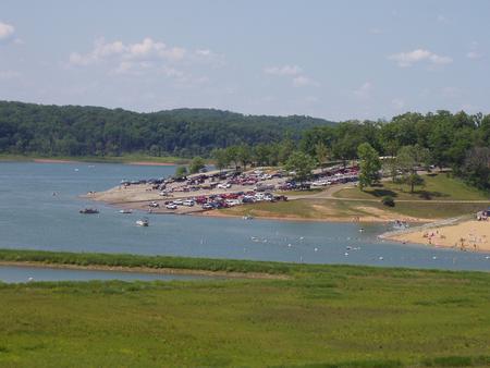
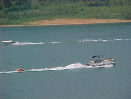
Piedmont Park is a spacious, activity-dense recreation area on the shores of Missouri’s Clearwater Lake. Water sport enthusiasts love the lakes diverse offerings, from boating to jet skiing and canoeing to swimming.

Clearwater is considered a "wilderness lake" because it lacks private boat docks and offers plenty of unspoiled shorelines to explore. The beautiful area is enhanced each spring by flowering shrubs and trees like the redbud, hawthorn, dogwood and wild plum.

Recreation

Wildlife viewing is popular with wetland waterfowl, fox, deer and geese.

Picnicking is also a favorite pastime, as is lounging on the beach, boating and fishing.

Facilities

Piedmont Park Campground offers 97 sites, including many with electric and water hookups. Additional amenities include a dump station, hot showers, picnic shelters, a boat ramp, playgrounds and a swimming area.

Natural Features

Visitors can sit under the shade of a sycamore or maple tree and look out across the lake to the lush but rugged terrain of the Ozark foothills.

The vicinity is noted for the grandeur of its hills, natural springs, and general outdoor beauty. The shoreline is studded with high picturesque bluffs covered with sweet williams, indented bays and quiet coves.

Nearby Attractions

In the area, campers enjoy visiting traditional drive-in movie theaters, the Sam A. Baker State Park, local golf courses, and the historic Civil War site at Fort Benton.

Reservation

More from CampingHiking.net:

LAKE CAMPGROUND, California Campground Images, Info & Reservations

Directions From Wrightwood, turn left on CA-2 W/Angeles Crest Highway and drive for 3.6 miles. Then turn right onto Big Pines Highway and drive 2.7 miles. Look for signs into the campground. Phone 760-249-3526 Activities CAMPING, HIKING Keywords LAKE,ANGELES NF – FS,LAKE,lake,california,Lake at Wrightwood,Lake at Big Pines,Jackson Lake Related Link(s)

BLANCO RIVER GROUP CAMPGROUND, Colorado Campground Images, Info & Reservations

Directions From Pagosa Springs, Colorado, travel 13 miles south on Highway 84, then turn east on Forest Road 656 for approximately two miles. Phone 970-264-2268 Activities CAMPING, FISHING, HIKING Keywords Blanco,Blanco River,Blanc,Blanko Related Link(s) Rec Area Info & Images Forest Service Concessionaire Colorado State Road Conditions Colorado State Tourism Overview

PIGOT BAY CABIN, Alaska Campground Images, Info & Reservations

Directions The cabin is located on the southwest shore near the head of Pigot Bay, northeast of Whittier. Access by a float plane is a 40 minute trip from Anchorage or a 60 minute trip from Cordova. By boat, it is a 18 mile trek from Whittier. Check local tide

COLTON GUARD STATION, Utah Campground Images, Info & Reservations

Directions Follow the mileage indications below and look for signs when traveling to Colton Guard Station. Leave with plenty of time to arrive at the guard station before dark. From Vernal, travel north on U.S. Highway 191/Vernal Avenue for approximately 20 miles. Turn left (west) on Forest Road 020. A

RIVER ROAD PARK, Missouri Campground Images, Info & Reservations

Directions From Piedmont, MO, follow state highway HH for 6 miles. Campground will be located just below Clearwater Lake Dam. Follow signs into campground. Phone 573-223-7777 (CLEARWATER LAKE PROJECT OFFICE) RIVER ROAD PARK GATE HOUSE(573-223-4424 Activities BOATING, CAMPING, FISHING, HIKING, HUNTING, WATER SPORTS, SWIMMING SITE Keywords RILB,CLEARWATER LAKE,RIVER VIEW,BELOW THE

PRAIRIE CREEK (AL), Alabama Campground Images, Info & Reservations

Directions From Montgomery, Alabama, follow Highway 80 west for approximately 25 miles. Turn right on County Road 29 and follow the signs into the campground. Phone 334-418-4919 Activities BIKING, BOATING, CAMPING, FISHING, HIKING, WATER SPORTS, WILDLIFE VIEWING, SWIMMING SITE Keywords PRA1,JONES BLUFF,ALABAMA RIVERS,WOODRUFF,ROBERT F. HENRY,ROBERT F HENRY,ALABAMA RIV. – WO