TUCKER HOLLOW PARK, AR Campground Reservation, Info, Images, Map, Directions

TUCKER HOLLOW PARK, Arkansas Campground Images, Info & Reservations

Listen

Directions

From Lead Hill, AR, travel SR 14 7 mi. NW to SR 281. Travel 3 mi. N on SR 281 and follow signs into campground. Go 7 miles northwest of Lead Hill, AR, on state highway 14, then 3 miles north on state highway 281.

Phone

870-436-5622

Activities

BOATING, CAMPING, SWIMMING SITE

Keywords

TUCK,BULL SHOALS LAKE,BULL SHOALS LAKE

Related Link(s)

Rec Area Info & Images

Arkansas State Road Conditions

Arkansas State Tourism

Overview

Tucker Hollow, a small 28-campsite park, sits near the upper part of Bull Shoals Lake. There’s something for everyone at the region’s most popular lake, whether it’s a day basking in the sun, jet skiing, fishing or canoeing.

Recreation

Bull Shoals Lake beckons water sports lovers, birders, naturalists and those who simply want an escape from the city. Hiking and in-season hunting are popular land activities here.

Facilities

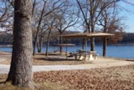
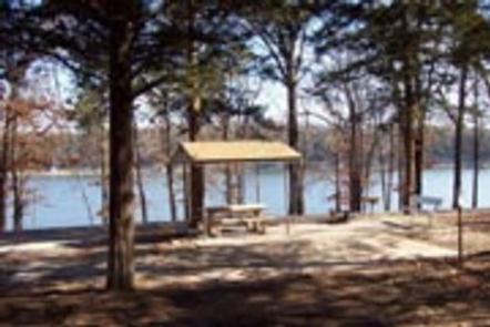
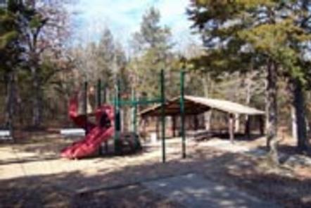
The campsites have electric hookups, and all sites offer 50 amp service. Two picnic shelters are available, but these do not have electricity. Families will enjoy the swimming beach and the playground.

Natural Features

Bull Shoals Lake is located on the northern edge of central Arkansas. Built in 1951 for flood control, the lake spans 71,000 acres and extends for 80 miles. It’s fed by the White River, which flows through the Arkansas Ozarks.

Nearby Attractions

The Bull Shoals-White River State Park has two highly recommended hiking trails to explore. The Big Bluff Trail offers views of the White River below Bull Shoals Dam, and the Lakeside Trail meanders along the shores of the lake.

Reservation

More from CampingHiking.net:

SHELTER BAY CABIN, Alaska Campground Images, Info & Reservations

Listen Directions The cabin is located on the southwest shore of Shelter Bay on Hinchinbrook Island. Access is by floatplane at high tide (20 minutes from Cordova) or wheeled plane at low tide (landing strip located 350 yards north of the cabin). Access by boat is 50 miles from Cordova.

BOY SCOUT, Utah Campground Images, Info & Reservations

Listen Directions From Salt Lake City, head west on I-80 for 36 miles. Take the Stansbury-Tooele/Route 35 exit and travel south 3 miles to Route 138 West. Follow it 10 miles to Grantsville. Go through Grantsville to Cooley Street and turn south; go 5 miles to the South Willow Canyon

BALD MOUNTAIN CAMPGROUND, Wyoming Campground Images, Info & Reservations

Listen Directions From Lovell, Wyoming, take U.S. Highway 14A (not U.S. Highway 14) 33 miles east. The highway has a 10% grade; not recomended for RVs and motorhomes. From Dayton, Wyoming, take U.S. Highway 14/14A west 73 miles via Burgess Junction. This is the recommended route for RVs and motorhomes.

SOFTUK BAR CABIN, Alaska Campground Images, Info & Reservations

Listen Directions Access to the cabin is by wheel plane only at low tide, typically a 25-minute flight from Cordova. Click here for local tide tables. Refer to USGS topographic map Cordova A-2. Phone 1 (907) 424-7661 Activities CAMPING, FISHING, HIKING, HUNTING, WILDLIFE VIEWING Keywords SOF1,CHUGACH NF – FS Related

DEER CREEK, California Campground Images, Info & Reservations

Listen Directions Take Hwy 168 east from Clovis to Shaver Lake. Continue through Shaver Lake to Huntington Lake. Continue around Huntington Lake for 1.2 miles to Deer Creek Campground. Phone 559-893-2111 Activities BOATING, CAMPING, INTERPRETIVE PROGRAMS, FISHING, HIKING, WATER SPORTS, SWIMMING SITE Keywords DEAR,HUNTINGTON LAKE,SIERRA NF – FS Related Link(s)

Burns Lake Campground, Florida Campground Images, Info & Reservations

Listen Directions From Naples: Follow US HWY 41 east until you see signs for campground (approximately mile marker 67). From Miami: Follow US HWY 41 west until you see signs for campground (approximately mile marker 67) Phone 239-695-1205 Activities CAMPING, FISHING Keywords Big Cypress Related Link(s) Rec Area Info &