


Directions
From Sandy, travel Highway 26 for 18 miles to Zigzag. Turn north onto Lolo Pass Road. Continue for about 4 miles, then turn right on Forest Road 1825 and continue for less than a mile. Bear right, staying on Forest Road 1825, and cross the Sandy River Bridge. Continue for another half-mile, to Forest Roads 1825-382. Turn right, cross Lost Creek Bridge, and the campground will be almost immediately on the right.
Phone
503-630-5721
Activities
CAMPING, FISHING, HIKING, HORSEBACK RIDING, VISITOR CENTER
Keywords
RILE,MT. HOOD NF – FS
Related Link(s)
Overview
Riley Campground is an equestrian facility located northwest of Oregon’s majestic Mt. Hood. Horse corrals are tucked into the forest near the campsites, and several horseback riding trails can be accessed from the campground. A variety of recreational and sightseeing opportunities are available for visitors to enjoy.
Recreation
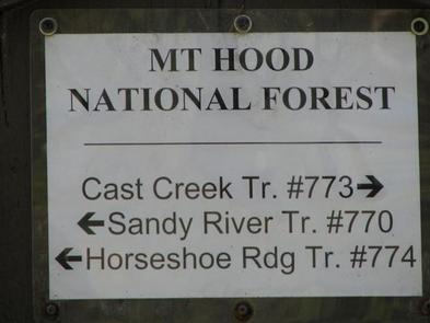
Several hiking, biking and horseback riding trails can be accessed from the campground, including the 5.3-mile Cast Creek Trail, which was reconstructed in 1998 and leads from the campground to the Zigzag Mountain Trail. Combined with the nearby 4.9-mile Horseshoe Ridge Trail and part of the Zigzag Mountain Trail, visitors can make a nearly 14-mile excursion. The Sandy River Trail follows the river and stretches about 3 miles.
Fishing is available in nearby Lost Creek, as well as the Sandy River, which is not far from the campground. Anglers can expect a variety of trout, salmon and whitefish. The rivers are popular for fly fishing. Scenic drives and picnicking are also popular activities.
Facilities
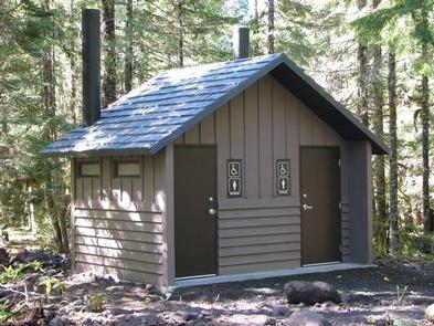
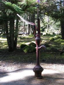
The campground offers single-family equestrian campsites. Most of the sites are equipped with horse corrals or cross rail hitching posts, tables and campfire rings with grills. Accessible vault toilets and drinking water are provided. Horse owners are responsible for cleaning up after their horses.
The campsites are intended for equestrians, but may be used by others. McNeil Campground (1/4 mile away) and Lost Creek (1 �½ miles away) are good alternative sites for those without horses. McNeil does not accept reservations. Horse corrals or hitching racks are provided at the sites.
Natural Features
The campground is situated in the Old Maid Flat geologic area of Mt. Hood National Forest at an elevation of about 2,100 feet. It sits alongside Lost Creek and is near the Sandy Wild and Scenic River. A variety of wildlife makes its home in the area.
Nearby Attractions
A deviation from the road coming into the campground (Forest Road 1825), will lead to a trailhead for spectacular Ramona Falls, on the Sandy River. The 7.1-mile, moderately difficult trail leads to cascading waterfalls and is one of the most popular hikes in Mt. Hood National Forest.