


Directions
The cabin is located on saltwater approximately 30 air miles east of Ketchikan on Winstanley Island on the east side of the Behm Canal between Rudyard and Smeaton Bays. The cabin is accessible by float plane or boat. A mooring buoy is provided at the site. Refer to USGS map Ketchikan B-3. Please consult local tide tables before departing for the cabin.
This cabin is in a designated Wilderness area, and access by helicopter is illegal.
Phone
907-225-2148
Activities
BOATING, CAMPING, FISHING, HIKING, HUNTING, WILDLIFE VIEWING
Keywords
WINS,TONGASS NF – FS
Related Link(s)
Overview
Winstanley Island Cabin is located on Winstanley Island approximately 30 air miles east of Ketchikan. The cabin offers saltwater recreation and wildlife viewing opportunities and makes an excellent base for experiencing this corner of Alaska.
The cabin is remote and accessible only by float plane, boat or kayak, depending on conditions. This primitive cabin has no electricity, indoor plumbing or cell phone coverage. Visitors are responsible for their own travel arrangements and safety, and must bring several of their own amenities.
Recreation
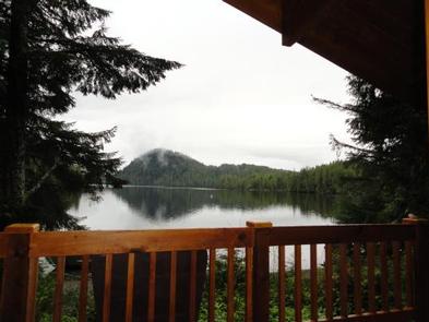
A number of scenic attractions can be reached by boat or kayak from Winstanley Island Cabin, including Walker Cove, Chickamin River, Smeaton Bay, New Eddystone Rock and the Behm Canal. Rudyerd Bay is a good day trip for adventurous sea kayakers. Local tide tables should be consulted before any boating excursion.
Hiking trails to freshwater streams and lakes and various hunting areas are accessible by boat, including Winstanley Lake (#743), Checats (#704), Ella (#70), Manzanita (#721) and Nooya Lake (#724).
Saltwater fishing is possible around the cabin.
Facilities
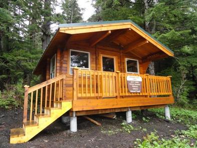
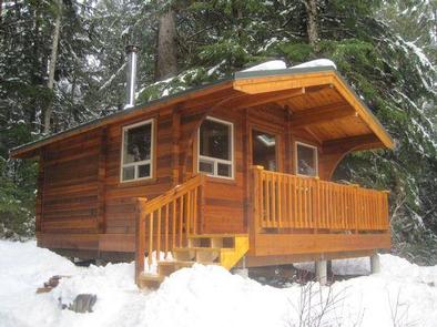
The 12×14-ft. ( pan-abode style ) cabin accommodates up to 6 people with 2 single bunks and 2 double bunks. Other amenities include a table with benches, cooking counter, food storage, broom and dustpan. A wood stove is provided for heat, along with a splitting maul. An outhouse is located nearby. NOTE: Firewood may be available, but visitors are encouraged to contact the Ketchikan Misty Fjords Ranger District to check the status of the woodshed. A mooring buoy is available on a first-come, first-served basis. The cabin reservation does not give exclusive use of the buoy. More than one vessel is allowed to use the buoy if the first party there agrees. Drinking water is not available at the cabin. Visitors should bring their own water supply, but water is also available from a nearby creek and should be treated before drinking or cooking with it (water safety). Visitors should also bring sleeping bags, sleeping pads, cooking gear, lanterns or flashlights, food, toilet paper, garbage bags, a fire extinguisher and fire starter. Rain gear and boots are recommended. Visitors are expected to pack out their trash, gear and food and clean the cabin before leaving (more cabin details).
Natural Features
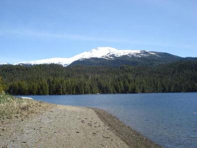
The cabin is located on Shoalwater Pass, which is on the east side of Behm Canal between Rudyerd and Smeaton Bays within the Misty Fiords Monument Wilderness. It is surrounded by rugged mountain peaks and spruce, hemlock and cedar forest.
The Misty Fiords Monument Wilderness supports a diverse variety of wildlife. Mountain goats, bears, moose and bald eagles make their home here (bear safety). The waters host a variety of aquatic mammals, including Dall’s porpoise, orcas, humpback whales, sea otters and harbor seals. Many seabirds can also be seen.