


Directions
Accessible by shallow draft boat and float plane during moderate to high river levels, 18 miles from Wrangell. Low river levels limit small boat access as the Andrews Creek entrance becomes blocked. Tides may affect access; consult local tide tables. A tide of 14 feet or higher is needed for a shallow draft boat to cross the tide flats. The river is normally ice-free May to October. Check local conditions in advance by calling (907) 874-2323.
Phone
907-874-2323
Activities
BOATING, CAMPING, FISHING, HUNTING, WILDLIFE VIEWING, PADDLING, BIRDING
Keywords
MORY,ANDREWS CABIN,CLEARWATER CABIN,TONGASS NF – FS
Related Link(s)
Overview
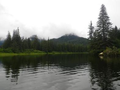
Mount Rynda Cabin is located on Andrews Creek near its confluence with the Stikine River. It is located within the Stikine-LeConte Wilderness and is popular for fishing and paddling. The site can be accessed by float plane or shallow draft boat, depending on conditions. A tide of 14 feet or higher is required to cross the Stikine River tide flats. Guests are responsible for their own travel arrangements and safety, and must bring several of their own amenities.
Recreation
Two miles of slow-moving, clear water near the cabin provide ideal opportunities for canoeing or kayaking up Andrews Creek at river stages over 14 feet. The cabin is often used by paddlers on multi-day float trips of the Stikine River from Telegraph Creek, BC, or the US/Cananda border to the town of Wrangell. Tide charts should be consulted before undertaking any Stikine River expedition. There are excellent fishing opportunities in Andrews Creek for cutthroat trout, Dolly Varden, and king, pink and silver salmon. The area is also popular for bear and moose hunting.
Facilities
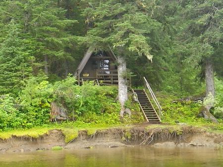
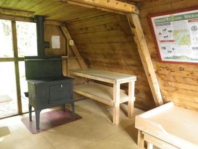
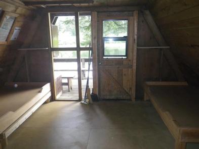
The 16-by-16 cabin (A-frame style) was built in 1963 and has two single bunks (one with a trundle bed) and a sleeping loft, to accommodate up to seven people. It is also equipped with a table with benches, an oil space heater (No.1 oil only), broom and an outhouse. The partially covered front porch has a built-in bench and a bear-proof locker for food storage. Water and electricity are not provided. Water is available from a creek just west of the cabin, but guests should be sure to treat water before drinking or cooking with it ( water safety tips ). It is recommended that guests bring their own water supply. Heating oil is not supplied by the Forest Service. In addition to bringing No.1 stove oil, guests should pack a cook stove, sleeping bags, sleeping pads, lanterns or flashlights, cookware, plates, utensils, food, toilet paper, garbage bags, a fire extinguisher and matches, among other necessities. Guests are expected to pack out trash and clean the cabin before leaving (click here for more cabin details).
Natural Features
The cabin sits on moderately steep land on the riverbank at the base of Mount Rynda. It overlooks the confluence of Andrew Creek and Andrew Slough and is tucked into a forest of primarily Sitka spruce and western hemlock. Gentle to moderate mountain slopes surround the area. Brown and black bears, moose, harbor seals, gulls and bald eagles are frequently seen around the cabin ( bear safety information ). The Stikine River serves as a travel corridor for birds between the interior forests and the coast and attracts a variety of migratory songbirds.