BOYKIN SPRINGS RECREATION AREA, TX Campground Reservation, Info, Images, Map, Directions

BOYKIN SPRINGS RECREATION AREA, Texas Campground Images, Info & Reservations

Listen

Directions

From Zavalla, Texas, travel east on Highway 63 for approximately 10.5 miles. Turn right on Forest Road 313 and proceed 2.5 miles to the campground.

Phone

936-897-1068

Activities

BIKING, CAMPING, FISHING, HIKING, WILDLIFE VIEWING, NON-MOTORIZED BOATING

Keywords

None

Related Link(s)

Rec Area Info & Images

Texas State Road Conditions

Texas State Tourism

Overview

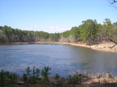
Located on Boykin Springs Lake in Angelina National Forest, this recreation area offers a little of everything, including camping, hiking, fishing, picnicking and relaxing in nature. It is situated in eastern Texas near the Louisiana border.

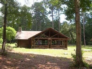
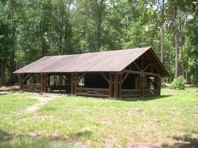
The facility has both a campground and day-use area. The group shelter must be reserved; the campground is first-come, first-served.

Recreation

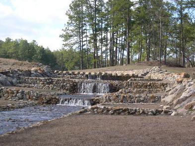
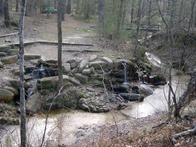
The group picnic area provides direct access to the Sawmill Trail, a hiking trail that winds through the forest to the Aldridge Sawmill Historical Site.

Facilities

The group picnic shelter accommodates up to 74 guests and is available for reservation. It is adjacent to the hiking trail and creek. The campground has several standard sites for tents and RVs, as well as a few tent-only sites. All campsites are first-come, first-served. Drinking water, flush toilets and hot showers are available at the campground.

Natural Features

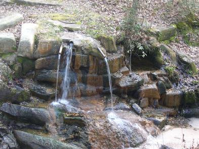
Boykin Creek and the nine-acre Boykin Springs Lake both pass through the facility, and the Sam Rayburn Reservoir is nearby.

The area is forested with pines and hardwoods. Wildlife is abundant, and the region is a hot spot for migratory birds.

Nearby Attractions

Sam Rayburn Reservoir

Reservation

More from CampingHiking.net:

PLOWMAN CREEK, Texas Campground Images, Info & Reservations

Listen Directions From Kopperl, Texas, travel 1 mile south on FM 56. Follow signs into campground. Phone 254-622-3332 Activities BIKING, BOATING, CAMPING, FISHING, HIKING, HORSEBACK RIDING Keywords PLOW,WHITNEY LAKE,LAKE WHITNEY,WHITNEY LAKE Related Link(s) Rec Area Info & Images Texas State Road Conditions Texas State Tourism Overview PLOWMAN CREEK CAMPGROUND IS

TWELVE MILE FLAT, Utah Campground Images, Info & Reservations

Listen Directions Travel east up Twelve Mile Canyon on Forest Development Road 22 for approximately 20 miles, or travel west up Ferron Canyon on Forest Development Road 22 for 31 miles. Phone 435-384-2372 Activities BIKING, CAMPING, HIKING, HUNTING, WILDLIFE VIEWING Keywords TWEM,MANTI-LASAL NF -FS Related Link(s) Rec Area Info &

MCGEE CREEK, California Campground Images, Info & Reservations

Listen Directions From U.S. Highway 395 in California, take the McGee Creek exit, located 8 miles south of Mammoth Lakes and 37 miles north of Bishop. Proceed 2 miles south up the paved McGee Creek Road. The campground is on the left. Phone 760-935-4213 Activities CAMPING, FISHING, HIKING, HORSEBACK RIDING,

LEAD HILL, Arkansas Campground Images, Info & Reservations

Listen Directions From Lead Hill, AR, travel 4 mi. on SR 7 N and follow signs into campground. Phone 870-422-7555 Activities BOATING, CAMPING, SWIMMING SITE Keywords LEAD,BULL SHOALS LAKE,BULL SHOALS LAKE Related Link(s) Rec Area Info & Images Arkansas State Tourism Arkansas State Road Conditions Overview Lead Hill Campground is

UPPER COFFEE POT, Idaho Campground Images, Info & Reservations

Listen Directions From West Yellowstone, Montana, take Highway 20 south for 23 miles. From Ashton, Idaho, take Highway 20 north for 32 miles. Turn west onto Forest Road 130 and travel 2 miles to the campground. Phone 208-558-7658 OR 208-270-0094 Activities BOATING, CAMPING, FISHING, HIKING, WILDLIFE VIEWING Keywords UPCP,Coffee Pot,CARIBOU-TARGHEE