GROUP CAMP, OK Campground Reservation, Info, Images, Map, Directions

GROUP CAMP, Oklahoma Campground Images, Info & Reservations

Listen

Directions

From Sawyer, OK, take Highway 147 north for nearly 4 miles, follow posted signs, and stay with the paved road to the campground.

Phone

580-326-0173

Activities

BOATING, CAMPING, FISHING, HIKING, WILDLIFE VIEWING

Keywords

Hugo Group

Related Link(s)

Rec Area Info & Images

Oklahoma State Tourism

Oklahoma State Road Conditions

Overview

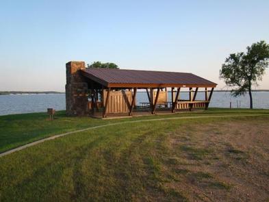
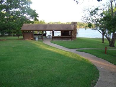
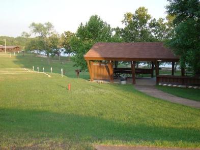
The Hugo Lake Group Camp is a large, grassy campground in a forested expanse of southeast Oklahoma. The camp is perched along the banks of Hugo Lake, providing guests with plenty of recreational opportunities.

Recreation

There are always fish to be caught at Hugo Lake. From early sand bass and slab crappie to late season fall bass, anglers will always find opportunities. Hugo Lake also provides excellent catfishing during the summer. The lake area offers plenty of hunting opportunities, with over 25,000 acres of land available. Bow hunting is permitted in and around most of the park areas. Kiamichi Park features an archery practice range and a 3,000-acre Quality Deer Management Area. Wildlife around the lake includes waterfowl, bobwhite quail, dove, whitetail deer, mink, fox and beaver.

Facilities

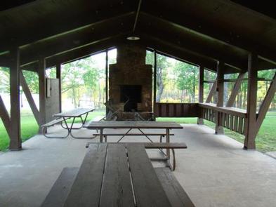
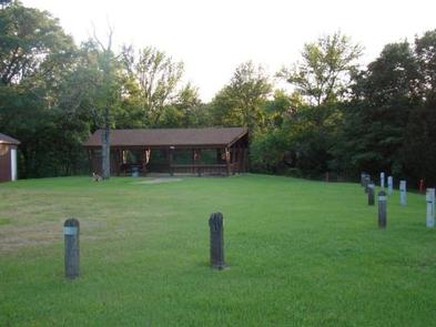
Hugo Lake Group Camp includes four group camping sites, which can accommodate up to 25 guests each. Each of these group camping sites has electrical hook-ups for four to five campers, as well as a large picnic shelter. A shared playground and easy lake access make Group Camp perfect for large parties, youth trips or family functions. Please be aware there is no running water at this facility at this time.

Natural Features

Hugo Lake dam is located on the Kiamichi River, 18 river miles upstream from its confluence with the Red River. The dam, completed in 1974, provides flood control, water supply and fish and wildlife management for nearby communities. It also provides a recreational oasis for outdoor enthusiasts of all types.

Nearby Attractions

A number of historical attractions are located near Hugo Lake, including Native American cultural centers, Civil War headquarters, historic churches and schools. Visit the lake website for more information.

Charges & Cancellations

A $10.00 service fee will apply if you change or cancel your reservation. Late cancellations are subject to additional fees. For full detaions see Recreation1Stop Reservation Policy.

Reservation

More from CampingHiking.net:

Dunewood Campground, Indiana Campground Images, Info & Reservations

Listen Directions Please use this link to get to the directions page on our website. https://www.nps.gov/indu/planyourvisit/directions.htm Phone 219-395-1882 Activities BIKING, BOATING, CAMPING, INTERPRETIVE PROGRAMS, FISHING, HIKING, PICNICKING, VISITOR CENTER, WILDLIFE VIEWING, SWIMMING SITE, INFORMATION SITE, ENVIRONMENTAL EDUCATION, PHOTOGRAPHY, SWIMMING, KAYAKING, CANOEING, BEACHCOMBING, BIRDING, WATER ACCESS, EVENING PROGRAMS, GUIDED INTERPRETIVE WALKS,

WILBUR D. MILLS, Arkansas Campground Images, Info & Reservations

Listen Directions From Dumas, Arkansas, travel north on US-165 for 9 miles to State Route 212. Turn right and continue 4 miles east, through Pendleton Bend Park, to the campground. Phone 870-548-2291 Activities BOATING, CAMPING, FISHING, HIKING, HUNTING, BIRDING Keywords WILB,WILBUR D. MILLS LOCK AND DAM,WILBUR MILLS PARK,MILLS PARK,WILBUR D

COTTONWOOD GROUP CAMPSITE, Wyoming Campground Images, Info & Reservations

Listen Directions From Afton, Wyoming, take Highway 89 south approximately 7 miles to Smoot. After a half-mile look for directional signs to Cottonwood Lake Campground. The Forest boundary is about one mile up the access road, and the campground is 6 miles beyond that. Continue past the first loop of

GRANITE FLAT (UTAH), Utah Campground Images, Info & Reservations

Listen Directions From Salt Lake City, Utah, take I-15 to the Alpine-Highland exit 284. Go east on Highway 92 for 8 miles to mouth of American Fork Canyon. Go 5 miles up the canyon to junction, take the North Fork/Forest Road 85 to Tibble Fork Reservoir. Stay left on paved

OAK (Navarro Mills Lake), Texas Campground Images, Info & Reservations

Listen Directions From Waco or Corsicana, Texas, take State Highway 31 to the intersection with FM 667. Turn north on FM 667 and travel about 1.5 miles to the park entrance on the left side of the road. Phone 254-578-1431 Activities BOATING, CAMPING, FISHING, SWIMMING SITE Keywords OAK1,NAVARRO MILLS LAKE,NAVARRO