

Directions
The county road from Springville to the cabins is narrow with many sharp turns, and vehicles over 22 feet are not advised. Take Highway 190 east from Porterville to Springville. After passing through Springville, take a left on Balch Park Road. Drive approximately 10.5 miles, then turn left onto Blue Ridge Dr./Co Route 276/Mtn Rd 276. Travel 6 miles to arrive at the Upper Grouse Valley Area on the right. Go through the gate and close and lock the gate behind you. Travel down the black-top paved road to the right, continue the same direction on the dirt road approximately a mile. The cabins will on your left through another gate, which should also be closed and locked upon entry. The Caretakers Cabin is located on the left immediately after the second gate. The Hillside Cabin is located on the right immediately after the second gate. The Lakeside Cabin is located at the end of the cabin driveway.
Phone
559-539-2607
Activities
BOATING, CAMPING, FISHING, HIKING, HORSEBACK RIDING, WILDLIFE VIEWING
Keywords
Upper Grouse Caretaker Cabin,Caretakers Cabin,Upper Grouse Lakeside Cabin,Lakeside Cabin,Upper Grouse Hillside Cabin,Hillside Cabin,Grouse Valley
Related Link(s)
California State Road Conditions
Overview
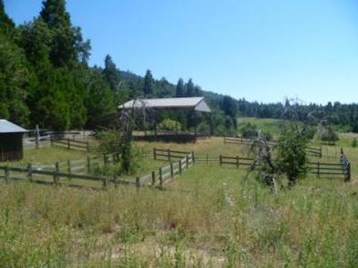
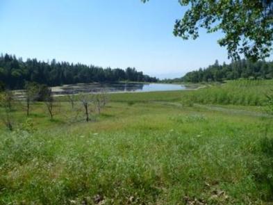
Grouse Valley is located in the Giant Sequoia National Monument within Sequoia National Forest. The facility is a complex of two cabins; the Lakeside Cabin and the Hillside Cabin. The Lakeside Cabin is the largest of the two and can accommodate up to 12 people. The Hillside Cabin accommodate up to 10 people. The property is nestled in an open scenic valley, which contains two lakes surrounded by pine and oak trees and a few small fruit and nut orchards. The serenity and open space provided at Upper Grouse presents visitors with a rare opportunity to enjoy the Sequoia National Forest apart from the traditional campground experience.
Recreation
Visitors are invited to fish, canoe, and hike around the lakes on the property. All California Department of Fish and Game and U.S. Forest Service regulations apply. There is a barn, hay shed, a pasture adjacent tot he Caretaker’s Cabin, and horse corrals for visitors who choose to bring their horses to ride.
Facilities
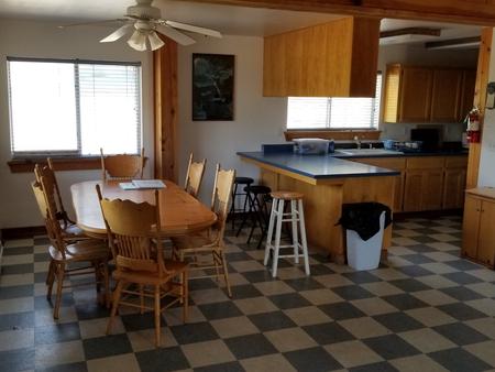
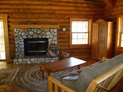
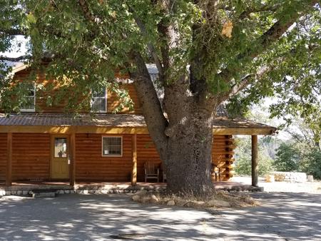
The 1,550 square foot Lakeside Cabin is two-story log cabin with an 8-foot covered deck on three sides. The 1,400 square foot Hillside Cabin is also a log cabin with an 8-foot deck on three sides. The cabins include a full kitchen, living and dining areas, full baths (the large house has two full baths) and large areas for bunks/beds. Additional amenities include hot showers, electricity, laundry facilities, and grills. If you plan on using the grill on the porch please bring your own charcoal briquettes. Cabin users should also provide linens, pillows, blankets, towels, toiletries, toilet paper, food and trash bags. Firewood can be purchased from local stores in Springville.
Natural Features
The Upper Grouse Valley is approximately a fifty minute drive north of Springville, California, at an elevation of around 4,800 feet. Vegetation on the property includes riparian, mixed conifer (ponderosa pine, incense cedar, and white fir), and fruit orchards. The property has a lower and an upper man-made lake. At 4,800 feet elevation, visitors need to be prepared for a variety of weather including warm afternoons, chilly nights and afternoon thunderstorms. It is also not unusual to experience a dusting of snow during the early spring and later fall months. The land surrounding the cabins is open to the public who must walk-in so other visitors may be in the vicinity during your stay.