BAD BEAR CAMPGROUND, ID Campground Reservation, Info, Images, Map, Directions

BAD BEAR CAMPGROUND, Idaho Campground Images, Info & Reservations

Listen

Directions

Hayfork Group Cg (ID) HIGHWAY 21 Idaho City ID 83706

Phone

208-392-6681

Activities

CAMPING, FISHING, VISITOR CENTER, WILDLIFE VIEWING

Keywords

None

Related Link(s)

Rec Area Info & Images

Idaho State Tourism

Idaho State Road Conditions

Overview

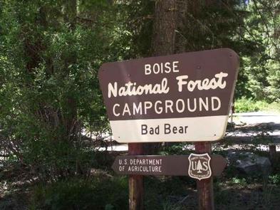
Bad Bear Campground is located 48 miles northeast of Boise, Idaho, in a scenic Ponderosa pine forest along Highway 21 at an elevation of 5,100 feet. Wildlife and summer wildflowers are abundant. Historic Idaho City is just 11 miles south. Mores Creek runs adjacent to the site, offering whitefish and rainbow trout fishing. Highway 21, also known as the Ponderosa Pine Scenic Byway, snakes along Mores Creek to Mores Creek Summit, Gold Fork, and Banner Ridge with breathtaking views of the surrounding mountains and forest.

Recreation

Numerous trail opportunities are in the area, offering hiking, biking, horseback riding, and ATVing. In winter, the area becomes a playground for backcountry skiers and snowmobilers.
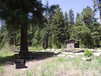
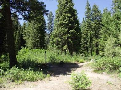
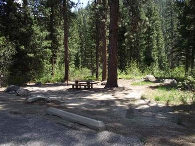
Facilities

This campground contains 6 sites that can accommodate up to 6 people each. Picnic tables, a charcoal BBQ grill, and fire ring with benches are profided. The site is in an open area with shade. Vault toilets and garbage service are provided. Parking spurs are paved. Due to its proximity to the highway, some noise from passing traffic is to be expected.

Nearby Attractions

Reservation

More from CampingHiking.net:

COLD SPRINGS, Colorado Campground Images, Info & Reservations

Listen Directions From Interstate 25 in Denver, go west on 6th Avenue to State Highway 6, through Clear Creek Canyon. Turn onto State Highway 119, heading toward Black Hawk and Central City. Follow the highway approx. 5 miles north of Black Hawk, to the campground. Phone 801-226-3564 Activities BIKING, CAMPING,

ALLRED FLATS GROUP PICNIC SITE, Wyoming Campground Images, Info & Reservations

Listen Directions From Afton, Wyoming, take Highway 89 south for approximately 21 miles over Salt Pass and look for a brown sign signaling the right-hand turn for Allred Flats Campground. The picnic area is on the left, just before the campground entrance kiosk. Phone 307-828-5100 Activities BIKING, CAMPING, FISHING, HIKING,

WATERVILLE CAMPGROUND, New Hampshire Campground Images, Info & Reservations

Listen Directions From Highway 93, take exit 28. Follow Highway 49 east for 10 miles, then turn left on Tripoli Road. The campground is 0.25 miles on the left. Phone 603-536-6100 Activities BIKING, BOATING, CAMPING, FISHING, HIKING, HORSEBACK RIDING, WINTER SPORTS, SWIMMING SITE Keywords WATE,WHITE MOUNTAIN NF -FS Related Link(s)

HOLMES BEND, Kentucky Campground Images, Info & Reservations

Listen Directions From Columbia, KY, take Cumberland Parkway to exit 49 and merge onto Highway 55 north. Continue for 1.5 miles, then turn right on Highway 551. After a mile turn left on Holmes Bend Road and follow directional signs to the campground. Phone 270-384-4623 Activities BIKING, BOATING, CAMPING, INTERPRETIVE

HURRICANE CREEK, Kentucky Campground Images, Info & Reservations

Listen Directions From Paducah, Kentucky: Take I-24 east to exit 45. Turn right on Highway 293 west and go 0.3 miles. Turn left on Highway 93 south, go 5.3 miles. Turn right on Highway 274 south, go 5.7 miles. Turn right on Hurricane camp road. Campground on left. From Nashville,

CHISOS BASIN (BIG BEND), Texas Campground Images, Info & Reservations

Listen Directions From Interstate 10, take highway 385 south to Fort Stockton and then on to Marathon. From Marathon, go 40 miles south on Highway 385 to the north entrance of Big Bend National Park. Drive straight 26 miles to Park Headquarters at Panther Junction. Turn right and drive for