HILLSBORO COVE, KS Campground Reservation, Info, Images, Map, Directions

HILLSBORO COVE, Kansas Campground Images, Info & Reservations

Listen

Directions

From Marion, Kansas, take Highway 56 for about five miles. Turn right on Nighthawk, then turn right again into the park.

Phone

620-382-2101

Activities

BOATING, CAMPING, FISHING, HUNTING, WILDLIFE VIEWING, SWIMMING SITE, SWIMMING, WATER ACCESS, ACCESSIBLE SWIMMING

Keywords

HILC,MARION RESERVOIR,MARION RESERVOIR

Related Link(s)

Rec Area Info & Images

Kansas State Road Conditions

Kansas State Tourism

Overview

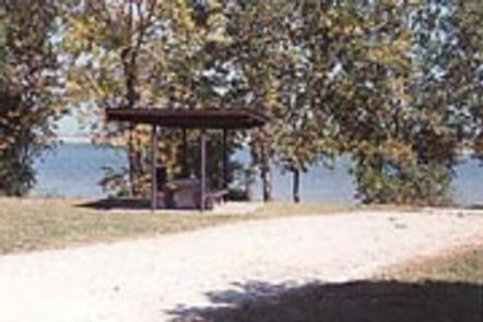
Hillsboro Cove is a quiet little campground conveniently located off Highway 56 between the towns of Marion and Hillsboro. It’s known for water front camping sites and readily acceessible boat ramp for fishermen.

Recreation

Popular activities include camping, boating, fishing and hunting. Anglers will find an abundance of Channel Catfish, Walleye, White Bass, Wipers, White Crappie and a boat ramp is provided at the campground for convenient access to the lake.

Facilities

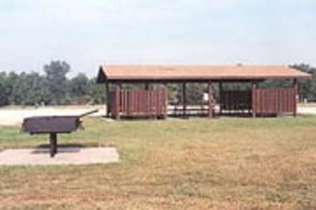
The campground offers 51 individual sites and one group camping area with a large shelter. The group camping area holds up to 80 people. The individual sites have tables, grills, sun shelters, electric hookups, and a boat ramp.

Natural Features

Completed in 1968, Marion Reservoir encompasses 6,200 acres of water surrounded by 6,000 acres of public lands. The surrounding expanse of forest provides visitors with endless recreational activities, set against the backdrop of the sparkling lake.

Nearby Attractions

The nearby communities of Hillsboro and Marion offer additional tourist attractions. Both cities have a nationally recognized Art and Crafts show, as well as a variety of restaurants and shops.

Reservation

More from CampingHiking.net:

CAL-IDA, California Campground Images, Info & Reservations

Listen Directions From Downieville, travel south on Highway 49 for about 13 miles. The campground is on the right side of the highway. Phone (530)478-6253 Activities BIKING, BOATING, CAMPING, FISHING, HIKING, HUNTING Keywords CALI,TAHOE NF – FS Related Link(s) Rec Area Info & Images California State Tourism California State Road

CLEAR SPRING, Texas Campground Images, Info & Reservations

Listen Directions From Texarkana, take Highway 59 south. Turn right (west) on Farm-to-Market (FM) Road 2148 and follow to Wright Patman Lake entrance. Follow the park road west to the entrance. Phone 903-838-8636 Activities BOATING, CAMPING, FISHING, HUNTING, SWIMMING SITE Keywords CLES,WRIGHT PATMAN DAM AND LAKE,CLEAR SPRINGS,WRIGHT PATMAN DAM Related

BERRY MOUNTAIN PARK SHELTER, North Carolina Campground Images, Info & Reservations

Listen Directions From Charlotte, North Carolina, take I-77 North (approximately 60 miles) before merging onto Highway 421 North towards Wilkesboro/Boone. Continue to Exit 286B (approximately 20 miles), turn left onto Highway 268 and continue for approximately 4 miles. Berry Mountain Park will be on the right. From Winston-Salem, North Carolina,

MAHOGANY GROVE, Nevada Campground Images, Info & Reservations

Listen Directions From Las Vegas, Nevada, take Highway 95 north to the junction with Highway 157/Kyle Canyon. Turn left and travel approximately 18 miles to junction with Highway 158/Deer Creek. Turn right and travel approximately 6 miles to the campground. Phone 702-872-5486 Activities CAMPING Keywords MAHO,MOUNT CHARLESTON,LAS VEGAS,SPRING MTNS NAT