RILEY CREEK, ID Campground Reservation, Info, Images, Map, Directions

RILEY CREEK, Idaho Campground Images, Info & Reservations

Listen

Directions

From Highway 2 in Laclede, Idaho, turn south onto Riley Creek Road, then continue about 1 mile to the campground entrance.

Phone

208-437-3133

Activities

BIKING, BOATING, CAMPING, INTERPRETIVE PROGRAMS, FISHING, HIKING, PICNICKING, WATER SPORTS, WILDLIFE VIEWING, DAY USE AREA, SWIMMING SITE

Keywords

RILC,ALBENI FALLS DAM

Related Link(s)

Rec Area Info & Images

Idaho State Road Conditions

Idaho State Tourism

Overview

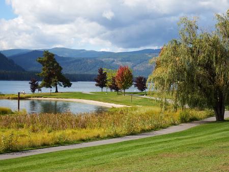
Riley Creek Recreation Area, situated on the banks of the Pend Oreille River, is the largest recreation area for the Albeni Falls Project, but still offers visitors peace and quiet and plenty of space to enjoy the scenic surroundings.

Recreation

Water sports are the most common activity at the lake, and boat ramps are provided at the campground. Visitors enjoy kayaking, canoeing, swimming, fishing, water skiing and jet skiing. Campers are likely to spot wildlife in the area, with bald eagles, osprey, bears and most commonly, deer. A biking and hiking trail is available, giving campers a chance to enjoy the wildlife and greenery. Fishing piers, horseshoe pits, a beach volleyball court, basketball court and more make this campground an ideal place for family trips or groups of friends. A hiking and biking trail is accessible from the campground.

Facilities

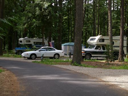
Riley Creek is the largest campground at Albeni Falls, offering 67 campsites, all with electric and water hookups. Two large reservable picnic shelters are also available.

As long as all equipment fits on the site pad, Riley Creek allows for an unlimited amount of tents per site.

Natural Features

Albeni Falls Dam was built in 1955 for flood control and power production on the Pend Oreille River. Today, the popular lake has the added benefit of providing visitors with countless year-round recreational activities.

Lake Pend Oreille is surrounded by scenic mountains and is one of the largest and deepest natural lakes in the western United States, plunging to depths of more than 1,200 ft. in some areas.

Behind the dam, the Pend Oreille River stretches 65 miles through a glacial-carved valley that separates three mountain ranges.

Nearby Attractions

The Albeni Falls Visitor Center features exhibits on the history of the dam and the natural features of the area. Tours of the dam are given daily during the summer. The nearby town of Laclede, Idaho offers gas and grocery services.

Reservation

More from CampingHiking.net:

ASPEN GLADE, Colorado Campground Images, Info & Reservations

Listen Directions From Antonito, Colorado, go west on Highway 17 for approximately 15 miles to the Aspen Glade Campground. Phone 435-245-6521 Activities CAMPING, FISHING Keywords ASGL,RIO GRANDE NF- FS Related Link(s) Rec Area Info & Images Colorado State Road Conditions Colorado State Tourism Overview Aspen Glade Campground sits on the

LITTLE COTTONWOOD CAMPGROUND, Utah Campground Images, Info & Reservations

Listen Directions Travel east of Beaver approximately 6 miles on SR 153. Phone 435-438-2436 Activities CAMPING, FISHING, HIKING, VISITOR CENTER, WILDLIFE VIEWING Keywords LITTLE COTTONWOOD CAMPGROUND,LITTLE COTTONWOOD,COTTONWOOD,FISHLAKE NATIONAL FOREST Related Link(s) Rec Area Info & Images Utah State Road Conditions Utah State Tourism Overview The Little Cottonwood Campground is conveniently

BOISE CREEK, California Campground Images, Info & Reservations

Listen Directions From Willow Creek, California, take State Route 299 for 2 miles west. Enter the campground directly from the highway. Phone 530-629-2118 Activities BIKING, BOATING, HISTORIC & CULTURAL SITE, CAMPING, FISHING, HIKING, HUNTING, VISITOR CENTER, WATER SPORTS, WILDLIFE VIEWING, SWIMMING SITE Keywords BOCR,Boise Creek Campground Related Link(s) Rec Area

FOX CREEK HORSE CAMP, Virginia Campground Images, Info & Reservations

Listen Directions From exit 45 on I-81, take State Route 16 South for approximately 17 miles to State Route 603 at Troutdale, Va. Turn right on State Route 603. Campground is approximately 4 miles down 603 on the right. Phone 800-628-7202 Activities CAMPING, FISHING, HORSEBACK RIDING, HUNTING, WILDLIFE VIEWING Keywords

COY FLAT, California Campground Images, Info & Reservations

Listen Directions From Highway 99 go east on 190 to Springville, California. On 190 travel 15 miles to Nelson Drive. From Nelson Drive exit on Coy Flat and drive 1.5 miles to campground. Phone 559-539-5230 Activities CAMPING, FISHING, HIKING Keywords COYF,GIANT SEQUOIA NATIONAL MONUMEN,SEQUOIA NF – FS Related Link(s) Rec