

Directions
From Sequim east, for approximately 3 miles. Just past John Wayne Marina Road, turn right onto the Palo Alto Road and travel approximately 8 miles. The access drive to Louella Cabin is by an information kiosk on the right. Turn into the driveway, go past the first building, and Louella Cabin is on the right. Access to the cabin by vehicle may require chains in the winter during periods of heavy snow; the last 1/8 mile of road is not plowed.
Phone
360-765-2200
Activities
CAMPING, FISHING, HIKING, HUNTING, WILDLIFE VIEWING, MOUNTAIN BIKING, BIRDING
Keywords
LOUE,OLYMPIC NF – FS
Related Link(s)
Washington State Road Conditions
Overview
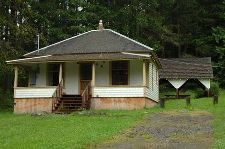
Located in the northeast portion of Olympic National Forest, Louella Cabin offers guests a unique lodging experience. It was built in 1912 by Forest Service employee, E. M. Cheney, who dedicated the structure to his wife, Louella. A fireguard was stationed at the cabin during the summer and fall. During the Great Depression, a Civilian Conservation Corps (CCC) camp was built in the lower part of the meadow below the cabin and consisted of barracks, a bathhouse and mess hall. The CCC has worked on many projects in the area, including fire lookouts, trails, bridges, roads and planting trees after forest fires. After the CCC camp closed in 1939, the guard station was used by various agencies until 1976. Today, the site offers guests year-round recreation and relaxation in Olympic National Forest. Access to the cabin is by vehicle; however, snow chains may be required in winter. The cabin offers several amenities, but guests will need to bring a few of their own supplies for a truly enjoyable stay.
Recreation
The cabin is conveniently located near the Buckhorn Wilderness, which offers excellent opportunities for backpacking, horseback riding, hunting, mountain climbing and hiking, with over 58 miles of trails. Anglers will enjoy fishing the Dungeness River, and are drawn to it for steelhead and cutthroat trout, as well as chinook, coho and pink salmon. The river has its headwaters high on Mount Mystery in Olympic National Park, and descends into Dungeness Bay on the Strait of Juan de Fuca.
Facilities
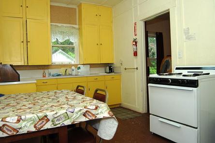
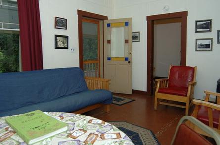
The four-room cabin can accommodate six people. The living room has a futon. One bedroom has a queen bed and the other has twin bunk beds. The kitchen has a table and chairs, cook stove, refrigerator, dishes, pots, silverware and cooking utensils. The cabin also has electricity and a propane heater. Propane is furnished. An outdoor portable toilet is available that is serviced weekly. There is also a fire ring near the cabin for outdoor barbecuing and campfires, as well as a covered picnic table. No drinking water is available at this facility. Guests must bring enough water for cooking, drinking and other household uses throughout their stay. Guests need to provide their own sleeping bags, pillows, flashlights, towels, dish soap, matches, cleaning supplies first aid kit, toilet paper and garbage bags. All trash and food must be packed out, and guests are expected to clean the cabin before leaving. Please leave nothing behind, if you would like to make a donation of goods to the cabin please contact the Ranger Station for a list of needs.
Natural Features
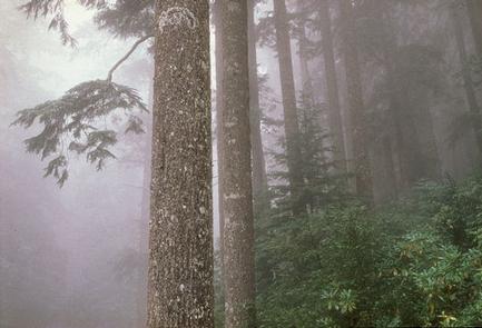
Louella Cabin sits on a gentle slope overlooking a valley and flanked by a canopy of towering Douglas fir.
Buckhorn Wilderness is accessible from the cabin. Located in the northeast corner of Olympic National Forest, the wilderness area is divided into northern and southern portions by the Dungeness River. The northern portion descends from higher mountainous terrain to lowlands, heavily forested in fir, hemlock, and cedar with an understory of moss, ferns, and berry bushes. South of the river, the terrain soars skyward to alpine meadows and rocky ridges.
Magnificent old-growth western hemlock, western red cedar and Douglas fir dominate the forest, providing habitat for elk, black-tailed deer, black bears and mountain lions.
Nearby Attractions
Take some time to visit the area around the historic Tubal Cain mine in the nearby Buckhorn Wilderness or hike to views of the Olympic mountains and Buckhorn Wilderness from the Ned Hill Lookout site. Visitors also enjoy access to Olympic National Park from this area. Take some time to visit Olympic National Park, known for its diverse and spectacular ecosystems.