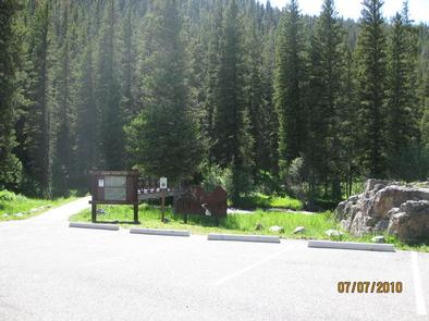
LANGOHR CAMPGROUND, MONTANA Campground Reservation, Info, Images, Map, Directions

LANGOHR CAMPGROUND, Montana Campground Images, Info & Reservations

Listen

Directions

From Main Street in Bozeman, travel south along 19th Avenue for 7 miles, to the paved Hyalite Canyon Road. Turn left and continue south for about 5 miles, to the campground.

Phone

(406)646-1012

Activities

BIKING, CAMPING, FISHING, HIKING, WILDLIFE VIEWING, PHOTOGRAPHY, MOUNTAIN BIKING, STAR GAZING, BIRDING, WATER ACCESS, BACKPACKING

Keywords

LANG,LANGOHR SPRING,GALLATIN NF – FS

Related Link(s)

Rec Area Info & Images

Montana State Road Conditions

Montana State Tourism

Forest Service Concessionaire

Overview

Langohr Campground is located in scenic Hyalite Canyon on the Bozeman Ranger District of the Gallatin National Forest. It is located just 12 miles south of Bozeman, Mont.

The surrounding area offers many outdoor recreational opportunities, including fishing, hiking and climbing.

Recreation

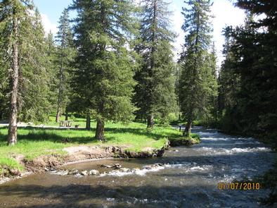
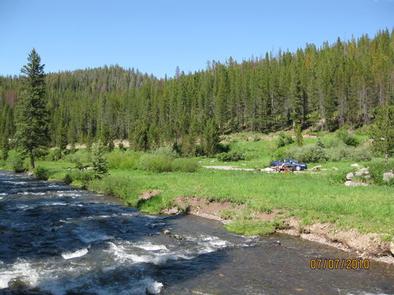
Hyalite Creek provides great fishing for Yellowstone cutthroat, Arctic grayling and brook trout. Many hiking trails can be found in Hyalite Canyon.

Facilities

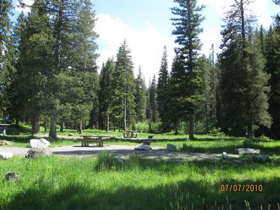
The campground offers several single-family campsites. A GROUP PICNIC AREA (SITE 20) for DAY USE ONLY is also available and can accommodate up to 50 people. Tables and campfire rings are provided, as are vault toilets, drinking water and trash collection.

Natural Features

The campground sits next to Hyalite Creek, at an elevation of 6,200 feet. Most campsites are situated in open meadows along the creek. Some are located among scattered pine and fir trees.

Nearby Attractions

Hyalite Reservoir is just 3.5 miles from the campground. The scenic 206-acre lake offers many recreational activities, including boating, canoeing, fishing, hiking, climbing and picnicking.

The popular Hyalite Peak Trail begins near the reservoir. The 7.5-mile one-way trail gains 3,450 feet in elevation as is climbs past numerous waterfalls to beautiful Hyalite Lake and Peak.

Reservation

More from CampingHiking.net:

VAN HOOK GLADE, North Carolina Campground Images, Info & Reservations

Listen Directions From Highlands, North Carolina, follow Highway 64 west approximately 4.5 miles. The campground entrance is on the right. Phone 828-526-5918 Activities CAMPING, FISHING, HIKING, SWIMMING SITE Keywords VANH,HIGHLANDS,NFs IN NORTH CAROLINA – FS Related Link(s) Rec Area Info & Images Forest Service Concessionaire North Carolina State Tourism North

MOSER ISLAND CABIN, Alaska Campground Images, Info & Reservations

Listen Directions Accessible year round, weather permitting. Located 48 air miles north of Sitka, within Hoonah Sound on the north end of Moser Island, north of Peril Strait. Access from Sitka is 30 minutes by floatplane, or 2 hours by boat. For geographic features surrounding the cabin, refer to USGS

POTTERS POND, Utah Campground Images, Info & Reservations

Listen Directions From Price, Utah, travel south on Highway 10 for 20 miles, to Huntington. Turn right onto Highway 31 and travel northwest for 30 miles. Turn south onto Miller Flat Road and travel 11 miles. Turn right onto Potter Canyon Road and continue for less than a mile to

CRANESNEST CAMPGROUND (VA), Virginia Campground Images, Info & Reservations

Listen Directions From Clintwood, VA main street turn left onto Rt. 83. Travel 2.6 miles and turn left onto Cranesnest Campground Rd. Travel 2.8 miles to the campground. Phone 276-835-9544 Activities BIKING, BOATING, CAMPING, FISHING, HIKING, HORSEBACK RIDING, PICNICKING, WILDLIFE VIEWING Keywords Related Link(s) Rec Area Info & Images Virginia