SCOUT MOUNTAIN CAMPGROUND, ID Campground Reservation, Info, Images, Map, Directions

SCOUT MOUNTAIN CAMPGROUND, Idaho Campground Images, Info & Reservations

Listen

Directions

Take I-15 to exit 63 south of Pocatello. Follow the brown Mink Creek Recreation Area signs to Bannock Highway for 2 miles. Turn left up the canyon. Go 4.5 miles to the East Fork Mink Creek road and turn left. Go 5.3 miles up East Fork Mink Creek road to the campground.

Phone

208-236-7500

Activities

BIKING, CAMPING, HIKING, WILDLIFE VIEWING

Keywords

SCMT,Justice Park,Scout,Sterling Justice Park,CARIBOU-TARGHEE NF – FS

Related Link(s)

Rec Area Info & Images

Idaho State Tourism

Idaho State Road Conditions

Overview

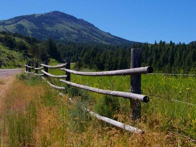
Scout Mountain Campground is located on beautiful Scout Mountain at an elevation of 6,900 feet, just 13 miles south of Pocatello, Idaho. Scout Mountain is part of the Mink Creek area, a popular place for birding and wildlife viewing. Visitors enjoy exploring a variety of local multi-use trails.

Recreation

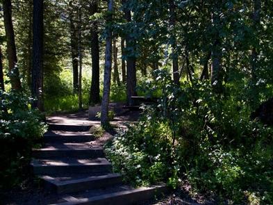
Hiking, mountain biking, horseback riding and dirt biking are very popular activities in the area. The paved 1-mile Scout Mountain Nature Trail loops the campground, leading to several overlooks. The East Fork Mink Creek Trail begins within the site and the Crestline Trail is nearby.

Facilities

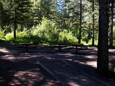
The campground contains one large group site for up to 100 people, with picnic and serving tables, grills and a campfire ring with benches.

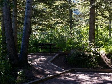
Single and double sites are available as well, with picnic tables, campfire rings, lantern posts and tent pads.

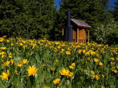
Vault toilets and drinking water are provided.

Natural Features

The campground sits high atop the Bannock Mountain Range in a scenic forest of Douglas fir, lodgepole pine and aspen, which offers partial shade. Summer wildflowers are abundant.

A wide variety of birds can be found in the area, including the Western Scrub-Jay, Juniper Titmouse, Bushtit, Blue-gray Gnatcatcher, Mountain Bluebird, Green-tailed and Spotted Towhees and Calliope Hummingbirds.

Nearby Attractions

Cherry Springs Nature Area is less than 6 miles from the campground, with its pretty namesake spring, a stream for fishing, paved self-guided nature trails and picnic facilities. Mink Creek Nordic Center is about 5 miles away, with hiking and horseback riding trails in summer months and groomed cross-country ski trails in the winter.

Charges & Cancellations

A $10.00 service fee will apply if you change or cancel your reservation. Late cancellations are subject to additional fees. For full details see NRRS Reservation Policy.

Reservation

More from CampingHiking.net:

MCCART LOOKOUT, Montana Campground Images, Info & Reservations

Listen Directions From Missoula, Montana, travel south on Highway 93 for approximately 90 miles to Sula. Go east on Highway 472 for about 15 miles and then south on Forest Road 5765/McCart Road for about 6 miles to the Johnson Peak Trailhead. Hike about 1.5 miles to the lookout tower.

WASHINGTON IRVING SOUTH, Oklahoma Campground Images, Info & Reservations

Listen Directions From Tulsa, Oklahoma, take Highway 412 west for 15 miles to Bears Glen exit. Turn left at stop sign onto the Frontage Road and drive 1 block. Turn right at first paved road and follow 2 miles to the campground entrance. Phone 918-865-2621 Activities BOATING, CAMPING, FISHING, HIKING,

JOHN C. BRISCOE GROUP USE, Missouri Campground Images, Info & Reservations

Listen Directions From Hannibal, MO, travel west on highway 36 for 17 miles, then continue south on Route J and head south 10 miles. From Perry, travel north on Rt. J for 9 miles. Phone 573-735-4097 Activities CAMPING Keywords MWBG,BOUDREAUX GROUP CAMP AREA,MARK TWAIN LAKE,MW Boudreaux Group Camp,Briscoe Group Camp,Boudreaux

HILLTOP, Nevada Campground Images, Info & Reservations

Listen Directions From Las Vegas, travel north on Highway 95 to the junction with Highway 157/Kyle Canyon. Turn left and travel approximately 17 miles to the junction with Highway 158/Deer Creek. Turn right and travel about 4 miles to the campground on the right side of the road. Phone 702-872-5486

GIRD POINT, Montana Campground Images, Info & Reservations

Listen Directions From Hamilton, Montana, travel east on Highway 38 for about 7 miles. Turn north onto Gird Road/Forest Road 714 and continue for about 13 miles to the Gird Point Lookout Trailhead. The tower is approximately 1/2 mile hike from the parking area. Phone 406-821-3913 Activities BIKING, CAMPING, HIKING,

SANDY FLAT, California Campground Images, Info & Reservations

Listen Directions From Highway 99, take Highway 178 east for 4 miles. Turn right on Borel Road, then right onto the Old Canyon Road. Continue about 2 miles, then turn right into Sandy Flats Campground. Phone 760-376-1815 Activities CAMPING, FISHING Keywords SANF,Sandy Flat Related Link(s) Rec Area Info & Images