ST. CHARLES CAMPGROUND, UT Campground Reservation, Info, Images, Map, Directions

ST. CHARLES CAMPGROUND, Utah Campground Images, Info & Reservations

Listen

Directions

From U.S. Highway 89 in St. Charles, turn west onto Forest Road #412 and travel approximately 3 miles to the forest boundary. The campground entrance is just around the bend.

Phone

541-351-1182

Activities

BIKING, BOATING, CAMPING, FISHING, HIKING, HUNTING, WATER SPORTS, SWIMMING SITE

Keywords

SCRL,ST CHARLES CAMPGROUND,CARIBOU-TARGHEE NF – FS

Related Link(s)

Rec Area Info & Images

Forest Service Concessionaire

Idaho State Tourism

Idaho State Road Conditions

Overview

St. Charles Campground is situated on its namesake creek in the scenic St. Charles Canyon, approximately 8 miles from Bear Lake State Park and North Beach.

Recreation

Nearby, the North Fork Trail and its associated trails access the Highline Trail #316. The Highline Trail is part of the National Trail System and is the area’s premier trail. It stretches 55 miles along the backbone of the Wasatch Mountains and is open to hikers, mountain bikers, horseback riders and motorcyclists, attracting trail users from around the world.

The Idaho Department of Fish and Game manages the river fisheries, providing good to excellent fishing most of the year, including in St. Charles Creek. In-season big game hunting is also a popular activity.

Facilities

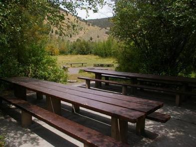
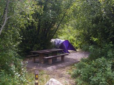
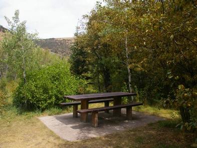
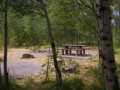
The campground offers one group site that can accommodate up to 20 people. Six single sites are also available. Flush toilets and drinking water are provided. A paved road leads to the campground.

Natural Features

Stands of aspens provide partial shade, while lodgepole pines, willow, dogwoods, Engelmann spruce and wild roses dot the landscape. The varied vegetation provides plenty of privacy from site to site.

Nearby Attractions

Minnetonka Cave, one of only two developed caves in the Forest Service, is a few miles from the campground. Guided cave tours are scheduled every 30 minutes daily from early June until Labor Day.

The Bear Lake National Wildlife Refuge is just north of Bear Lake, offering excellent bird watching.

Bear Lake’s Raspberry Days Festival occurs the first weekend in August every year, with a parade, fireworks, craft booths and a rodeo.

Reservation

More from CampingHiking.net:

BEAVER CREEK (IDAHO), Idaho Campground Images, Info & Reservations

Listen Directions From Priest River, Idaho, take Highway 57 north to Nordman, then turn right on Reeder Bay Road and continue for 12 miles into the campground. Phone 435-245-6521 Activities BIKING, BOATING, CLIMBING, CAMPING, FISHING, HIKING, WILDLIFE VIEWING, SWIMMING SITE, BIRDING Keywords Beaver Creek,beavercreek,BEC4,BEAVER CREEK IDAHO,IDAHO PANHANDLE NF – FS

CUTTHROAT, Arizona Campground Images, Info & Reservations

Listen Directions From Pinetop, Arizona, take Highway 260 east 60 miles to Highway 261 south. Follow Highway 261 south 20 miles to and turn right (south) onto Forest Road 115. Proceed 1 mile to Cutthroat Campground. Phone 928-735-7313 Activities BOATING, CAMPING, FISHING Keywords CUTT,BIG LAKE,APACHE-SITGREAVES NF-FS Related Link(s) Rec Area

Alpine Meadows Campground, California Campground Images, Info & Reservations

Listen Directions From State Highway 267, turn onto Martis Dam Road. Continue on Martis Dam Road for approximately 1.2 miles. Tur miles. Turn right a 0.2 miles to the campground entrance. You have now arrived at the entrance to Alpine Meadows Campground.  Phone (530) 587-8113 Activities BIKING, CAMPING, FISHING, PICNICKING,

SPARROWFOOT, Missouri Campground Images, Info & Reservations

Listen Directions From Highway 13, travel about a mile east on SE 450 Road and follow signs into the park. Phone 660-885-7546 Activities BOATING, CAMPING, FISHING Keywords SPAF,TRUMAN LAKE,HARRY S TRUMAN Related Link(s) Rec Area Info & Images Missouri State Road Conditions Missouri State Tourism Overview SPARROWFOOT CAMPGROUND WILL REMAIN

CEDAR CANYON, Utah Campground Images, Info & Reservations

Listen Directions From Cedar City, Utah, take Highway 14 east for 11 miles. Campground is located just below the S turn on your left. Phone 801-226-3564 Activities CAMPING, HIKING, MOUNTAIN BIKING, SCENIC DRIVE Keywords CED2,CEDAR CITY,CEDAR BREAKS NAT. MONUMENT,DIXIE NF – FS Related Link(s) Rec Area Info & Images Utah

GRANITE FLAT (CALIFORNIA), California Campground Images, Info & Reservations

Listen Directions From Truckee, take Highway 89 south approx. 1 mile to the campground. Phone (530)587-3558. FOR RESERVATIONS, PLEASE CALL: 1 (877) 444-6777. Activities BIKING, CAMPING, FISHING, HIKING, WATER SPORTS, SWIMMING, MOUNTAIN BIKING Keywords GRFL,GRANITE FLAT CALIFORNIA,TAHOE NF – FS Related Link(s) Rec Area Info & Images California State Tourism