EAST KACHESS GROUP SITE, WA Campground Reservation, Info, Images, Map, Directions

EAST KACHESS GROUP SITE, Washington Campground Images, Info & Reservations

Listen

Directions

From points west, take I-90 to exit 70. Turn left over freeway, then left again onto West Sparks Road. Follow West Sparks Road 0.5 mile and turn right onto Kachess Dam Roas/ Forest Road #4818. Travel approximately 5 miles to the campground on left. From points east, take I-90 to exit 70. Turn right, then left onto West Sparks Road. Follow West Sparks Road 0.5 mile and turn right onto Kachess Dam Roas/ Forest Road #4818. Travel approximately 5 miles to the campground on left.

Phone

509-852-1100

Activities

CAMPING, FISHING, HIKING, PHOTOGRAPHY, SWIMMING, KAYAKING, CANOEING, BIRDING

Keywords

EKAC,BOEING CAMP,OLD BOEING CAMP,BOEING ORGANIZATION SITE,OLD BOEING ORGANIZATION SITE,OKANOGAN – WENATCHEE NF -FS

Related Link(s)

Rec Area Info & Images

Washington State Tourism

Washington State Road Conditions

Overview

East Kachess Group Site is closed for the 2019 camping season.

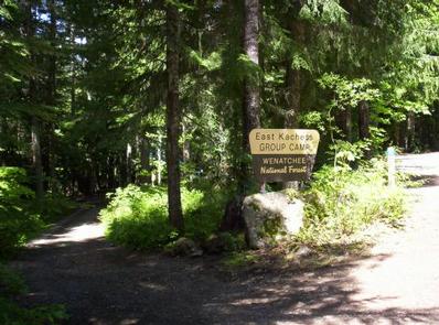
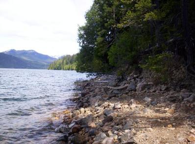
East Kachess Group Campground is tucked away on the eastern shore of Kachess Lake in Okanogan-Wenatchee National Forest.

Hemmed in by dense old-growth conifer forest and surrounded by high mountains, East Kachess Group Campground is secluded, making it an ideal setting for groups and families seeking recreation and relaxation.

Recreation

This is a prime base camp for hiking, fishing, swimming, and mountain biking in summer and early fall and several trails are a short drive from the area.

Anglers will enjoy the scenic backdrop of the area while fishing for rainbow trout, cutthroat trout and kokanee salmon from boat or shoreline.

Facilities

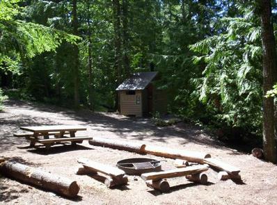
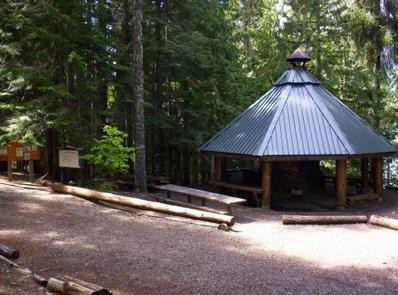
East Kachess Group Campground has one large group site, able to accommodate up to 100 people and 25 vehicles. The campground is equipped with picnic tables, campfire rings with grills and vault toilets.

Natural Features

Kachess Lake, adjacent to the campground, is a reservoir that stores and provides water for irrigation for south-central Washington. The area is quite scenic, supporting wildlife such as deer, porcupine, native fish and migratory birds. These species, along with many others, depend on surrounding undeveloped wilderness, clean streams, and diverse forests to live. Endangered and threatened species including the northern spotted owl and gray wolves also find havens in nearby ecosystems.

Nearby Attractions

Hikers may want to traverse at least a portion of the spectacular Pacific Crest Trail (PCT), one of the world’s premier National Scenic Trails. This trail showcases some of North America’s most fantastic scenery as it winds its way its way from Mexico to Canada through California, Oregon and Washington.

Reservation

More from CampingHiking.net:

FALL LAKE, Minnesota Campground Images, Info & Reservations

Listen Directions Fall Lake is located in Northeast MN, 100 miles North of Duluth MN. From Duluth, MN, take Highway 53 north for 50 miles to Virginia, MN. Take Highway 169 northeast for 50 miles to Ely, Minnesota, travel an addition 6.5 miles to County Road 182 (Fall Lake Road).

OHANAPECOSH GROUP CAMPGROUND, Washington Campground Images, Info & Reservations

Listen Directions Located on State Route 123, four miles north of State Route 12. Phone 360-569-2211 x6627 Activities CAMPING, HIKING, PICNICKING, DAY USE AREA Keywords CG81,Ohana,Mount Rainier National Park Related Link(s) Rec Area Info & Images Washington State Road Conditions Washington State Tourism Overview This facility is the group site

BONANZA CCC GROUP CAMPGROUND, Idaho Campground Images, Info & Reservations

Listen Directions From Highway 75, turn onto Yankee Fork Road (Forest Road 013) at Sunbeam Dam overlook. Travel approximately seven miles north on Yankee Fork Road and turn left at the Bonanza Guard Station onto Forest Road 074. Continue for approximately half a mile to the campground. Phone 208-879-4100 Activities

CRESCENT, Georgia Campground Images, Info & Reservations

Listen Directions From Hartwell, Georgia, take Hwy 29 north for approximately 8 miles (you will cross into South Carolina). Turn left onto Ginn Road. Take the first left onto Campers Way and continue straight to the campground. From Anderson SC, take Hwy 29 South from Anderson, heading south towards Hartwell,

PEACE VALLEY CAMPGROUND, Idaho Campground Images, Info & Reservations

Listen Directions From Garden Valley, Idaho, take Forest Road 698 north approximately 16 miles north. Turn right at the junction of FR 698 and FR 671. Take FR 671 for about 10 miles to the campground, which is on the left-hand side of the road. Phone 541-351-1182 Activities BIKING, CAMPING,

BOWMAN BRIDGE, Michigan Campground Images, Info & Reservations

Listen Directions From Baldwin, turn west on 7th Street, then left onto Cherry Street. Take the first right, W 52nd Street, and drive 5 miles. Look for signs into the campground. Phone 231-745-8760 Activities CAMPING, FISHING, WATER ACTIVITIES Keywords BOWM,HURON-MANISTEE NF -FS,BOWMAN’S BRIDGE Related Link(s) Rec Area Info & Images