
Directions
From Phoenix, Arizona: When traveling Northbound on I-17 take the Bumble Bee Exit 248 and continue North on the dirt road, taking Forest Road (FR) 259 to Crown King. From Crown King, take (FR) 259A south for 0.5 mile to the junction of 52. Take FR 52 southeast for about 5 miles to the Horse Thief Basin Recreation Area. The cabin sits adjacent to the Horse Thief Lake Rd.
Alternate route from Flagstaff, Arizona: Traveling Southbound on I-17 take Exit 263, turn right and proceed towards a roundabout and merge onto Hwy 69 North towards Prescott for 2.4 miles until turning left on to Spring Ln. in Spring Valley. Continue down Spring Ln. for 0.7 Miles until you get to Duffers Dr. turn right onto Duffers Dr. The road will become unpaved, continue to travel for 1.4 miles until you get to the intersection of Duffers Dr. and S. Antelope Creek Rd. and turn left and drive for 23 miles until arriving to Crown King, Arizona. From Crown King, take (Forest Rd) 259A south for 0.5 mile to a junction with 52. Take FR 52 southeast for about 5 miles to the Horse Thief Basin Recreation Area.The cabin sits adjacent to the Horse Thief Lake Rd.
From Prescott, Arizona: From Downtown Prescott travel South on State Route 69 for 31 miles until you arive to Spring Valley, Arizona and turn right onto Spring Ln. Continue down Spring Ln. for 0.7 Miles until you get to Duffers Dr. turn right onto Duffers Dr. The road will become unpaved at this point, continue to travel for 1.4 miles until you get to the intersection of Duffers Dr. and S. Antelope Creek Rd. and turn left and drive for 23 miles until arriving to Crown King, Arizona From Crown King, take 259A south for 0.5 mile to a junction with 52. Take FR 52 southeast for about 5 miles to the Horse Thief Basin Recreation Area. The cabin sits adjacent to the Horse Thief Lake Rd.
Phone
1 (877) 444-6777
Activities
BIKING, BOATING, CAMPING, FISHING, HIKING, HUNTING, WILDLIFE VIEWING
Keywords
HOTH,PRESCOTT NF – FS
Related Link(s)
Overview
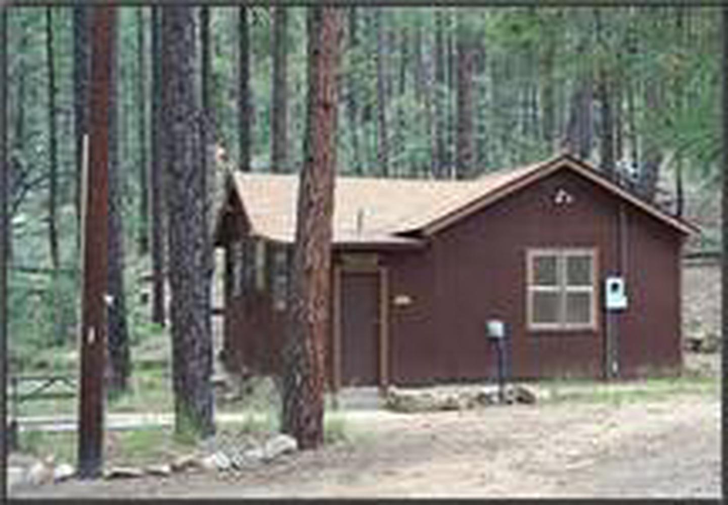
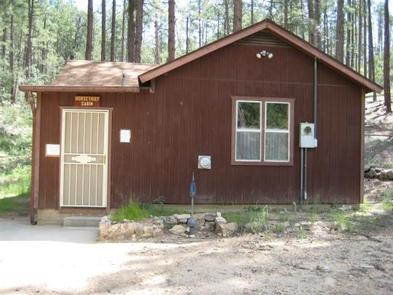
Horsethief Cabin is situated in a clearing of Ponderosa pines at an elevation of over 6,000 feet in the Bradshaw Mountains of the Prescott National Forest.
The original cabin was built in 1939 as quarters and a staging area for Forest Service crews charged with protecting the southern end of the Bradshaw Mountains against wildfires. The cabin was remodeled and modernized over the years, but eventually fell into disuse by the 1980s.
The historic structure now enjoys a second life as a rental cabin, providing a unique recreation opportunity for visitors to the Prescott National Forest. To make reservations select the date range on this site or call 1 (877) 444-6777. For general cabin question contact the Bradshaw Ranger District at 1 (928) 443-8000.
Recreation
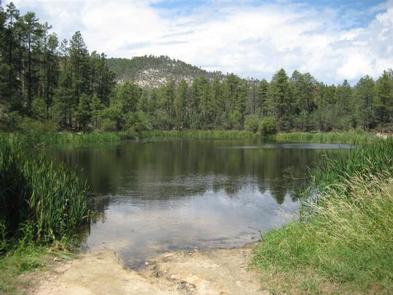
Anglers will appreciate the short hike from the cabin to Horsethief Basin Lake, stocked with largemouth bass, channel catfish and sunfish. Non-motorized boating is also available at the lake. Hikers have plenty of opportunities to explore the area on trails leading to Horsethief Canyon, Twin Peaks, Castle Creek and Jim Creek. Off-highway vehicles have several roads and trails available for travel, and a Forest Service fire lookout tower and a campground are in close proximity.
Facilities
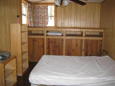
The cabin can accommodate up to six people and is furnished with four beds, including, two twin beds, one queen bed, and one double futon. The cabin is equipped with running water, electricity, propane heater, and fans for cooling.
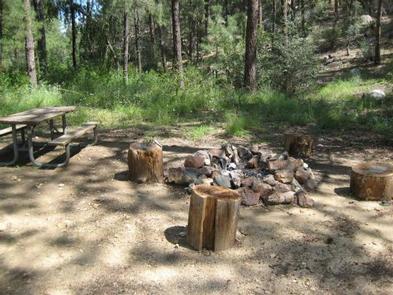
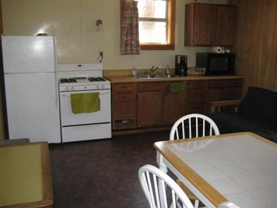
The kitchen has all the basic amenities including a sink, propane stove/oven, refrigerator, toaster, coffee maker, and table with five chairs. The bathroom has a flush toilet, sink, and shower. There is a fire pedestal grill, fire ring, and picnic table on site.
Although the cabin has several amenities, guests must also provide a few of their own supplies, including food, sleeping bags, linens, towels, dish soap, matches, first aid kit, and garbage bags. It is recommended that you carry a well prepared Emergency Kit for any emergency.
Natural Features
The nearby Castle Creek Wilderness is defined by rugged and diverse terrain ranging from lower elevations with saguaro cactus, palo verde, mesquite, jojoba, cat claw, and grasslands to higher elevations dominated by piñon pine and juniper.
Dense populations of mule deer and javelina inhabit this area, along with a few mountain lions, bobcats, black bears, coyotes, rabbits, foxes, skunks, and badgers. Snakes and lizards live here, and numerous birds soar overhead, including doves, quail, hawks, owls, ravens, jays, and many smaller species.
The area is rich in history, including early Native American inhabitants and later in the 1860s, home to horse thieves and rustled livestock. Evidence of historical mining activity abounds in this area, especially in the nearby community of Crown King.
Nearby Attractions
Horsethief Lookout Tower as well as Hazlett Hollow and Turney Gulch Campgrounds are in close proximity to the cabin.