
Directions
From Sandy, Oregon, travel east on Highway 26 for approximately 40 miles to Skyline Road (Road 42). Turn right on Skyline Road and travel south for 8.3 miles to the intersection of Forest Service Roads 42 and 57. Continue on Forest Service Road 42 for a quarter-mile. The Clackamas Lake Historic Ranger’s Cabin is on the left.
Maps are available online or for purchase by calling the Zigzag Ranger District.
Phone
503-630-5721
Activities
BIKING, BOATING, HISTORIC & CULTURAL SITE, CAMPING, FISHING, HIKING, VISITOR CENTER, WILDLIFE VIEWING, SWIMMING SITE
Keywords
CLCA,Clackamas Lake Guard Station,Clackamas Lake Ranger Station,Clackamas Lake Cabin,Clackamas Lake Historic,Clackamas Lake Ranger’s Cabin,Clackamas Lake Guard Cabin,MT. HOOD NF – FS
Related Link(s)
Overview
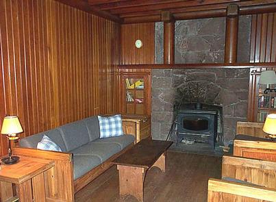
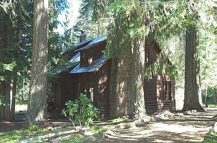
Clackamas Lake Historic Cabin gives campers an old-fashioned cabin experience with its well-preserved features, including a massive rock chimney, knot-free interior paneling and hand-wrought iron work. It provides access to a number of outdoor recreation opportunities as well as its namesake lake.
Recreation
Clackamas Lake is a great place for fishing, swimming and non-motorized boating. Anglers can expect a catch of cutthroat, brook, rainbow and some German brown trout. A variety of wildlife make its home in the area as well. Nearby, the 1,400-acre Timothy Lake provides opportunities for picnicking as well as water-related recreation, including the use of power boats.
Hiking, mountain biking and horseback riding are also enjoyed by visitors to the area. The 2.2-mile Miller Trail begins in the neighboring campground and connects trekkers to the lengthy but scenic Pacific Crest Trail, which extends more than 2,650 miles, from Canada to Mexico. Additional trails, to scenic Little Crater Lake and to the Mt. Jefferson Wilderness area, are also available in the area. A Northwest Forest Pass or Mount Hood Recreation day use fees are in effect at nearby trails and sites.
Facilities
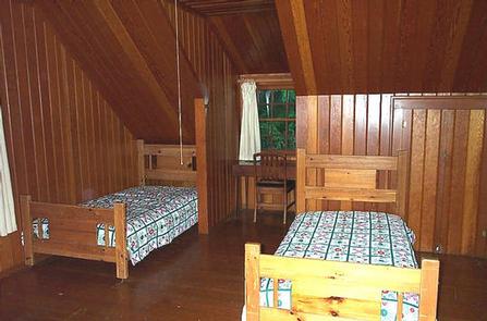
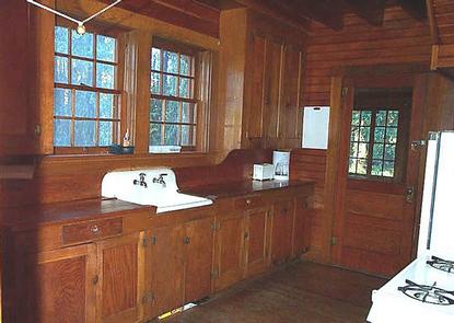
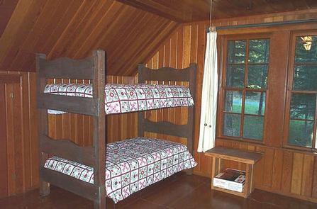
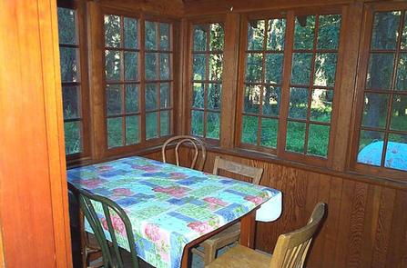
The 1,300 square-foot, two-story cabin has a living room, kitchen, dining area, sunroom, bathroom with flush toilets and a shower, and three bedrooms with beds and mattresses. The cabin can accommodate up to eight people. The kitchen is equipped with a propane cook stove and oven, refrigerator, cooking pots and pans, and cooking and eating utensils and dishes.
The cabin is heated by a fireplace insert in the living room. Firewood is provided. Hot and cold running water is always available. The cabin has propane lighting available from 8 a.m. to 10 a.m. and again from 6 p.m. to 10 p.m. Propane lanterns provide interior light outside of these hours. A rustic generator does not allow use of any plug-in electrical appliances, such as TVs, stereos, DVD players, computer, hair dryers, etc.
Guests will need to bring sleeping bags or bedding, towels and wash cloths, food and personal gear, as well as a flashlight or lantern for emergencies, a first aid kit, insect repellent, sunscreen and dish soap, among other necessities. Please bring garbage bags and clean the facility before leaving. This is a "Pack it in, Pack it out" site.
Guests can access the cabin by vehicle, as it is open from just before Memorial Day weekend through October each year. Snow conditions may impact travel. Guests are responsible for their own travel arrangements and safety.
Natural Features
This historically significant, two-story cabin was built by the Civilian Conservation Corps in 1933 to house workers. It is a classic example of the Forest Service rustic architectural style of Depression Era administration buildings. Across the road is the old District Ranger’s office, which is now a two-room visitor center.
The cabin is located a quarter-mile from the small, 3-acre Clackamas Lake and just 3 miles from the larger Timothy Lake, at an elevation of 3,400 feet. It is surrounded by tall trees and is part of a 4-acre compound and is listed on the National Register of Historic Places.
Nearby Attractions
The cabin is less than 40 miles from Mt. Hood, where a historic lookout provides scenic views of the snow-capped mountain. Hiking and year-round skiing is also available there.
The nearest store is in the town of Wapinitia, which is 15 miles away on Highway 26.