

Directions
From Dufur, Oregon, travel west on Valley Road for about 18 miles to the junction of Forest Service Roads 44 and 4430, at Billy Bob Sno-Park (the road may be plowed to the Sno-Park). Turn right on Forest Service Road 4430-120, then turn left and follow to the spur road 122. There is a gate that you will have to unlock (in winter months the gate is left open), then follow the 122 road to the end. The route is approximately 3 miles and is marked with orange and blue diamond shaped blazers. This route is not plowed, signed or patrolled. Forest Service Roads 44 and 4430 are closed from the junction of Forest Service Roads 44/4430 to Highway 35, from Dec. 15 through March 15, prohibiting motorized vehicles over 48 inches wide without a permit. During this time, visitors should park at Billy Bob Sno-Park and hike 3 miles to the lookout. A Northwest Forest Pass is required park at the Sno-Park. Maps are available online or for purchase by calling the Barlow Ranger District.
Phone
541 467-2291
Activities
CAMPING, HIKING, HUNTING, RANGER STATION, BIRDING, CROSS COUNTRY SKIING
Keywords
FBLO,Fivemile Lookout,FIVEMILE,FIVEMILE CABIN,MT. HOOD NF – FS
Related Link(s)
Overview
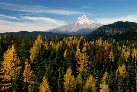
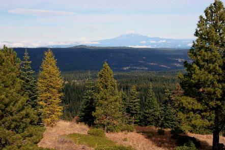
Fivemile Butte Lookout is available for reservation year-round. It provides stellar mountain views and access to a variety of outdoor recreation opportunities, including hiking, mountain biking and wildlife viewing. During the winter months, the lookout is popular among hunters and winter sports enthusiasts. In the winter the lookout can only be accessed by skiing, snowmobiling or snowshoeing up to 3 miles from a parking area at the Billy Bob Sno-Park. A permit is required to park and the trek takes about three to four hours. In the summer guests can drive directly to the lookout but will need a gate code once their reservation is made. Guests are responsible for their own travel arrangements and safety, and must bring several of their own amenities.
Recreation
In the summer months, visitors enjoy hiking, horseback riding and mountain biking in the area, as well as the gorgeous views from the lookout. The lookout is near Eightmile Creek and Eightmile Trail, which travels through and around a riparian area, old growth pine forests and meadows dotted with wildflowers.
The area is popular among winter sports enthusiasts as well, as the location provides access to numerous cross country skiing, snowshoeing and snowmobiling trails. It is a shared winter recreation area and lookout guests should expect other winter sports enthusiasts in the area.
Facilities
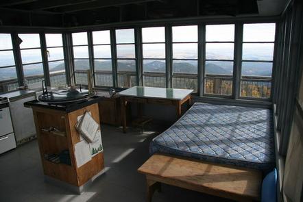
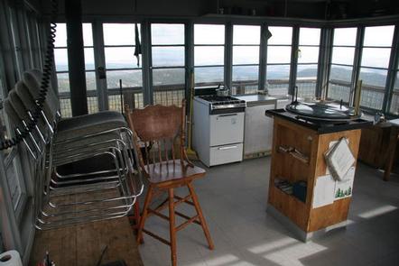
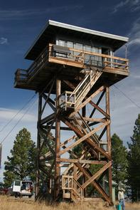
The cabin is atop a 40-foot tower and is surrounded by a wooden catwalk. The 14-by-14 room is furnished with a small bed, a wood stove for heating and a table and chairs. It has a propane cook stove and solar-powered lights. There is no water on-site. An outhouse with a vault toilet is located on the ground, as well as a shed stocked with firewood. A rope and pulley system is available to transport gear, as well as firewood, up and down the tower with ease. Guests will need to bring their own water for drinking, cooking and cleaning purposes, as well as their own sleeping bags/bedding, a flashlight or lantern for emergencies, first aid kit, washcloths and towels, dish soap and garbage bags. This is a “Pack it in, Pack it out” facility; guests will need to carry out all trash and clean the facility prior to leaving.
Natural Features
The lookout was originally a small cab on a 30-foot tower, established in the 1920s. In 1932, a standard lookout tower was built to replace the earlier lookout, but was destroyed by heavy snow in 1942. A non-typical lookout structure was rebuilt at the site in 1957.
The tower sits on Fivemile Butte, at an elevation of 4,627 feet. It is surrounded by ponderosa pine, Douglas fir and western hemlock forests. Numerous creeks run through the area. A variety of wildlife, including wild turkeys, grouse and blue jays, as well as deer, elk, coyotes, cougars and bears, frequent the area.