Directions
From Wisdom, MT, travel south on Highway 278 approximately 6 miles. If coming from Jackson, MT travel north on Highway 278 for approximately 12 miles. Turn west onto the Twin Lakes Road, follow for 8 miles, turn left Forest Road 945 continuing approximately 5 miles to Forest Road 183. Turn west onto Forest Road 183 for approximately 6 miles, turn northwest onto Forest Road 183A for approximately 1 mile. The cabin is located in Twin Lakes campground on the shores of the lake. Once you are in the campground turn left at the bulletin board. The cabin is located between Site #2 and Site #5. A map of the area may be necessary to reach the cabin and can be purchased by calling the Wisdom Ranger District. Snowfall prohibits convenient access to the cabin throughout most of the year. Guests must snowmobile, ski, snowshoe or hike up to 12 miles to the cabin during the winter and spring months from the end of the plowed road. The route is marked with orange diamond stakes in the ground.
Phone
406-689-3243
Activities
BIKING, BOATING, CAMPING, FISHING, HIKING, WINTER SPORTS, WILDLIFE VIEWING
Keywords
TWLC,TWIN LAKES,TWIN,LAKE CABIN,BEAVERHEAD-DEERLODGE NF -FS
Related Link(s)
Overview
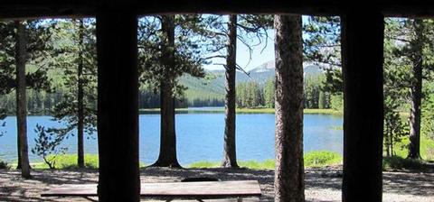
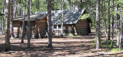
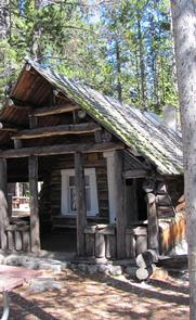
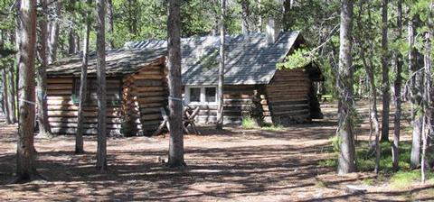
Twin Lakes Cabin is located in a scenic evergreen forest in the Beaverhead Mountains of western Montana. It was built in the 1920s to provide housing for trail crews, smoke chasers, timber cruisers and grazing inspectors who worked in the area. Guests have access to a number of recreational opportunities, including hiking and mountain biking in the summer and fall, and snowmobiling, snowshoeing and cross-country skiing during the winter. The cabin is accessible by vehicle during the summer months, and until the snow closes the road. Guests may need to hike, snowmobile, ski or snowshoe up to 12 miles when the access road is closed. The cabin is equipped with a variety of amenities to provide an optimal outdoor experience; however, guests need to bring some of their own supplies and gear.
Recreation
A variety of hiking, mountain biking and horseback riding trails exist in the area, including the Big Lake Creek Trail, which traverses four miles of terrain surrounding the lake. The nearby trails also provide access to the Continental Divide National Scenic Trail. During winter months, the trails are popular for snowmobiling, cross country skiing and snowshoeing. Visitors should be prepared for unexpected avalanches. Fishing and non-motorized boating are enjoyed by visitors to Twin Lakes. Anglers might see a variety of trout, as well as arctic grayling and mountain whitefish. Power boats are limited to electric motors only on the lake.
Facilities
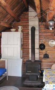
The wood-frame, one-room cabin sleeps up to four people and comes equipped with one bunk bed with mattresses and two folding cots. Other amenities include a wood-burning
stove, propane cook stove, table and chairs, cupboard space, a food storage box, basic cooking and eating utensils, cookware, a propane lantern, axe, shovel, bucket and
cleaning equipment.
A wood stove is available for heat, and firewood and an axe are provided from September 16-June 15. You will need to provide your own firewood from June 16-September 15. An outhouse with vault toilet is located nearby.
The cabin has no electricity or running water. Guests will need to bring their own water for drinking, cooking and cleaning during the fall, winter and spring. Water is available from June to Sepember from a hand pump located near the cabin. Water can be taken from the mountain lake
or streams, but it must be treated prior to use.
Fuel is not provided for the cook stove or lantern, so guests need to bring 16-ounce propane canisters. Other items to bring include bedding, food, toilet paper,
towels, matches, flashlights, garbage bags and maps, among other necessities. Guests are required to carry out all trash and food and clean the cabin prior to leaving.
Natural Features
The cabin is located in a heavily wooded area at the base of Squaw and Jumbo peaks on the shore of the 75-acre Twin Lakes. It is situated at an elevation of about 7,200 feet in the Beaverhead Mountains, a subrange of the Bitterroot Range that divides Montana and the neighboring state of Idaho.
Extensive conifer forests provide habitat for a large elk herd that winters in Idaho and summers in Montana. Marshy glacial valleys in the area constitute some of the best moose habitat in the state. Other wildlife in the area includes mountain goats, bighorn sheep, lynx, marten, deer and black bears (learn more about bear safety).


