

Directions
From La Grande, Oregon: travel east on Highway 203 to Union. From Union, follow Highway 203 to Medical Springs. Go straight through Medical Springs and take County Road 71 until it turns into Forest Service Road (FSR) 67. Follow until you reach the FSR 77 junction. Take FSR 77 and turn left on the FSR 7755 junction. Go straight on FSR 7755 approximately 2 miles past the Two Color Campground to the cabin, which is on the right.
Phone
541-963-7186
Activities
CAMPING, FISHING, WILDLIFE VIEWING
Keywords
TCGS,Two Color Cabin,Two Color Guard Station,Two Color Forest Cabin,Eagle Creek Cabin,Two Color,WALLOWA-WHITMAN NF – FS
Related Link(s)
Overview
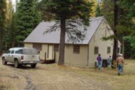
The Civilian Conservation Corps originally constructed the Two Color Guard Station in the 1930s for use as crew quarters and bunkhouse. The original building was removed in 1976. The current guard station was built in 1959.
Two Color Guard Station is open June through October. Guests can drive to it except after significant snowfall, when it’s only accessible by snowmobile. Guests staying in the later part of the season are encouraged to bring extra supplies to ensure a comfortable and enjoyable stay.
Recreation
The cabin is near the Main Eagle Trailhead, which is southern portal into the Eagle Cap Wilderness (2 miles away). This trail is open to hikers and horseback riders.
Forest Road 7755 is one of the designated roads on the snowmobile route south of the Eagle Cap Wilderness, and it can be used for snowmobiling, cross-country skiing and snowshoeing. Two Color Guard Station is the end of the groomed trail. Other open and closed forest roads are available for winter time exploring, but snowmobiles are prohibited within the Eagle Cap Wilderness.
Anglers can fish for rainbow trout in Eagle Creek, just 150 feet from the cabin’s front door.
Facilities
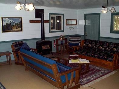
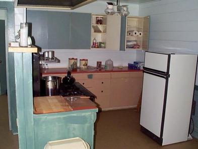
The cabin is comfortably furnished with a table and chairs, couches, and enough beds to accommodate 12 people. Bedding and linens are not provided. Other amenities include propane lights, a propane cook stove and oven, refrigerator and heating stove. Cookware, place settings and most cooking utensils are provided.
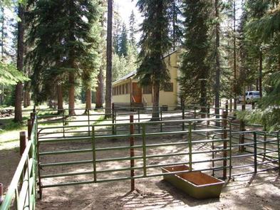
Outside the cabin is a picnic table and a corral large enough for several stock animals. The outside vault toilet is accessible.
Water is not available, and guests must bring plenty for drinking, cooking and washing. Potable drinking water may be obtained approximately three miles away at Tamarack Campground. Guests need to bring garbage bags for packing out trash, and the cabin must be cleaned before leaving.
Bedding, towels, dish soap and emergency items like flashlights and first aid kits are not provided. Click here for additional cabin details.
The price listed is per night with a maximum of four occupants. An additional fee of $10.00 per person per night is charged for each occupant in excess of four, with a maximum of twelve occupants. Fees are used directly for the maintenance and preservation of the guard station.
Natural Features
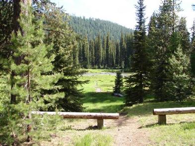
Outside the cabin, the crystal clear waters of the Wild and Scenic Eagle Creek work their way through the mountains to the valley floor in a series of small waterfalls and whitewater rapids. The landscape features subalpine firs and white bark pine as well as meadows that burst with colorful wildflowers. Guests will find blue-green pools and dramatic rock formations scattered along the creek’s path.
Two Color Guard Station is just a short distance away from the Eagle Cap Wilderness. This wilderness is characterized by high alpine lakes and meadows, bare granite peaks and ridges, and U-shaped glaciated valleys.
Nearby Attractions
Within 10 miles there are opportunities for berry picking, hiking, horseback riding, mountain biking and hunting.