

Directions
From the south: From Hwy 12 take Forest Road 274 north for approximately 11 miles to Forest Road 6429 tturn right on 6479 just past Whitetail Campground. Go approximately .5 mies on road 6429 to the Hunter Springs Cabin turn off on the right. and the sign pointing to the Hunters Spring Cabin. From the North: From Utica, MT take the county road west out of Utica which is county road 1 and go about 13 miles to a junction. At the junction, go straight or left toward South Fork Judith Forest Road 487 and follow the road all the way to the Spring Creek junction. Turn Left onto Spring Creek Road #274 and follow it to the Bear Park Road #6429. Turn left and go just past the spring to the left and the gate will be on the right.
Phone
406-236-5511 OR 406-566-2292
Activities
BIKING, CAMPING, FISHING, HIKING, HUNTING, OFF HIGHWAY VEHICLE, PICNICKING, WILDLIFE VIEWING, PHOTOGRAPHY, SNOWMOBILE, MOUNTAIN BIKING, BIRDING, CROSS COUNTRY SKIING, BACKPACKING, ARCHERY, SLEDDING, SNOWMOBILE TRAILS, WOOD CUTTING
Keywords
HUNS,HUNTERS,SPRINGS,LEWIS AND CLARK NF – FS
Related Link(s)
Overview
Hunters Spring provides a serene escape in the mountains of central Montana. The cabin is open year-round and is secured with a combination lock. It is a prime destination for hunting, hiking, off-highway vehicle riding, snowmobiling and cross country skiing enthusiasts. The cabin is a great launching point for whatever type of recreation you wish to do. Hunters Spring Cabin is a must on your next destination plans! Summer access is via a gravel Forest Service 274 up to the cabin. The combination for the cabin will also open the gate to the driveway of the cabin. Access in the winter months is by snowmobile, skis or snowshoes only. The road is not plowed and not open to wheeled vehicles between December 1 – (generally) April 15. Please contact Belt Office at 406-236-55111 or the Harlowton Office at 406-632-4391 for more information on road conditions.
Recreation
Open year-round, the surrounding area offers outdoor recreation opportunities including hunting, hiking, off-highway vehicle riding, cross country skiing, snowmobiling and snowshoeing.
Facilities
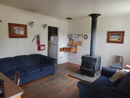
The rustic two-story cabin sleeps up to eight guests in three roomy bedrooms. The kitchen is outfitted with a propane cook stove, refrigerator and a wood stove for heat. The dining room is furnished with a table and chairs. Firewood is provided for the wood stove, cooking pots and utensils are on hand in the kitchen. Dogs are not permitted inside the cabin. No water, electricity or sewer is provided. Guests should bring plenty of water, bedding, food, warm clothing, toilet paper, flashlights, matches, and other basic camping items. (Click here for more cabin details.)
Natural Features
Hunters Spring is located in the Little Belt Mountains near Whitetail Creek at an altitude of about 6,400 feet. Lodgepole pine and Douglas fir can be found in the area, and deer and elk are common.
Nearby Attractions
The nearest towns are Harlowton and White Sulphur Springs. Both are about an hour’s drive from the cabin.