
Directions
From Lewistown, drive west on Montana Highway 200/US 87 for about 8 miles. Turn left (south) on Crystal Lake Road. Continue south, following the well-signed directions to the lake for 20 miles. At the "T" junction, turn left and continue on to Crystal Lake. The last 6 miles is paved and mostly a single lane.
On December 1, the paved section is gated, and access beyond the gate is by snowmobile, skis, snowshoes or hiking only.
Phone
406-566-2292 OR 406-236-5511
Activities
CAMPING, FISHING, HIKING, WILDLIFE VIEWING, PHOTOGRAPHY, CANOEING, CROSS COUNTRY SKIING
Keywords
CRYC,CRYSTAL,LAKE,LEWIS AND CLARK NF – FS
Related Link(s)
Overview
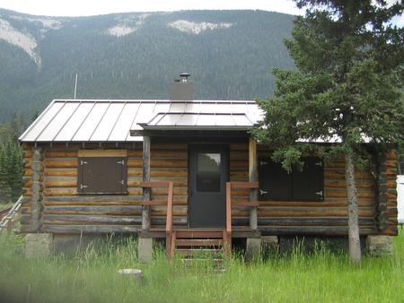
Crystal Lake Cabin provides sweeping views of Crystal Lake in the heart of the Big Snowy Mountains of Central Montana. Located about 20 miles south of Lewistown, the cabin adjoins Crystal Lake Campground, providing conveniences like a picnic area and boat ramp for non-motorized boats. Recreation opportunities abound, including floating, fishing, canoeing and hiking.
Access from December 1 through June 15 is by snowshoe, snowmobile, cross country skiing or hiking for 6 miles.
Recreation
The Ice Caves Trail leads hikers to the ridgetop of the Big Snowy Mountains, where it intersects with the Crystal Cascades Trail Bypass. The Lake Loop Trail trailhead, located at the north end of the Crystal Lake Campground, takes hikers to Grand View Trail Junction and additional ridgetop views. Both the Ice Caves Trail and Grand View Trail may be impacted by winter snow as late as the first part of July.
The lake freezes over and ice fishing is possible if the ice is thin enough for fish to survive. In summer months, the lake is stocked with rainbow trout. Kayaking and canoeing is popular.
Facilities
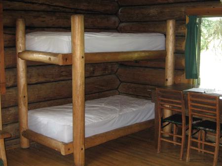
The one-room cabin accommodates up to six guests. Beds with mattresses, a cooking stove and a wood stove for heat is included. Firewood is provided for the wood stove, and guests are asked to restock the wood box in the cabin prior to departure. A vault toilet is located outside and the cabin is furnished with cooking pots and eating utensils. Propane lights are provided but no electricity is available.
Guests should plan to bring plenty of water, bedding, food, a cooler, toilet paper, garbage bags and other personal necessities. (Click here for more cabin details.)
Natural Features
The cabin sits near the shores of Crystal Lake. The beautiful lake spans 45 acres at an elevation of 5,700 feet. With a maximum depth of 15 feet, the lake seeps fresh water through a porous limestone bottom. The lake generally freezes in the winter.
The Big Snowy Mountains, lush with mixed conifers, rise up from the lake, providing spectacular views. The highest peaks in the mountain range reach 8,600 feet.
Nearby Attractions
The nearest grocery stores are in Lewistown and Moore.