

Directions
Access #1: From I-90, take Exit #43 (Kingston) and drive 24 miles north on Forest Highway 9 (two lane paved highway) to the Prichard Junction. Continue on Forest Road 208 for 28 miles to the end of the pavement and the start of Forest Road 6310 (a gravel road with rocks and potholes). Travel 7 miles on road 6310 to the Magee Ranger’s Cabin. The approximate travel time from Coeur d’Alene on this route is 2 hours.
Access #2: From the Ranger Station in Coeur d’Alene, drive east on County Road #268 (Fernan Lakeshore road) for 5 miles; this road enters the Cd’Alene National Forest and climbs up into the mountains on Forest Road #268. Forest Road #268 is a paved two lane road that you will follow for 7 miles to Fernan Saddle. Continue on paved road which is Forest Road #612 (paved then graveled good quality two lane) and follow it 11 miles to Forest Road #209 past Honeysuckle Campground. Cross bridge and turn right (south) on Road #209 for 5 miles to its junction with Forest Road #422. Turn left (north) and travel 14 miles on Road #422 toward Magee. Road 422 is a fair quality graveled road that is mostly two lanes but in places narrows to 1-1/2 lanes with turnouts; use caution and go slow. The road is suitable for automobiles. Turn right at Forest Road #6310, Magee Cabin will be on your left. Travel time from Coeur d’Alene is around 1-3/4 hours.
Phone
208-664-2318
Activities
BIKING, HISTORIC & CULTURAL SITE, CAMPING, FISHING, HIKING, WATER SPORTS, WILDLIFE VIEWING
Keywords
MRCA,MAGEE CABIN,MAGEE RANGER STATION,MAGEE WORK CENTER,IDAHO PANHANDLE NF – FS
Related Link(s)
Overview
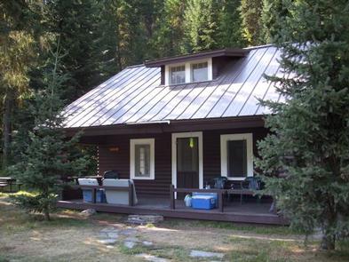
The Magee Ranger’s Cabin is a fully furnished 2-story cabin in the center of the Coeur d’Alene River Ranger District. Guests can imagine themselves as forest rangers when sleeping in the old ranger’s quarters, and enjoying the superb views and convenient access to prime recreation trails.
The Magee Cabin was constructed in 1922 as living quarters for the Magee District Ranger. The cabin along with several buildings at the site are on the National Register of Historic Places. These buildings may occasionally be occupied as temporary housing for Forest Service employees working in the vicinity.
Recreation
Nearby trails include the Independence Creek Trail System, with 34 miles of trails suitable for hiking, motorcycle riding, horseback riding and mountain biking.
Teepee Creek is a tributary of Idaho’s South Fork Salmon River and is open to fly fishing with popular catches including cutthroat trout and brook trout.
Facilities
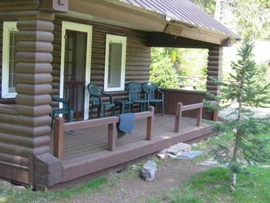
The log cabin has a front porch and is located near a public picnic area. It sleeps six guests, with a full-size bed downstairs and four single beds upstairs. Amenities include drinking water, propane stove, refrigerator and heater. Two portable propane lanterns are available, but guests should bring their own propane. Items to bring include propane for lanterns, bedding, flashlights, food, a first aid kit, matches, insect repellent, towels, dish soap, dish towels and washcloths. Visitors should also bring a splitting maul, axe or bow saw for collecting firewood, plus charcoal and lighter fluid to start campfires. There is a shower and toilet available in the warehouse that is approximately 200 ft. from the rental. A detailed walking map is available in the cabin.
Natural Features
Magee sits at an elevation of 3,000 feet along the Teepee Creek in the heart of the Coeur d’Alene Mountains.
Nearby Attractions
The nearest telephone is about 25 miles away and the nearest grocery store is about 32 miles away in Prichard, ID.