AIRPORT BEACH SHELTER, TX Campground Reservation, Info, Images, Map, Directions

AIRPORT BEACH SHELTER, Texas Campground Images, Info & Reservations

Directions

From I-35 take Lake Shore Drive exit (Exit 339) and drive west to Steinbeck Bend Road. Turn right and proceed to second stop light. At intersection with FM1637 (China Spring Highway) turn right. Go to next stop light (Flat Rock Road). Turn left and drive approximately 1 mile to Skeet Eason Road. Turn left and drive about a 1/2 mile. Airport Beach Park is on the second road to the right.

Phone

254-756-5359

Activities

BOATING, CAMPING, FISHING, SWIMMING

Keywords

ABEA,WACO LAKE

Related Link(s)

Rec Area Info & Images

Texas State Tourism

Texas State Road Conditions

Overview

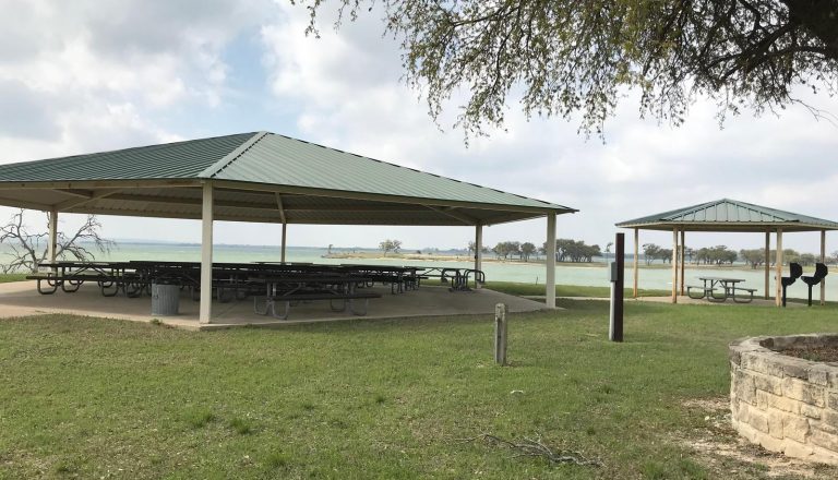
Airport Beach Shelter, located on one of Waco Lake’s sandy beaches, is ideal for families and friends to enjoy picnicking, sightseeing and water activities, all while staying within the Waco city limits.

Recreation

The main lake shoreline has a large amount of submerged timber, which typically holds fish year-round. Anglers will find plenty of catfish, crappie, large and smallmouth bass as well as sunfish.

A swimming beach, boat ramp and dock all help visitors enjoy the lake.

Facilities

The accessible shelter fits 110 guests, and a picnic area with grills and tables makes the park ideal for large parties and family functions.

Natural Features

Airport Beach Park is located on the North Shore of Waco Lake, about a quarter-mile west of the dam. The lake is primarily fed by the Bosque River, which runs for 115 miles through central Texas.

Nearby Attractions

Waco Lake Wetlands educational tours take visitors through a six-acre nursery of aquatic plants and more than 130 species of birds. A zoo is also located nearby.

Reservation

More from CampingHiking.net:

FLOATING MILL PARK, Tennessee Campground Images, Info & Reservations

Directions From I-40, take exit 273. Merge onto US-56 south and continue for 3.5 miles to Floating Mill Road. After about a mile, turn right to stay on Floating Mill Road, and follow signs into the campground. Phone 931-858-4845 Activities BOATING, CAMPING, FISHING, HIKING, HUNTING, WATER SPORTS, DAY USE AREA,

CEDAR SPRINGS CAMPGROUND (WA), Washington Campground Images, Info & Reservations

Directions From Naches, take Highway 410 to milepost 88.4. Turn left on Bumping Lake Road and go 0.6 miles to the campground. Phone 541-338-7869 Activities CAMPING, FISHING, HIKING Keywords CESP,Bumping River,Naches,OKANOGAN – WENATCHEE NF -FS,CEDAR SPRINGS,CEDAR SPRINGS CAMPGROUND Related Link(s) Rec Area Info & Images Forest Service Concessionaire Washington State

DEFEATED CREEK PARK, Tennessee Campground Images, Info & Reservations

Directions From Carthage, Tennessee, take SR-25 west for 4 miles. Turn north on SR-80, then east on SR-85. Follow signs to campground. Phone 615-774-3141 Activities BIKING, BOATING, CAMPING, INTERPRETIVE PROGRAMS, FISHING, HIKING, WILDERNESS, SWIMMING SITE, ENVIRONMENTAL EDUCATION, PHOTOGRAPHY, PADDLING, SWIMMING, PADDLE BOATING, WATER ACTIVITIES, KAYAKING, STAR GAZING, WATER ACCESS, WATER

CHOCTAW LAKE, Mississippi Campground Images, Info & Reservations

Directions From Jackson, Mississippi, travel Highway 25 north toward Starkville. Turn onto Highway 15 north toward Ackerman, Mississippi, and travel 11 miles to Forest Road 967 to the campground. Phone 662-285-3264 Activities BIKING, BOATING, CAMPING, FISHING, HIKING, WILDLIFE VIEWING, SWIMMING SITE Keywords CHOL,NFs IN MISSISSIPPI – FS Related Link(s) Rec

SANDBEACH, Oregon Campground Images, Info & Reservations

Directions To Access from Pacific City, OR: From Highway 101 take Brooten Road into Pacific City. Turn left onto Pacific Ave at four way stop. Drive over the bridge and turn right onto Cape Kiwanda Dr (2.3 miles). Veer left when it changes to Sandlake Road and stay on Sandlake