
Directions
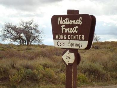
From Grand Junction, head south on Highway 50. Take a right on County Road 141 heading south for 14.5 miles. Make a sharp left on Divide Road. This road is not marked, but prior to turn, a sign reads "National Forest Access Divide Road, Uncompahgre Plateau." Follow this road for 19.6 miles and take a left on Forest Road 406 (where a sign says "Cold Springs Work Center"). Go a quarter-mile and then turn right on 406.1A. Cabin is a half-mile after turn on the left.
Have combination lock handy to enter the gate. Parking is in front of the cabin.
Phone
970-242-8211
Activities
BIKING, CAMPING, FISHING, HIKING, HUNTING, WILDLIFE VIEWING
Keywords
Cabin C at Cold Springs Ranger Station,Back Cabin at Cold Springs Ranger Station,Uncompahgre National forest,Grand Valley Ranger District,OAK CABIN (CO),Oak Cabin
Related Link(s)
Colorado State Road Conditions
Overview
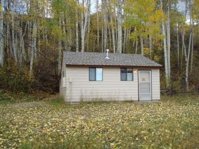
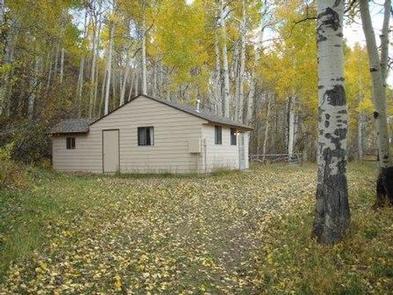
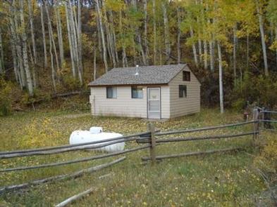
Oak Cabin attracts outdoor enthusiasts ranging from mountain bikers to hunters to those who love riding off-road. The somewhat remote, semi-rustic cabin provides an ideal resting spot among aspen trees and mountain scenery.
One of three cabins in the area, Oak Cabin was built in the 1930s for use by Forest Service employees at the Cold Springs Work Center. One of the other cabins may be occupied by Forest Service personnel. The area is easily accessed by vehicles, but a 4WD may be required in October, depending on weather conditions.
Recreation
The North Uncompahgre boasts an extensive ATV trail system known as the Divide Forks ATV complex. Over 50 miles of trails can be explored here.
Mountain bikers make use of the popular Tabaguache Trail System, and in fall, hunters frequent the area. Hiking and horseback riding are also enjoyable activities.
Facilities
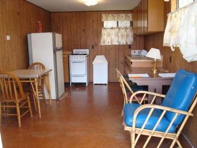
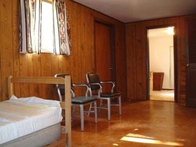
The single-story cabin, which sleeps four guests, has a small grassy lawn shaded by aspen trees. Furnishings include two twin-size beds in a bedroom, one queen sofa sleeper in the living room and one bathroom with a shower and flush toilet.
The kitchen has a propane stove and refrigerator, plus basic cooking and eating utensils like plates, knives, forks and pots. Cleaning supplies are provided.
Drinking water is supplied but the cabin has no electricity. Guests should bring propane lanterns, matches, bedding, toilet paper, dish towels, warm clothing, paper towels, and tools for gathering and cutting firewood. Click here for more cabin details.
No RV’s, campers, or tents allowed.
Please conserve water. Water can be limited at times. Bring back-up drinking water.
Natural Features
Oak Cabin sits in a field with scattered aspen and mountain shrub vegetation on the north end of the Uncompahre National Forest. At 9,000 feet, the area offers crisp mountain air, mild days and chilly nights.
Black bears, mountain lions, marmots and deer are among the wild inhabitants. Please be aware of bear safety.
Nearby Attractions
The nearest grocery store is in Grand Junction, which is 44 miles from the cabin.
Anglers looking for lake fishing can head to Big Creek Reservoir, about 14 miles away.