DAVENPORT CAMPGROUND, CO Campground Reservation, Info, Images, Map, Directions

DAVENPORT CAMPGROUND, Colorado Campground Images, Info & Reservations

Listen

Directions

From Pueblo, go 25 miles south on I-25 to Exit 74. Go west 25 miles on State Highway 165 to Forest Road 382. Turn right onto Forest Road 382 and travel about 2 miles until the road dead ends at the campground.

Phone

FOR RESERVATIONS CALL (877) 444-6777, FOR OTHER NON REAL TIME INFORMATION, CALL (719) 269-8500.

Activities

BIKING, BOATING, CAMPING, FISHING, HIKING, DAY USE AREA

Keywords

DAVENPORT CAMPGROUND (CO)

Related Link(s)

Rec Area Info & Images

Colorado State Tourism

Forest Service Concessionaire

Colorado State Road Conditions

Overview

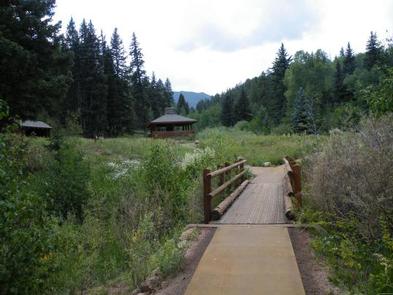
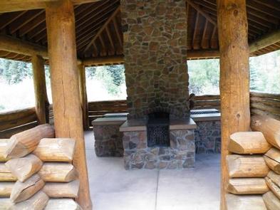
Davenport Campground was one of the first Forest Service campgrounds, and is near the now-abandoned Squirrel Creek Campground, the very first Forest Service campground in the country. In 2010, Davenport was rebuilt to evoke the original 1920s design. Adirondack shelters and a common cooking shelter with stone fireplaces were built and old-style log picnic tables add to the historic character of this campground.

The campground offers access to an array of hiking, mountain biking, motorcycle and off-road vehicle trails.

Recreation

The 4.5-mile Squirrel Creek Trail is open to hiking, biking, horseback riding and motorcycle riding. This trail meets the original Squirrel Creek Campground site where a major flood, in 1947, washed out the never-reopened road and campground. Silver Circle, Second Mace, and South Creek Trails can be accessed nearby, too.

Anglers enjoy casting for brook trout in Squirrel Creek.

Facilities

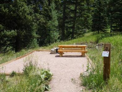
The campground offers single-family sites for tent camping only. Most of these are reached by walking on short foot trails to the sites from common parking areas. Some sites are accessible, and three sites have log Adirondack shelters. Each site is equipped with a picnic table, campfire ring and grill. Accessible vault toilets and trash collection are provided.

Natural Features

The campground sits in a grassy meadow surrounded by aspen and spruce trees at an elevation of 8,500 feet. Squirrel Creek runs alongside this scenic facility in the Wet Mountains of southern Colorado.

Nearby Attractions

Bishop’s Castle, a replica of a medieval castle, is about 2 miles from the campground, just off Highway 165. The always-in-progress structure is an interesting display of labor-intensive masonry and intricate wrought ironwork.

Beautiful Lake Isabel is less than 10 miles away. Visitors enjoy canoeing, kayaking and fishing in the stocked lake. Several mountain trails weave through the area.

Pueblo Mountain Park in Beulah Valley is about 7 miles east. This scenic park offers hiking trails, educational programs and a stone labyrinth.

Reservation

More from CampingHiking.net:

INDIAN FLATS CABIN, Montana Campground Images, Info & Reservations

Listen Directions Indian Flats Cabin is located 40 miles northeast of Helena. Take Highway 280 east from Helena. Several miles after crossing the Missouri River, you will come to the small community of York. Turn left at the York Bar and proceed 5 miles to the smaller community of Nelson,

AUNTS CREEK, Missouri Campground Images, Info & Reservations

Listen Directions From Branson, Missouri, take Highway 13 south for about 4 miles. Turn west onto Highway 00 and continue for nearly 3 miles to the campground. Phone 417-739-2792 Activities BIKING, BOATING, CAMPING, FISHING, HIKING, PICNICKING, WATER SPORTS, WILDLIFE VIEWING, DAY USE AREA, SWIMMING SITE, PHOTOGRAPHY, SWIMMING, RANGER STATION, WATER

CLEAR LAKE CABIN LOOKOUT, Oregon Campground Images, Info & Reservations

Listen Directions Access begins at the junction of Highway 26 and Forest Service Road 42, 12 miles south of Government Camp, Oregon, at the Skyline Sno-Park. Guests must park and the Sno-Park and ski, snowshoe or snowmobile to the facility. From the parking area, proceed on Forest Service Road 42

LAVA LAKE CAMPGROUND, Oregon Campground Images, Info & Reservations

Listen Directions From Bend, travel 38.4 miles southwest on Cascade Lakes Hwy (46), then 1.0 miles east on Forest Road 4600 500. Phone 541-323-1746 Activities CAMPING Keywords Related Link(s) Rec Area Info & Images Oregon State Tourism Oregon State Road Conditions Overview Lava Lake Campground is located along the Cascade

PANTHER FLAT CAMPGROUND, California Campground Images, Info & Reservations

Listen Directions From Highway 101 north of Crescent City, California, take highway 199 east for 16 miles to the campground. Phone 707-457-3131 Activities CAMPING, FISHING, SWIMMING SITE Keywords PANF,SIX RIVERS NF -FS Related Link(s) Rec Area Info & Images California State Tourism California State Road Conditions Overview Panther Flat Campground

DOGWOOD DAY USE, Utah Campground Images, Info & Reservations

Listen Directions Take exit 301 off I-15. Turn east and travel 6 miles on 7200 South to the mouth of Big Cottonwood Canyon. Travel 2 miles up Big Cottonwood Canyon to picnic area. Phone SALT LAKE RANGER DISTRICT OFFICE 801-733-2660 OR UTAH RECREATION COMPANY 385-273-1100 Activities BIKING, CLIMBING, CAMPING, FISHING,