
Directions
From the intersection of U.S. Highway 2 and Forest Highway 13 (25 miles west of Manistique or 14 miles east of Rapid River) , drive north 19 miles on FH13 to County Rad 440. Turn right (east) on CR440 and drive about 3 miles to FR2082. Turn left (north) and drive to cabin.
Phone
906-474-6442 OR 906-387-2512
Activities
BIKING, BOATING, CAMPING, FISHING, HIKING, HORSEBACK RIDING, WINTER SPORTS
Keywords
Related Link(s)
Michigan State Road Conditions
Overview
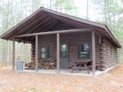
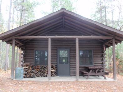
Tom’s Lake Cabin was built in 1991 and will accommodate up to eight people. The cabin is situated on a small knoll overlooking Tom’s Lake, a 23 acre lake in the heart of the Hiawatha National Forest.
Recreation
There are several hiking, biking, and horseback riding trails within a few miles from the cabin, including the Ironjaw semi-primitive area and the Pine Marten Run trail system offering 26 miles of trail. For the winter enthusiast, snowmobile trails can be found nearby, and the Pine Marten Run trail is frequently used for snowshoeing and cross-country skiing (although the trail is not groomed). Those trying their hand at fishing on the lake should note that boat access is carry-in only.
Facilities
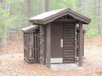
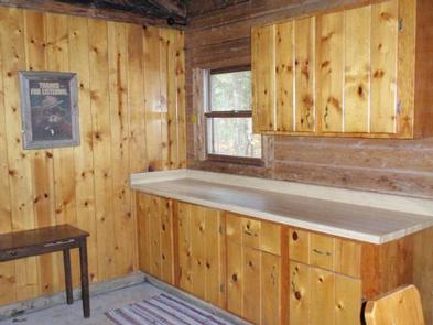
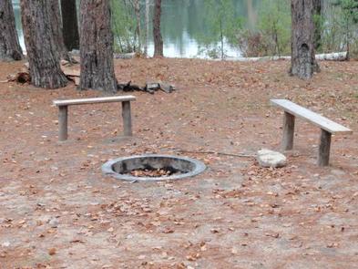
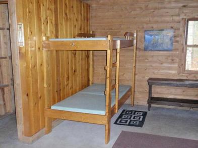
The cabin has a wood stove and firewood is provided in addition to the pedestal grill and fire pit outside. The cabin does not have modern bathroom facilities or electricity. There is a hand pump for drinking water just outside the cabin and a pit toilet behind the cabin. The cabin is furnished with four twin bunk beds with mattresses and seating for eight. You should plan to bring all your own camping equipment including camp stove, dishes, cooking and eating utensils, toilet paper, water containers, lanterns, flashlights, bedding and pillows. There is a gate at the entry road for your use. You can close it if you wish for privacy, but we ask that you don’t lock it in the event we need to get in for routine maintenance. We will leave it the way we found it. During the winter months, the 1/4 mile road into the cabin is not plowed. One must park in the parking lot provided along Co. Rd. 440 and walk, ski, or snowmobile in.
Natural Features
Tom’s Lake Cabin is nestled adjacent to Tom’s Lake and is ideal for swimming and fishing. Anglers will enjoy a day on the lake in search of largemouth bass and bluegill. After a day fishing and swimming, settle in for a wonderful campfire overlooking the lake and relax around the outdoor fire pit lined with a few benches. The Hiawatha National Forest is rich in wildlife, which includes 312 species that live within the Hiawatha National Forest region including whitetail deer, black bear, grey wolves, coyote, eagles, hawks, and rabbits. Over 250 species of birds use the Hiawatha, either when migrating through the area, as summer or winter range, or as permanent residents.
Nearby Attractions
The cabin is within a short commute of the Big Island Lake Wilderness with its 23 small lakes and portages to challenge the canoeist. The nationally-designated Wild and Scenic Indian River is also nearby, and its 51 miles offer outstanding canoeing and fishing opportunities.
Groceries, gasoline, fishing, camping supplies, boat rentals, ice, MDNR licenses, deli, and restaurants are available on Highway 13.