HALF MOON LAKE CAMPGROUND, WY Campground Reservation, Info, Images, Map, Directions

HALF MOON LAKE CAMPGROUND, Wyoming Campground Images, Info & Reservations

Listen

Directions

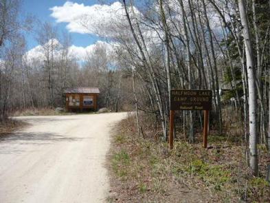
To reach the campground from Pinedale, drive to the east side of town and turn northeast onto the Fremont Lake road, passing the Pinedale Ranger District Office. Continue straight on the main road for approximately 10 miles to Half Moon Lake Road. Turn right onto road and continue for approximately two miles to campground access road.

Phone

(307)367-4326

Activities

BIKING, BOATING, CLIMBING, CAMPING, HIKING, WATER SPORTS

Keywords

Related Link(s)

Rec Area Info & Images

Overview

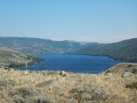
Half Moon Lake campground is situated just off the northeast shore of Half Moon Lake at an elevation of 7,600 feet in the Bridger-Teton National Forest, Wyoming.

Recreation

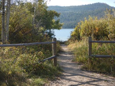
This lake provides many recreational activities. Anglers enjoy fishing for rainbow trout, brown trout, lake trout and other various species of fish native to the area. Visitors also enjoy water sports such as boating, swimming, canoeing and paddle boarding. Two miles down the gravel road is an excellent hiking trail for users of all abilities.

Facilities

This campground offers 17 sites; three of these provide direct lake access. Each site is well screened by willows and equipped with a picnic table and a fire ring. There are two vault toilets within the campground. Approximately 1/2 mile down the main road is the boat launch site, with a dock and additional vault toilets. No drinking water is available. Proper food storage is required.

Natural Features

Half Moon Lake was created by glacial movements and is now surrounded by the foot hills of the Wind River Mountains. Along the lakeshore and the hillsides you will find lodgepole pine, Douglas-fir and aspen stands interspersed with sagebrush and rocky outcroppings.

Nearby Attractions

The Museum of the Mountain Man, located in Pinedale, features a large collection of Rocky Mountain fur trade artifacts, Native American displays, as well as history of the settlement of Sublette County. In July look for the annual Green River Rendezvous. For more information please see the Sublette County Chamber of Commerce or pinedaleonline.com.

Reservation

More from CampingHiking.net:

ALTAMONT, Utah Campground Images, Info & Reservations

Listen Directions From Salt Lake City, Utah, travel south on I-15 to Alpine-Highland exit 284. Travel east on Highway 92 approximately 13 miles through American Fork Canyon, then 3 miles south on the Alpine Loop Scenic Byway. Campground is on the left. Phone PLEASANT GROVE RANGER DISTRICT 801-785-3563 OR UTAH

PRAIRIE CAMPGROUND, Oregon Campground Images, Info & Reservations

Listen Directions From Bend, OR: Travel about 23.5 miles south on Highway 97 then 3 miles east on County Road 21 to the Prairie campground sign. Follow the short paved road to the campground entrance. Phone 541-383-5300 Activities CAMPING Keywords Related Link(s) Rec Area Info & Images Oregon State Road

MINGUS RANCH, Colorado Campground Images, Info & Reservations

Listen Directions From Pueblo, CO take State Highway 96 approximately 30 miles to the junction of State Highway 165. Travel south on SH 165 for 9 miles. Turn left (east) onto Forest Service Road 383 (Ditch Creek Rd.) and continue 1.5 miles. The two story cabin is on the right.

HAZELTON RECREATION AREA, North Dakota Campground Images, Info & Reservations

Listen Directions From Bismarck, ND, take University Drive south (road becomes Highway 1804). Continue 25 miles south. Recreation area will be on the right side of the road. Phone 701-255-0015. FOR RESERVATIONS, PLEASE CALL 877-444-6777. Activities BOATING, CAMPING, FISHING, PICNICKING, PHOTOGRAPHY, WATER ACCESS, DISC GOLF Keywords HAZELTON RECREATION AREA (ND),HAZELTON

SPURT COVE CABIN, Alaska Campground Images, Info & Reservations

Listen Directions The cabin is accessible by boat or float plane only and the journey is about 18 miles by boat and 16 miles by plane from Petersburg. The cabin is accessible at any tide, but care should be taken when entering the cove at high tide because boats can