PHILLIP'S CREEK GROUP PICNIC AREA, VA Campground Reservation, Info, Images, Map, Directions

PHILLIP’S CREEK GROUP PICNIC AREA, Virginia Campground Images, Info & Reservations

Listen

Directions

From the intersection of US 23 and State Route 671 (about 1.25 miles west of Pound, VA) go west on State Route 671 for approximately 5.3 miles. Turn right into the Phillips Creek Recreation Area. Go for about 0.4 miles to the picnic area.

Phone

276-679-8370

Activities

FISHING, HIKING, KAYAKING, CANOEING

Keywords

North Fork of Pound Picnic Area

Related Link(s)

Rec Area Info & Images

Virginia State Road Conditions

Virginia State Tourism

Overview

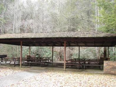
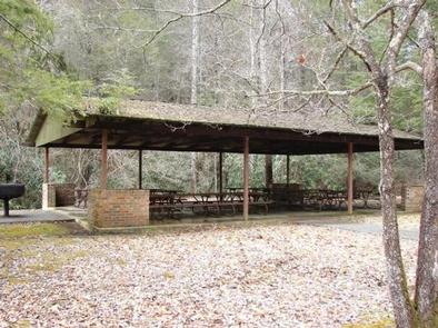
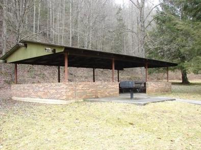
Phillips’s Creek Group Picnic area is a secluded site surrounded by forest. It is a great facility for family reunions, organization activities and other group events.

Recreation

Open lawn areas are adjacent to the picnic area can be used for activities such as horseshoes, sports and games (bring your own game and sports equipment). Hiking trails are available within easy driving distance and include Pine Mountain and Red Fox Trails. The Phillip’s Creek Trail is near the picnic area.

Facilities

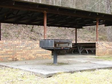
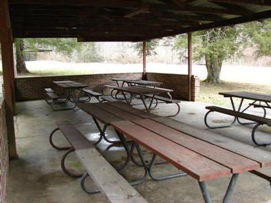
Parking is adjacent to the picnic shelters and restroom facilities. The restrooms are pit toilets. The toilets are adjacent to shelter #1 but are a short walk (850 feet) from shelter #2. A large charcoal grill is available at both shelters. Picnic tables are located inside the shelters. There is no electricity or drinking water available.

Natural Features

The picnic area is surrounded by forest. The North Fork of Pound Reservoir is nearby and is a popular boating and fishing destination.

Nearby Attractions

The Pine Mountain and Red Fox Trails are within easy driving distance.

Reservation

More from CampingHiking.net:

Tulalip Group Camp, Washington Campground Images, Info & Reservations

Listen Directions From Seattle, Washington, go north on I-5 to Everett. Take Exit 194 onto Hwy 2. At Hwy 204, go north to Lake Steven. Turn north on Hwy 9. Turn east on Hwy 92 to Granite Falls on Hwy 7 Scenic Byway. Phone 360-804-1103 Activities CAMPING Keywords TULA,MT. BAKER-SNOQU

HAWTHORN BLUFF, Oklahoma Campground Images, Info & Reservations

Listen Directions From Tulsa, Oklahoma, take U.S. Highway 169 north for 27 miles to Highway 88. The campground is 2 miles east of the town of Oologah on Highway 88. Phone 918-443-2319 Activities BOATING, CAMPING, FISHING, HIKING, VISITOR CENTER, WATER SPORTS, DAY USE AREA, SWIMMING SITE Keywords HAWT,OOLOGAH LAKE,OOLOGAH LAKE

BLOODY DICK CABIN, Montana Campground Images, Info & Reservations

Listen Directions From Dillon, travel south on I-15 for about 19 miles and exit at Clark Canyon Reservoir (Hwy 324). Travel 17 miles west on Highway 324 through Grant, MT. Proceed west and turn north onto Bloody Dick Road/Forest Road 181. Continue about 18 miles following road signs. The Bloody

TUOLUMNE MEADOWS, California Campground Images, Info & Reservations

Listen Directions Take Highway 41 north from Fresno, Highway 140 east from Merced, Highway 120 east from Manteca or west from Lee Vining (State Route 395) into Yosemite National Park. Tuolumne Meadows Campground is located 5 miles from the Tioga Pass Entrance station (Hwy 120 from the east), and is

Dub Patton Recreation Area, Mississippi Campground Images, Info & Reservations

Listen Directions From I-55 take the Coldwater, Mississippi, exit and proceed west on Scenic Route 304. Follow the signs to the camping area, which is located just north of the dam. Phone 662-562-6261 Activities BIKING, BOATING, CAMPING, FISHING, HIKING, HUNTING Keywords DUBP,ARKABUTLA LAKE,NORTH ABUTMENT,ARKABUTLA STATE PARK,ARKABUTLA LAKE Related Link(s) Rec