Directions
From Main Street in Bozeman, travel south on 19th Avenue for 7 miles to the paved Hyalite Canyon Road. Turn left and continue approximately 9 miles to the Hyalite Day Use parking area. The Pavilion is located at the far end of parking area.
Phone
406-646-1012
Activities
BOATING, FISHING, HIKING, PICNICKING, WILDLIFE VIEWING, DAY USE AREA, PHOTOGRAPHY, SWIMMING, MOUNTAIN BIKING, KAYAKING, CANOEING, STAR GAZING, BIRDING, WATER ACCESS, BACKPACKING, MUSHROOM PICKING
Keywords
Blackmore Pavilion,Blackmore Day Use,Hyalite Day use
Related Link(s)
Overview
The Hyalite Pavilion is a day use picnicking area located next to scenic Hyalite Reservoir in the Gallatin National Forest. It is 15 miles south of the city of Bozeman, MT.
Recreation
Hyalite Reservoir offers many recreational activities, including boating, canoeing and fishing. The Hyalite day use area has several picnic tables, a boat launch and ample parking. Many hiking trails are found in Hyalite Canyon, including the West Shore Trail, which can be accessed from the day use area.
Facilities
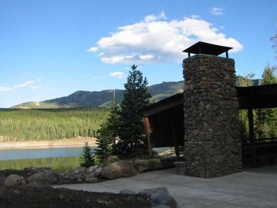
The Hyalite Pavilion is a 20 feet by 50 feet structure with existing seating for about 30 people at three non-movable tables. There is additional space within the Pavilion for users to set up their own small portable tables and chairs. A maximum capacity at the Pavilion is 80 people. Inside the Pavilion are two barbeque grills and a fireplace. Outside the Pavilion is a fire ring surrounded by sitting boulders. An accessible toilet is located approximately 250 feet away along a trail that meets accessibility guidelines (asphalt, 5% grade). Overnight use or camping is prohibited at the Pavilion; however, Hood Creek Campground is located on the opposite side of the reservoir. A hand pump for water is approximately 100 yards from the Pavilion. No garbage service is available at this facility. The Pavilion and its surrounding site were constructed through a partnership between the Gallatin National Forest, the Montana State University School of Architecture and local partners. It was designed to provide a sheltered group picnic facility that fits into its natural setting while taking advantage of the beautiful views to the surrounding hills, mountains and forest.
Natural Features
The Pavilion sets next to Hyalite Reservoir. The Reservoir, constructed in the late 1940s, contains cutthroat trout and arctic graying.
Nearby Attractions
Hood Creek Campground is approximately 1.5 miles from the Pavilion. Access to the West Shore Trail is located at the site.


