POPLAR GROVE YOUTH GROUP CAMPGROUND, MD Campground Reservation, Info, Images, Map, Directions

POPLAR GROVE YOUTH GROUP CAMPGROUND, Maryland Campground Images, Info & Reservations

Directions

Poplar Grove is located on Manahan Road in the western portion of Catoctin Mountain Park. From Route 15, exit at Catocin Mountain Park/Route 77. Travel approximately six miles west, passing the Visitor Center and Park Central Road. Turn right on Foxville-Deerfield Road and bear to the right onto Manahan Road at the fork. Poplar Grove is located about a mile ahead on the gravel road.

Phone

1 (301) 663-9388

Activities

CAMPING, HIKING, PICNICKING

Keywords

CG05,Youth Group Area,Group Camping Area,Catoctin National Park,Catoctin,Poplar,Catoctin Mountain

Related Link(s)

Rec Area Info & Images

Maryland State Tourism

Maryland State Road Conditions

Overview

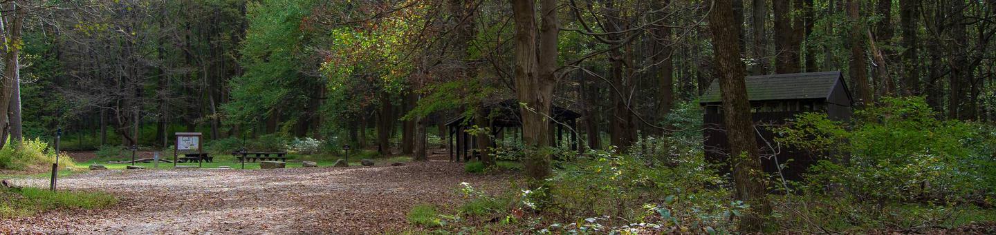
Poplar Grove offers youth groups and organizations enjoyable year-round primitive tent camping. Located just steps away from the Catoctin Mountain Park portion of the Catoctin National Recreation Trail in the rolling hills of Thurmont, Maryland. Poplar Grove allows youth groups to experience traditional wilderness camping in a beautiful, natural setting.

Recreation

As a primitive camping area, Poplar Grove encourages kids to use healthy doses of imagination while surrounded by the natural landscape. Nature hikes and campfire circles are popular activities. Catoctin Mountain Park boasts 25 miles of trails for additional hiking opportunities.

Facilities

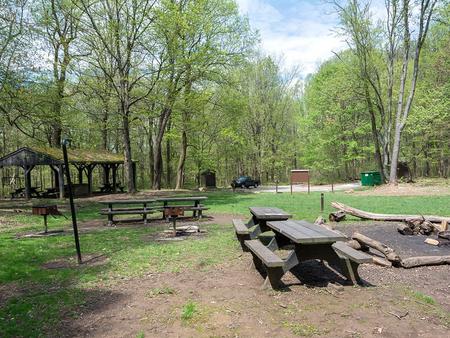
Poplar Grove allows youth to connect with nature by offering limited comforts of home. Pit toilets and drinking water are provided. Three expansive sites can accommodate up to 25 visitors each, and multiple sites may be reserved for larger groups.

Natural Features

Poplar Grove offers flat tent areas to accommodate group activities. The campground is surrounded by a rolling landscape, perfect for light hikes.

Whether blanketed in snow in winter months or blooming with wildflowers in the spring, Poplar Grove offers beautiful scenery all year. Since the site is located in a remote area, it is accessed by a gravel road during summer months, and is a hike-in only facility during winter months.

Nearby Attractions

The Catoctin Mountain Park Visitor Center is located four miles away and offers interpretive programs. Just three miles away, visitors can enjoy fishing and canoeing at Cunningham Falls State Park. Cunningham Falls charges a daily entrance fee.

Reservation

More from CampingHiking.net:

BIG CREEK CAMPGROUND, Montana Campground Images, Info & Reservations

Directions From Columbia Falls, Montana, follow State Route 486 north for approximately 20 miles to the campground entrance on the right. The road is pavement for 10 miles and gravel for approximately 9 miles. An alternate route through Glacier National Park would be to enter the park through West Glacier.

ROBIE CREEK PARK GROUP SHELTER, Idaho Campground Images, Info & Reservations

Directions From the intersection of Warm Springs Road and Highway 21, turn onto northbound Highway 21 towards Idaho City. Continue straight along Highway 21 for 9.2 miles, passing by Lucky Peak Dam and the Forest Service Nursery. Continue straight after crossing the Mores Creek "High Bridge" another 2.3 miles. Approximately

ARROW ROCK, Kansas Campground Images, Info & Reservations

Directions From US-75, take the Olivet exit. Continue onto K-276 west for 1 mile, then turn north onto South Fairlawn Road and continue another mile. Turn west onto Arrow Rock Parkway and follow to the campground. Phone 785-549-3318 Activities BOATING, CAMPING, FISHING, HUNTING Keywords ARRC,MELVERN LAKE,MELVERN PROJECT,LAKE ARROWHEAD,MELVERN STATE LAKE,MELVERN

WHITEFACE RESERVOIR, Minnesota Campground Images, Info & Reservations

Directions From Eveleth, Minnesota, take Highway 53 south for 7.8 miles, turn east on County Road 16 and travel 18.5 miles. Turn south on County Road 618 and travel 2.5 miles to Whiteface Reservoir. Phone (218)229-8800 Activities CAMPING, FISHING, HIKING, SWIMMING SITE Keywords WHIR,SUPERIOR NATIONAL FOREST,SUPERIOR NF – FS Related

AMERICAN RIDGE LODGE, Washington Campground Images, Info & Reservations

Directions Please contact the Ranger District at 509-653-1401 prior to your arrival to check any restrictions or conditions, such as fire or road closures, or weather that may affect the quality of your visit. Access to the lodge is through a locked gate. The combination to the gate lock will

LUPINE SHELTER, Montana Campground Images, Info & Reservations

Directions From Wise River, Montana, take the Pioneer Mountains Scenic Byway approximately 25 miles south. Phone 406-832-3178 Activities BIKING, CAMPING, FISHING, HIKING, WINTER SPORTS, WILDLIFE VIEWING Keywords LUPI,LUPINE,SHELTER,BEAVERHEAD-DEERLODGE NF -FS Related Link(s) Rec Area Info & Images Montana State Tourism Montana State Road Conditions Overview Lupine Shelter is a picnicking