ALPINE RANGER STATION, CO Campground Reservation, Info, Images, Map, Directions

ALPINE RANGER STATION, Colorado Campground Images, Info & Reservations

Listen

Directions

From Gunnison: Take US-50 west for approximately 35 miles. Turn left on Co. Rd 66 to FSR 867. Follow FSR 867 for approximately 20 miles to its junction with FSR 868. Turn right – Alpine Ranger Station will be 5 miles ahead on the right-hand side.

Phone

970-641-0471

Activities

CAMPING, FISHING, HIKING, HORSEBACK RIDING, HUNTING, WILDLIFE VIEWING

Keywords

Alpine Guard Station

Related Link(s)

Rec Area Info & Images

Colorado State Road Conditions

Colorado State Tourism

Overview

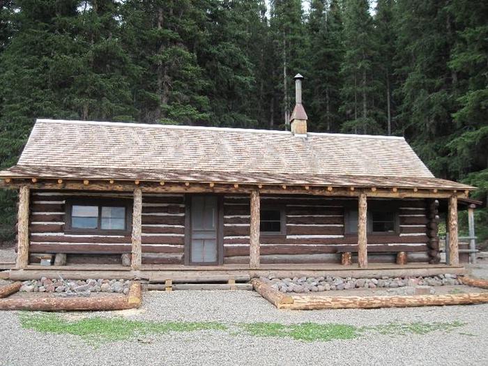
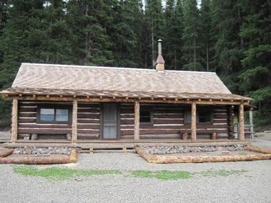
The Alpine Ranger Station is situated on the Alpine Plateau at 9,600 feet, in a beautiful alpine valley surrounded by aspen, spruce and fir forest. With inspiring views and multiple nearby recreation opportunities, the Ranger Station is just the place for a quiet and historic retreat, with a few modern amenities.

Recreation

Surrounded by miles of National Forest, visitors to the Alpine Ranger Station can enjoy a multitude of outdoor activities. There are several hiking and mountain biking trails nearby, as well as opportunities for OHV use, including ATV and motorcycle routes. Also, the ranger station has a horse barn and small corral, offering the opportunity for horseback riding. The Uncompahgre Wilderness is adjacent to the Ranger Station and a trailhead to Uncompahgre Peak (a popular 14’er) is only a mile away.

Facilities

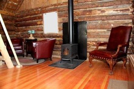
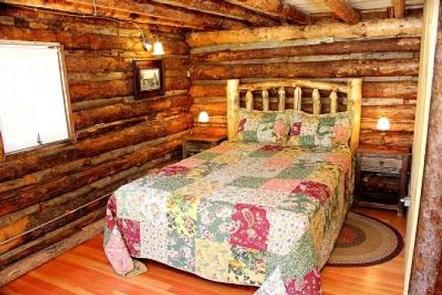
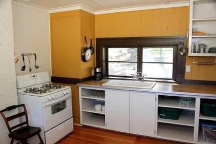
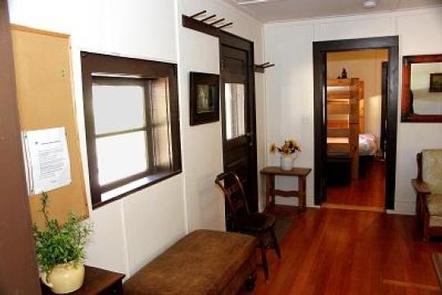
Visitors can expect to experience a semi-rustic cabin with some modern amenities. The cabin has a modernized kitchen with a propane cooking stove, refrigerator, and sink. There is an indoor bathroom with a shower and flush toilet. Other amenities include: electric lighting, a pot belly wood stove and propane heat. The cabin can accommodate up to six people comfortably – there are two bunk beds with four twin-size mattresses, and one queen bed.

Basic kitchen supplies – pots/pans/silverware – are provided. Cleaning supplies are provided, and guests are requested to clean before they leave. Guests should bring their own bedding and towels.

Plan to pack it in, pack it out. Please take your trash with you when you leave.

Natural Features

The Ranger Station is located at the end of Forest Service Road 868, past the Big Blue Campground and adjacent to Blue Creek and Soldier Creek. This beautiful area offers many scenic viewing opportunities, including the Cannibal Plateau and the Uncompahgre Wilderness.

Reservation

More from CampingHiking.net:

GROUSE VALLEY, California Campground Images, Info & Reservations

Listen Directions The county road from Springville to the cabins is narrow with many sharp turns, and vehicles over 22 feet are not advised. Take Highway 190 east from Porterville to Springville. After passing through Springville, take a left on Balch Park Road. Drive approximately 10.5 miles, then turn left

HOLLY BAY, Kentucky Campground Images, Info & Reservations

Listen Directions From London, Kentucky, take Exit 38 off I-75. Turn west on KY 192, then go 14.2 miles and turn south (left) on KY 1193. Follow signs to Holly Bay Campground entrance (3 miles). Phone 606-528-6156 Activities BIKING, BOATING, CAMPING, INTERPRETIVE PROGRAMS, FISHING, DAY USE AREA, SWIMMING SITE Keywords

JORDAN PINES, Utah Campground Images, Info & Reservations

Listen Directions From I-215, take the 6200 south exit and travel a mile east to Wasatch Blvd. Take Wasatch Blvd a mile south to junction with Big Cottonwood Canyon/Highway 190. Make a left at the junction and travel up Big Cottonwood Canyon 9.2 miles to the campground. Phone SALT LAKE

ISLET CAMPGROUND, Oregon Campground Images, Info & Reservations

Listen Directions Located 37.3 miles east of Oakridge, Oregon. From Oakridge, Oregon: At the intersection of Crestview Street and Oregon State Highway 58, travel east on Highway 58 for 23.3 miles. Turn left on the Waldo Lake Road/Forest Road 5897. Travel for 12.8 miles and turn left at the T

COWPUNCHER GUARD STATION, Utah Campground Images, Info & Reservations

Listen Directions From Highway 12 in Escalante, turn north on 300E. Drive 14 miles to the junction of Forest Roads 154 and 153. Continue on FR153 for 4.5 miles. Turn left on FR145 towards Cowpuncher and Blue Spruce Campground. Travel 0.7 miles to Cowpuncher Gate. The cabin is 0.2 miles

TAYLOR FERRY, Oklahoma Campground Images, Info & Reservations

Listen Directions Address for GPS: Taylor Ferry South Campground, 33814 E. 746 Rd., Wagoner, OK 74467 From Wagoner, Oklahoma, travel 5 miles east on Highway 51. Turn left on South 330 Road and travel south for approximatly 1/4 mile. Turn left on East 746 Road and travel less than 1