BLUE LAKE CAMPGROUND, CO Campground Reservation, Info, Images, Map, Directions

BLUE LAKE CAMPGROUND, Colorado Campground Images, Info & Reservations

Listen

Directions

From Colorado Highway 12 south of the Town of Cuchara, take FSR 422 4 miles west to the campground.

Phone

FOR RESERVATIONS CALL (877) 444-6777, FOR OTHER, NON REAL TIME INFORMATION, CALL (719) 269-8500.

Activities

BIKING, CAMPING, FISHING

Keywords

Related Link(s)

Rec Area Info & Images

Colorado State Road Conditions

Colorado State Tourism

Overview

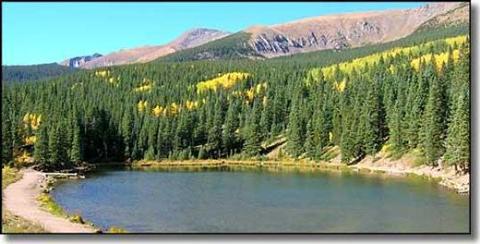
Blue Lake Campground is located in the beautiful San Isabel National Forest at an elevation of 10,500 ft. Views of the nearby Culebra Range Mountains with aspen and spruce forests offer campers a genuine Colorado experience.

Recreation

A well-marked trail system between Bear Lake and Blue Lake is open to foot and horse traffic. Across the road from the campground FSR 436, a rough jeep road, provides access to Trinchera Peak where Big Horn Sheep are often seen.
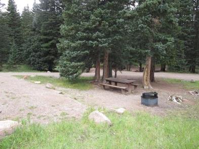
Facilities

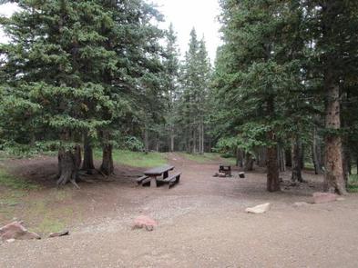
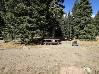
This rustic campground has 16 campsites, each with a table and fire ring. Some are shaded; others provide full sunlight. An on-site camp host offers firewood bundles for sale. Vault toilets and drinking water are available. No electric or septic hook-ups are available. Both reservation and first-come, first-served sites are available.

Natural Features

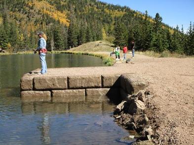
A tributary of the Cuchara River runs through the campground. Blue Lake is 1/2 mile from the campground, and Bear Lake is one mile away. Both of these small lakes are stocked several times during the summer providing for good fishing.

Nearby Attractions

The nearby mountain town of Cuchara offers shopping and visitor information. The town of La Veta offers a grocery store, gas stations, and shops. The Spanish Peaks Wilderness, 14 miles from the campground, is a popular hiking destination.

Reservation

More from CampingHiking.net:

CLEAR LAKE GROUP SITE, Washington Campground Images, Info & Reservations

Listen Directions From Naches, Washington, follow Highway 12 west for approximately 34 miles to County Road 1200/Tieton Reservoir Road at the west end of Rimrock Lake. Turn south/left on County Road 1200 and follow for about .3 miles to Road 740. Continue for a half-mile, and the reservation site is

IVES RUN, Pennsylvania Campground Images, Info & Reservations

Listen Directions The campground is located 4 miles south of Tioga and 12 miles north of Wellsboro, Pennsylvania, on State Route 287, within the Ives Run Recreation Area. Phone 570-835-5281 Activities BOATING, CAMPING, FISHING, HIKING, HUNTING, VISITOR CENTER, DAY USE AREA, SWIMMING SITE Keywords IVES,TIOGA-HAMMOND LAKES,TIOGA-HAMMOND LAKE Related Link(s) Rec

CURLEW CAMPGROUND, Idaho Campground Images, Info & Reservations

Listen Directions Take the Snowville, Utah, exit off Interstate 84, northwest of Tremonton. Continue north on the paved highway for 6.5 miles. Turn left (north) at the Curlew Campground sign, then go another half-mile on a gravel road to the campground. From Holbrook, Idaho, travel 24 miles west of Malad

HARD ROCK CAMPGROUND, Oregon Campground Images, Info & Reservations

Listen Directions From Blue River, OR, travel 4 miles east on Highway 126 to Aufderheide Drive (Forest Service Road 19). Turn right on Aufderheide Drive and continue south about 3/4 mile. Veer right at the Y and continue 10 miles to the campground. Phone 801-226-3564 Activities FISHING, WILDLIFE VIEWING Keywords

HUNTERS GROUP SITE, Washington Campground Images, Info & Reservations

Listen Directions Take State Highway 2 west of Spokane for 32 miles to the town of Davenport. Turn north on State Highway 25 and travel 37 miles. Follow signs for the campground. Turn left (west) on Campground Road in the town of Hunters. Phone 509-754-7889 Activities BOATING, HISTORIC & CULTURAL