Aitch Picnic Shelter, PA Campground Reservation, Info, Images, Map, Directions

Aitch Picnic Shelter, Pennsylvania Campground Images, Info & Reservations

Listen

Directions

Aitch is located near the town of Marklesburg, PA. From Huntingdon continue 10.5 miles southbound along Rt. 26 to Marklesburg. At Markelsburg turn left onto Aitch Road (marked by sign). Aitch Road leads directly to the Shelter location (0.8 miles).

Phone

814-658-3405

Activities

BOATING, HISTORIC & CULTURAL SITE, CAMPING, FISHING, HUNTING

Keywords

Aitch Shelter,Aitch

Related Link(s)

Rec Area Info & Images

Pennsylvania State Road Conditions

Pennsylvania State Tourism

Overview

Aitch Recreation Area is located approximately near the geographic middle of Raystown Lake along the western side. The recreation area is easily accessible from US Route 26 and offers a great location for picnicking and fishing on an accessible pier.

Recreation

Lakeside fishing piers and excellent aquatic habitat makes Aitch a popular area for shoreline anglers. A boat ramp within the facility provides access to the 8,300-acre Raystown Lake, which is popular for boating, camping and fishing.

Facilities

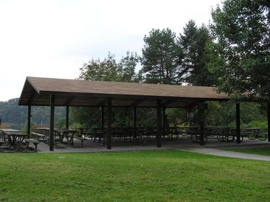
Aitch offers one group shelter with approximately 10 tables and 20-amp electrical outlets. It is fully accessible and comfortably accommodates up to 80 people with a view of the lake.

Natural Features

Aitch is situated in a cove of Raystown Lake. Nearby access to the lake makes this shelter a great place to picnic, fish and boat.

Nearby Attractions

The area offers Aitch Boat Launch, James Creek Boat Launch, Tatman Run Recreation Area, Lake Raystown Resort, Seven Points Recreation Area and the Seven Points Marina.

Reservation

More from CampingHiking.net:

LOGGER CAMPGROUND, California Campground Images, Info & Reservations

Listen Directions From Truckee, Calif., travel east on Interstate 80 for 10 miles, to the Hirschdale Road exit. Follow Hirschdale Road/Stampede Dam Road north for eight miles, to the Stampede Reservoir. Take a left on Dog Valley Road to go over Stampede Dam. Go past Emigrant Group Campground and in

LOWRY CAMPGROUND, Colorado Campground Images, Info & Reservations

Listen Directions From I-70, take exit 205. Travel east on Highway 6 towards Keystone, Colorado, for approximately 3 miles. Turn right on Swan Mountain Road and proceed 1.5 miles to the Lowry Campground sign. Turn left and proceed a half mile to the campground. Phone 970-468-7681 Activities BOATING, CAMPING, FISHING,

CHISHOLM TRAIL RIDGE, Oklahoma Campground Images, Info & Reservations

Listen Directions From Waurika, Oklahoma, take Highway 5 northwest for 5 miles. Turn right onto Advent Road and proceed 3 miles. Turn left on Chisholm Trail Road and drive one mile to the park entrance. Phone 580-439-8040 Activities BOATING, CAMPING, FISHING, SWIMMING SITE Keywords CHIS,WAURIKA LAKE,WAURIKA LAKE Related Link(s) Rec

SUTTON CAMPGROUND, Oregon Campground Images, Info & Reservations

Listen Directions From Florence, Oregon, take Highway 101 north 5 miles to the Sutton Campground turnoff and go one mile to the campground. Phone 541-997-2715 Activities BOATING, CAMPING, FISHING, HIKING, WILDLIFE VIEWING, SWIMMING SITE, BERRY PICKING Keywords SUTT,SIUSLAW NF – FS Related Link(s) Rec Area Info & Images Oregon State

EAST MEADOW CAMPGROUND, California Campground Images, Info & Reservations

Listen Directions Take Interstate 80 to the Truckee/Highway 89 North exit. Follow Highway 89 north for 17 miles, to the turnoff for Jackson Meadows. Travel west on Forest Road 07 for 18 miles to Jackson Meadows Reservoir. Turn into the campground at the Pass Creek Campground sign. Phone 530-265-8861 Activities