

Directions
From Horseshoe Bend, Idaho, take State Highway 52 for 9 miles, then turn right on Sweet/Ola Highway and travel 16 miles to Ola. From Ola, continue 10 miles northeast on FS Rd 618, then make a right on FS Rd 626 and follow it for 7 miles. Make a left on FS Rd 614 and travel about 2 miles to Sage Hen Reservoir. Antelope Campground is on the north end of the reservoir.
Phone
541-351-1182
Activities
BIKING, BOATING, CAMPING, FISHING, HIKING, HUNTING, WILDLIFE VIEWING
Keywords
ANTE,SAGEHEN RESERVOIR,BOISE NF – FS
Related Link(s)
Overview
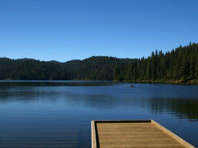
Antelope Campground is located on the shores of the scenic Sagehen Reservoir in the Boise National Forest, perched at an elevation of 5031 feet. Visitors enjoy boating, fishing and exploring the non-motorized Sagehen Reservoir Trail.
Recreation
Sagehen Reservoir offers excellent boating, canoeing and rainbow trout fishing. A boat ramp and dock are located within the campground.The speed limit on the reservoir is 15 mph.
Hiking, biking, horse and off-road vehicle trails are abundant in the area. The non-motorized Sagehen Reservoir Trail, a 4-mile loop around the lake, offers great fishing spots, beautiful viewpoints and abundant wildlife watching opportunities.
The Sagehen and KYAOTT ATV Trail Systems can be accessed near the reservoir, offering more than 35 miles of trails for off-road vehicles and motorcycles, but hikers, mountain bikers and horseback riders can enjoy these trails as well.
Facilities
The campground offers a large, tent-only group site that can accommodate up to 30 people, with several picnic tables, a grill and campfire ring. Numerous single-family sites also available, equipped with picnic tables and campfire rings.
Vault toilets and hand-pumped drinking water are provided. Roads and some parking spurs throughout the campground are paved; other spurs are gravel. Firewood is available for purchase from the host.
Natural Features
The campground is situated in a forest of towering Ponderosa pine, Engelmann spruce, Douglas fir and grand fir. Most sites have plentiful shade and some have partial lake views. Summer temperatures range from 80-90 degrees during the day with crisp, cool nights.
A variety of berries and mushrooms can be found throughout the area. Local wildlife includes deer, elk, black bear, goshawk, woodpeckers and boreal owls.