YELLOWJACKET, CA Campground Reservation, Info, Images, Map, Directions

YELLOWJACKET, California Campground Images, Info & Reservations

Listen

Directions

From Placerville, take Highway 50 east. Go 21 miles to Icehouse Road. Turn left on Icehouse Road. Then drive 14 miles north to the Yellowjacket turnoff. Drive a half mile to the campground entrance.

Phone

530-293-0827

Activities

BIKING, CAMPING, FISHING, HIKING, HUNTING, WATER SPORTS, WILDLIFE VIEWING, SWIMMING SITE, BIRDING, WATER SKIING

Keywords

YEL1,ELDORADO NF – FS,Yellow Jacket

Related Link(s)

Rec Area Info & Images

Forest Service Concessionaire

California State Road Conditions

California State Tourism

Overview

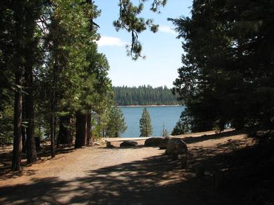
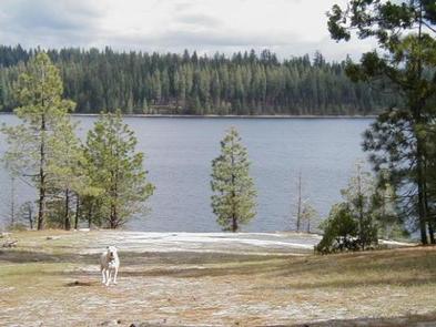
Yellowjacket Campground provides plenty of opportunities for outdoor fun on Union Valley Reservoir. The water plays host to an array of activities like water skiing and fishing. The surrounding cedar and ponderosa pine forest is a lovely setting for hiking and biking.

Recreation

The Union Valley Bike Trail spans 4.8 miles with an easy climb of 300 feet. The trail connects campgrounds on the east side of the lake, from Jones Fork Campground to Wench Creek, and is open to hikers and bikers. The Bassi Falls Hiking Trail is also worth exploring.

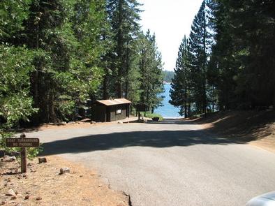
Anglers seek rainbow, brown and mackinaw trout or kokanee salmon. The reservoir also offers opportunities for swimming, water skiing and boating. A boat ramp and boat trailer parking are provided at this campground.

Facilities

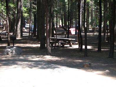
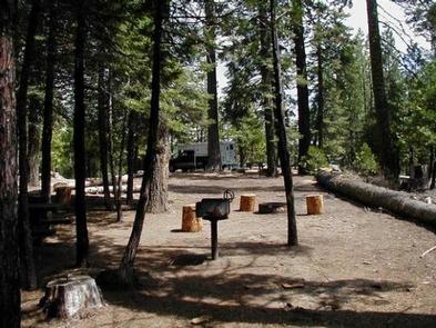
Sites are equipped with picnic tables, grills and campfire rings. The campground offers a dump station, drinking water and both flush and vault toilets.

A host is on-site. Some sites at this camp are available on a first-come, first-served basis (more campground details)

Natural Features

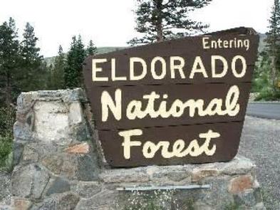
Union Valley Reservoir sits in the Crystal Basin within the Sierra Nevada Mountains at an elevation of 4,900 feet. The area is part of the Eldorado National Forest, which includes the famed gold mining territory of the 1800s. Protected remnants of the days of the California Gold Rush are all around the region.

The climate is similar to that of the Mediterranean, with warm, dry summers and cold, wet winters.

An abundance of wildlife can be found within the Sierra Nevada Range, including black bears, mule deer, bobcat, gray fox, bighorn sheep, pikas, martens and a variety of squirrels. Several species of reptiles, amphibians and birds also inhabit the area.

Nearby Attractions

The Desolation Wilderness is nearby, offering the opportunity to get away from the crowds and enjoy the serenity of nature.

Reservation

More from CampingHiking.net:

LAKEVIEW PARK, Arkansas Campground Images, Info & Reservations

Listen Directions From Mountain Home, Arkansas, take State Route 5 north for 6 miles to Midway. Turn left on State Route 178 and follow for 7 miles to Lakeview. Turn right on Boat Dock Road and follow signs into the campground. Phone 870-431-8116 Activities BOATING, CAMPING, FISHING, HIKING, WILDLIFE VIEWING,

LAKE HILL, Utah Campground Images, Info & Reservations

Listen Directions Located approximately 5 miles east of Ephraim, Utah on Forest Highway 8 in Ephraim Canyon. Phone 435-283-4151 Activities BOATING, CAMPING, FISHING, HIKING Keywords LAKH,MANTI-LASAL NF -FS Related Link(s) Rec Area Info & Images Utah State Tourism Utah State Road Conditions Overview Lake Hill Campground is situated next to

GUNTER HILL, Alabama Campground Images, Info & Reservations

Listen Directions From I-65, take exit 167 onto US-80 west. Continue for 9 miles, then turn right on County Road 7 and follow signs into the campground. Phone 334-269-1053 Activities BIKING, BOATING, CAMPING, FISHING, HUNTING Keywords GUNT,JONES BLUFF,ALABAMA RIVERS,WOODRUFF,ROBERT F. HENRY,ROBERT F HENRY,ALABAMA RIV. – WO Related Link(s) Rec Area

BISHOP MOUNTAIN CABIN, Idaho Campground Images, Info & Reservations

Listen Directions From Ashton, ID, travel north on Highway 20 for 16 miles, then turn left (west) on North Antelope Flat Road (#168). Travel 7.5 miles to Bishop Mountain Road (#120) and then turn right (north) and travel for about 5.4 miles. The road dead ends at the cabin. Phone

FOX CREEK GROUP CAMP, Oregon Campground Images, Info & Reservations

Listen Directions From Detroit, Oregon, drive east on State Highway 22. After crossing the bridge, take a left onto Forest Service Road (FSR) 46/Breitenbush. Follow FSR 46 for about 6.5 miles to Fox Creek Group Camp. Phone 503-854-3366 Activities CAMPING, FISHING, SWIMMING SITE Keywords Fox Creek,Fox Creek Group,Fox Creek Camp,FCGC,Fox

SUNNYSIDE CAMPGROUND, Oregon Campground Images, Info & Reservations

Listen Directions From Blue River, travel 4 miles east on Hwy 126 to Aufderheide Drive (FS road 19). Continue on Aufderheide Drive for 9.5 miles; turn left on FS road 1900-500 for .25 miles. Phone 801-226-3564 Activities WILDLIFE VIEWING, BIRDING Keywords SUNNYSIDE CAMPGROUND,COUGAR RESERVOIR,BLUE RIVER Related Link(s) Rec Area Info