Petaca Pinta Wilderness Study Area, New Mexico Camping & Hiking

Petaca Pinta Wilderness Study Area, New Mexico Camping & Hiking

Petaca Pinta Wilderness Study Area Image Gallery

Directions

There is currently no public access to this WSA.

Phone

505-761-8700

Activities

HIKING

Camping Reservations

Reserve your campsite at these camping areas:

New Mexico Campgrounds

Hiking Trails

Looking for nice hiking areas to take a hike? Choose from these scenic hiking trails:

New Mexico Hiking Trails

Related Link(s)

More New Mexico Recreation Areas

BLM New Mexico Twitter

BLM New Mexico YouTube Channel

BLM New Mexico Twitter

BLM New Mexico Flickr

BLM New Mexico Facebook Page

BLM New Mexico YouTube Channel

BLM New Mexico Facebook Page

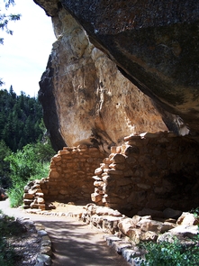
This area is known for its dramatic, colorful, and diverse topography that features lava, colorful mesas, and cliffs of sandstone. It is full of geological, biological, and archaeological features, including both riparian and canyon-wall ecology. Vegetation includes piсon-juniper, desert scrub, cottonwoods, willows, and cattails.

More from CampingHiking.net:

Atwell, California Camping & Hiking

Directions Proceed on California State Highway 99 to the community of Earlimart. Earlimart is located about 9 miles north of Delano, and 6 miles south of Pixley. Take Avenue 56,

Contra Loma Reservoir, California Camping & Hiking

Directions Site is located near Antioch, California. Phone 510-562-PARK Activities BIKING, BOATING, FISHING, HIKING, HORSEBACK RIDING, PICNICKING, RECREATIONAL VEHICLES, WATER SPORTS, PLAYGROUND PARK SPECIALIZED SPORT SITE, OTHER RECREATION CONCESSION SITE