Directions
To begin at the northern end (Alcova, Wyo.): Begin at junction of Wyoming Highway 220 and Kortes Road (Natrona County 407) and drive south. Continue on County Road 407 until the Carbon County Line where the road becomes County Road 351.
To being at the southern end (Sinclair, Wyo.): Begin at the town of Sinclair, Wyo., at the junction of Interstate 80 and Carbon County Road 351, exit 219. The byway follows County Road 351 north into Natrona County and ends at Alcova, Wyo. Please note that there are very few services and no gas available along this route.
Phone
307-328-4200
Activities
AUTO TOURING, BIKING, CLIMBING, CAMPING, FISHING, HIKING, HORSEBACK RIDING, HUNTING, WATER SPORTS, WILDLIFE VIEWING, PHOTOGRAPHY
Camping Reservations
Reserve your campsite at these camping areas:
Hiking Trails
Looking for nice hiking areas to take a hike? Choose from these scenic hiking trails:
Related Link(s)
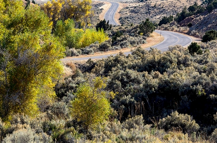
The 64-mile Seminoe-Alcova Back Country Byway lies in south central Wyoming. As you travel, you’ll pass pronghorn-grazed prairie, stark desert, and you’ll climb the rugged Seminoe Mountains. Although the road is in a remote area, the amazing transformations in the landscape are worth the back-country journey.
Attractions along the byway include Alcova and Pathfinder reservoirs, Seminoe Reservoir, the Seminoe and Pedro mountains, and Seminoe State Park. With the building of Seminoe Dam and the upgrade of the road, fishermen and boaters began visiting the area.
On your trip, you might see a variety of wildlife in the area, including mule deer, antelope, bighorn sheep, golden and bald eagles, pelicans, and ferruginous hawks. You’ll cross rugged mountains and the Miracle Mile, a blue-ribbon trout fishery of the North Platte River. There’s a huge sand dune along the way, part of the Killpecker Sand Dunes, a dune field which reaches from western Wyoming into Nebraska.

