MIDDLE FORK, WY Campground Reservation, Info, Images, Map, Directions

MIDDLE FORK, Wyoming Campground Images, Info & Reservations

Directions

From Buffalo, Wyoming, take U.S. Highway 16 west 13 miles.

Phone

406-587-9054

Activities

BIKING, CAMPING, FISHING, HIKING, HORSEBACK RIDING, WILDLIFE VIEWING

Keywords

MIDD,BIGHORN NF – FS

Related Link(s)

Rec Area Info & Images

Overview

Middle Fork Campground is located 14 miles west of Buffalo, Wyoming, adjacent to the Cloud Peak Skyway (scenic byway), near the Cloud Peak Wilderness Area. The Bighorn National Forest offers a wide variety of activities, including hiking, fishing, scenic driving and a number of historic sites. The administering organization is Gallatin Canyon Campgrounds; e-mail: gccampgrounds13@gmail.com

Recreation

Nearby Tie Hack Reservoir is a non-motorized lake offering a great location for canoeing and fishing. Anglers cast for rainbow, cutthroat, brown and brook trout.

The Circle Park Trailhead is 3.5 miles from the campground. This beautiful trail accesses numerous alpine lakes and two 12,000′ peaks within the Cloud Peak Wilderness. Many additional hiking trails are available in the area.

Scenic off-road driving is available on nearby Elgin Park, Pole Creek and Crazy Woman Canyon Roads. Hiking and mountain biking are allowed on these roads as well. Mountain bikes are allowed on the trails up to the Cloud Peak Wilderness boundary.

Facilities

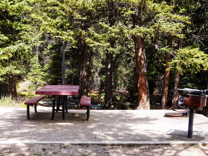
The campground offers single-family sites, each equipped with a picnic table and campfire ring with grill. Vault toilets, drinking water and trash collection are provided.

Natural Features

The campground sits on the banks of the Middle Fork of Clear Creek, within pine and aspen forests. Tie Hack Reservoir and numerous additional creeks are found nearby.

Nearby Attractions

South Fork Lodge is located within 10 miles and offers dining option, lodging, guided horseback riding, a fishing pond, and a small store with fishing and camping supplies.

A dump station is available 18 miles away at Powder River Pass.

Charges & Cancellations

Refunds: Refund requests made through www.recreation.gov will be charged a $10 processing fee. This cancellation processing fee is retained by the reservation service contractor along with the non-refundable reservation fee. All requests for the return of the non-refundable reservation fee and the cancellation processing fee will be declined by the campground concessionaire as they did not receive these fees (these are the fees retained by the reservation contractor, a different entity).

Reservation

More from CampingHiking.net:

WILBUR D. MILLS, Arkansas Campground Images, Info & Reservations

Directions From Dumas, Arkansas, travel north on US-165 for 9 miles to State Route 212. Turn right and continue 4 miles east, through Pendleton Bend Park, to the campground. Phone 870-548-2291 Activities BOATING, CAMPING, FISHING, HIKING, HUNTING, BIRDING Keywords WILB,WILBUR D. MILLS LOCK AND DAM,WILBUR MILLS PARK,MILLS PARK,WILBUR D MILLS,WILBUR

FALES FLAT CAMPGROUND, Montana Campground Images, Info & Reservations

Directions From Darby, travel south on Highway 93 for about four miles. Turn onto Highway 473 and continue southwest for 14 miles. Turn west onto Forest Road 468 and continue about 12 miles to the campground. Phone 406-821-3269 Activities BIKING, CAMPING, FISHING, HIKING, HUNTING, SCENIC DRIVE, HISTORIC SITES Keywords FFCG,Fales

LOST LAKE CABINS, Wisconsin Campground Images, Info & Reservations

Directions Lost Lake rustic cabins are located about 100 yards South of the Lost Lake Campground off of Forest Service Road 2156! From Florence, take Highway 70 for about 20 miles and take a righ onto Forest Service Road 2450, go about 1 mile and continue straight onto Forest Service

HEATON BAY, Colorado Campground Images, Info & Reservations

Directions From I-70, take Frisco exit to 203. Turn left onto the Dillon Dam Road. Travel northeast for 1 mile. The campground will be on the right hand side of the road. Phone 970-468-7681 Activities BOATING, CAMPING, FISHING, HIKING, WILDLIFE VIEWING Keywords HEA1,WHITE RIVER NF -FS Related Link(s) Rec Area

IRON SPRINGS GROUP ASHLEY, Utah Campground Images, Info & Reservations

Directions From Vernal, Utah: Travel north on U.S. Highway 191 for 20 miles. Turn northwest onto Forest Road 018/Red Cloud Loop and travel approximately 5 miles to the campground. Phone 435-789-1181 Activities BIKING, CAMPING, HIKING Keywords IROG,ASHLEY NF – FS Related Link(s) Rec Area Info & Images Utah State Tourism

OLD HIGHWAY 86, Missouri Campground Images, Info & Reservations

Directions From Branson, Missouri, take Highway 65 and turn west onto Highway 86. After 6 miles turn north on Highway UU and follow signs to the campground. Phone 417-779-5376 Activities BIKING, BOATING, CAMPING, FISHING, HIKING, PICNICKING, VISITOR CENTER, WATER SPORTS, WILDLIFE VIEWING, DAY USE AREA, SWIMMING, KAYAKING Keywords OL86,TABLE ROCK