FIREHOLE CANYON CAMPGROUND, WY Campground Reservation, Info, Images, Map, Directions

FIREHOLE CANYON CAMPGROUND, Wyoming Campground Images, Info & Reservations

Listen

Directions

From Vernal, Utah, take U.S. 191 north about 95 miles, passing through Dutch John, to Forest Road 106. Go west on Forest Road 106 for about 10 miles to the campground.

From Manila, Utah, take Highway 44 toward Highway 43. Take Highway 43 to I-80. Take I-80 east about 13.5 miles to the junction with U.S. 191. Turn south on U.S. 191 and continue 13 miles to Forest Road 106. Take Forest Road 106 west about 10 miles to the campground.

From Rock Springs, Wyoming, take I-80 west toward Green River about 6 miles to the junction with U.S. 191/Flaming Gorge Road. Take U.S. 191 13 miles south. From U.S. 191, go west on Forest Road 106 about 10 miles to the campground.

Phone

801-226-3564

Activities

BOATING, CAMPING, FISHING, SWIMMING SITE

Keywords

FIRC,FLAMING GORGE,ASHLEY NF – FS,”Flaming Gorge National Recreation Area”

Related Link(s)

Rec Area Info & Images

Forest Service Concessionaire

Overview

Firehole Canyon Campground is located on the far northeastern shore of Flaming Gorge Reservoir within the Flaming Gorge Recreation Area on the Ashley National Forest. Rock Springs, Wyoming, is just 29 miles away. Boating, fishing and water skiing are popular activities.

Recreation

Fishing, boating, canoeing, water skiing and swimming are popular activities on the lake. Campers are offered the convenience of an adjacent boat ramp and a beach area.

Facilities

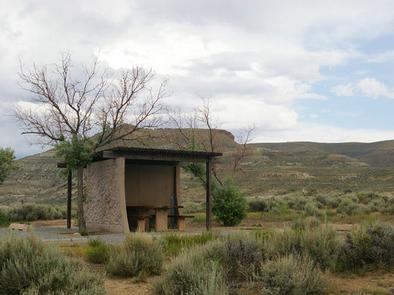
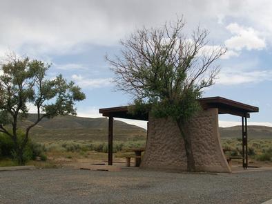
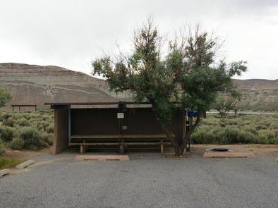
The campground contains several family campsites. Each campsite has a cabana, picnic table and campfire ring. Flush toilets, showers, drinking water and trash collection are provided. Roads and parking spurs are paved. A dump station is located on-site.

Natural Features

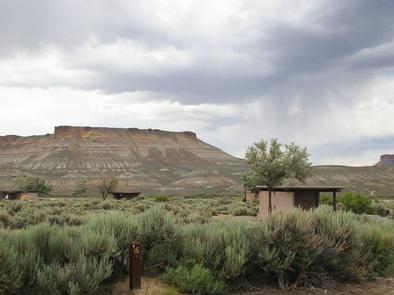
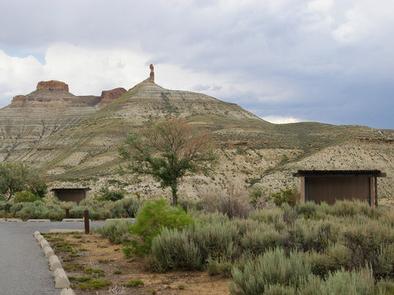
The campground lies in a high desert environment at an elevation of 6,300 feet. Russian olive trees and sagebrush are scattered throughout the site. Shade is minimal. The site affords scenic views of the reservoir and surrounding bluffs and red rock formations.

Nearby Attractions

Flaming Gorge Dam offers guided tours of the working hydroelectric plant and the dam, and the adjacent visitor center contains area history exhibits.

Reservation

More from CampingHiking.net:

GLEASONS LANDING, Michigan Campground Images, Info & Reservations

Listen Directions From Baldwin, take 7th street west 5 blocks to Cherry Street, then south 1.5 blocks to 52nd Street (Carr Road), go west 2 miles to Jenks Road and turn left. Drive 0.4 miles and turn right on Shortcut Road and drive 0.7 miles. Turn right at T junction

LOST BRIDGE SOUTH, Arkansas Campground Images, Info & Reservations

Listen Directions From Rogers, AR, take Highway 62 east for about 13 miles to Garfield. Turn right onto Highway 127 and continue for 6 miles. Turn right onto Highway 127 Spur and follow the signs into the park. Phone 479-359-3755 Activities BOATING, CAMPING, HIKING Keywords LOSS,BEAVER LAKE,LOST BRIDGE SOUTH,SOUTH SIDE,BEAVER

REDFISH CABIN, Idaho Campground Images, Info & Reservations

Listen Directions Renters should check winter road reports online at 511.idaho.gov or by calling 511 or 1-888-432-7623 prior to travel. October 15, November 30: From Stanley: Intersection of Hwy 21 and Hwy 75, drive south on Hwy 75 4.25 miles to Redfish Lake Road (FS Road 214). The turn is

BULL RIVER PAVILION, Montana Campground Images, Info & Reservations

Listen Directions From Noxon, travel 6 miles northwest on Highway 200. Bull River Pavilion is located at the back of Bull River Campground. Phone 406-827-3533 Activities BOATING, CAMPING, FISHING, WATER SPORTS, WILDLIFE VIEWING Keywords BRPA,KOOTENAI NF – FS Related Link(s) Rec Area Info & Images Montana State Tourism Montana State

BRIDGES CAMPGROUND, Utah Campground Images, Info & Reservations

Listen Directions From Huntington, Utah, travel north on Utah Highway 31 for 23 miles, to the campground. It is on the west side of Highway 31, at the mouth of Day Canyon. Phone (435)384-2372 Activities BIKING, CLIMBING, CAMPING, FISHING, HIKING, HUNTING, WILDLIFE VIEWING Keywords BRID,BRIDGES CAMPGROUND,DAY CANYON CAMPGROUND,MANTI-LASAL NF -FS

RIVERSIDE CAMPGROUND, Oregon Campground Images, Info & Reservations

Listen Directions From Sisters, OR: Travel 9.6 miles northwest on Highway 20, then 4.4 miles north on Forest Road 14. Phone 541-323-1746 Activities CAMPING Keywords Related Link(s) Rec Area Info & Images Oregon State Tourism Oregon State Road Conditions Overview Located on the upper Metolius River, Riverside Campground is one