FREMONT LAKE, WY Campground Reservation, Info, Images, Map, Directions

FREMONT LAKE, Wyoming Campground Images, Info & Reservations

Directions

From U.S. 191/Pine Street in Pinedale, Wyoming, turn northeast onto Fremont Lake Road. Drive about 4 miles to a "T" junction and turn left. Go 0.2 miles, turn right at the "Y" junction and drive 3.5 miles to the campground.

Phone

307-367-4326

Activities

BIKING, BOATING, CAMPING, FISHING, HIKING, WATER SPORTS, WILDLIFE VIEWING, SWIMMING SITE

Keywords

FREL,BRIDGER-TETON NF – FS

Related Link(s)

Rec Area Info & Images

Overview

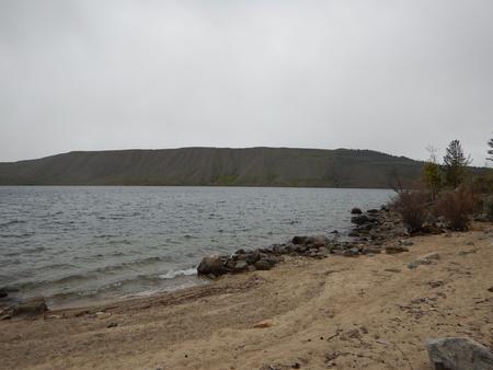
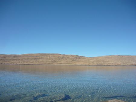
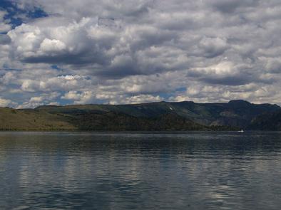
Fremont Lake Campground is located on the east shore of pristine Fremont Lake at an elevation of 7,400 feet, just 7 miles northeast of Pinedale, Wyoming, the nearest full-service community. Water sports and fishing are popular activities on the scenic lake.

Recreation

The lake provides many recreational activities. Anglers enjoy fishing for lake, rainbow and brown trout, as well as kokanee salmon. Visitors also enjoy boating, sailing, canoeing, kayaking and swimming.

Facilities

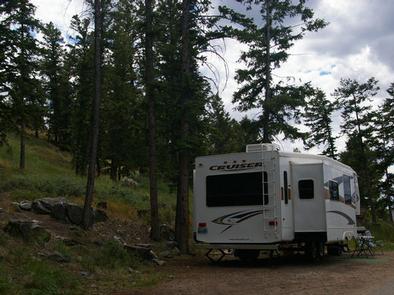
This campground offers 44 single sites, 4 double sites, and 1 group site that accomodates up to 50 people. During the peak season, two Campground Hosts are available for information and assistance. Picnic tables and fire rings with grills are provided, as are vault toilets and drinking water. A boat ramp and dock are on-site.

Natural Features

Fremont Lake sits at the foot of the rugged Wind River Range, known for its craggy granite peaks and sparkling glacial lakes. The campground is situated on a forested hillside above the lake. Aspen, Douglas fir, juniper and a dense understory provide shade and privacy between campsites.

Nearby Attractions

The Museum of the Mountain Man in Pinedale features a large collection of Rocky Mountain fur trade era artifacts. Exhibits include American Indian and Mountain Man displays, as well as history of the settlement of Sublette County, Wyoming.

Reservation

More from CampingHiking.net:

CLEAR CREEK GUARD STATION, Idaho Campground Images, Info & Reservations

Directions From Montpelier, take Highway 89 east for 7 miles. At the Montpelier Reservoir (Crow Creek Road)/ Forest Road 111, turn north and travel 13 miles to the guard station. Maps are available upon request at the district office. From Afton, Wyoming, take Highway 89 south and turn right on

WATSADLER, Georgia Campground Images, Info & Reservations

Directions Watsadler Campground Address: 286 Watsadler Road, Hartwell, Ga 30643. From I-85 North in Georgia, take exit 177 onto Highway 77 towards Hartwell, Georgia. In Hartwell, take Hwy 29 North towards Anderson, South Carolina. Continue approximately 4 miles, take a Left onto Watsadler Road; entrance will be a short distance

SOUTH KAWISHIWI RIVER, Minnesota Campground Images, Info & Reservations

Directions From Ely, Minnesota, travel about 10.3 miles south on State Highway 1 toward Lake Superior. Turn left onto the campground road. Phone KAWISHIWI RANGER DISTRICT: 218-365-7600, CONCESSIONAIRE (SUMMER): 218-365-2963 Activities BIKING, BOATING, CAMPING, FISHING, HIKING, HUNTING, WILDLIFE VIEWING, SWIMMING SITE Keywords SOKR,SUPERIOR NATIONAL FOREST,KAWISHIWI FOREST SERVICE CAMP,KAWISHIWI RIVER,KAWISHIWI,KAWISHIWI BEACH,SUPERIOR

MOUNT PRINCETON, Colorado Campground Images, Info & Reservations

Directions From Buena Vista, Colorado, take Highway 285 south to Nathrop. Turn west on County Road 162 and travel 7 miles to the campground. Phone CAMPGROUNDS DO NOT HAVE PHONE SERVICE, CALLING TO CHECK AVAILABILITY PRIOR TO ARRIVAL IS NOT POSSIBLE. FOR RESERVATIONS CALL: 1-877-444-6777 Activities HISTORIC & CULTURAL SITE,

MAMMOTH CABIN, Utah Campground Images, Info & Reservations

Directions From Fairview, Utah, for 8.5 miles proceed east on Utah Highway 31. Then turn east (left) to Utah highway 264 for .2 miles, then turn left (north) through the paved parking lot to the gravel road, then right (FS road 0124 downhill). You will pass the Gooseberry Campground sign,

PICKENSVILLE CG (PICKENSVILLE AL), Alabama Campground Images, Info & Reservations

Directions From Tuscaloosa, Alabama, take Highway 82 west to the junction with Highway 86. Turn left on 86 west to Pickensville. The entrance road to the campground is 2.5 miles from the yellow caution light. Phone 205-373-6328 Activities BIKING, CAMPING, INTERPRETIVE PROGRAMS, FISHING, HIKING, HUNTING, WILDLIFE VIEWING Keywords PICK,TENNESSEE- TOMBIGBEE