STUART RECREATION AREA, WV Campground Reservation, Info, Images, Map, Directions

STUART RECREATION AREA, West Virginia Campground Images, Info & Reservations

Directions

From Elkins, West Virginia: Take Highway 219 to Highway 33. Travel east for approximately 4 miles, turn north on old Route 33 and travel for 2 miles. Turn left at Highway 6 (at the Stuart Recreation Area directional sign) and drive .25 miles to entrance.

Phone

304-636-5070

Activities

CAMPING, FISHING, HIKING, HUNTING, SWIMMING SITE

Keywords

STUA,STEWART PARK,STEWARTS PARK,STUART PARK,STUARTS PARK,MONONGAHELA NF -FS

Related Link(s)

Rec Area Info & Images

Forest Service Concessionaire

West Virginia State Road Conditions

West Virginia State Tourism

Overview

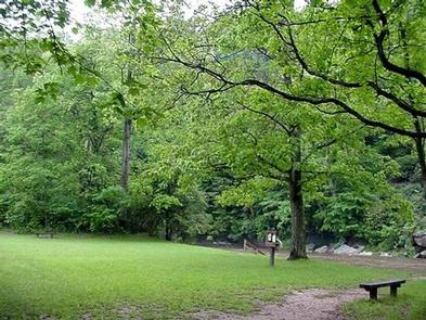
Stuart Recreation Area is set in a mixed forest along the banks of the Shavers Fork River. The river provides excellent fishing and is regularly stocked with trout. Hiking trails lead to outstanding overlooks, local caves and Blackwater Falls.

Recreation

River swimming is a lot of fun, and there are plenty of trout to tempt anglers of all skill levels. The 2-mile River Loop Hiking Trail is enjoyed by many visitors, and is a great way to watch for birds and wildlife.

Facilities

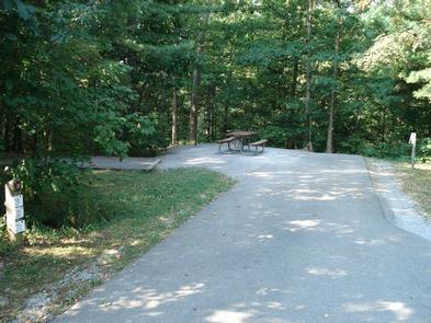
The campground lies on a single loop with long spurs. Drinking water and accessible flush toilets and showers are provided, with a dump station is on-site. Each site comes with a campfire ring, tent pad, lantern post and electric hookups.

The day-use area has three picnic pavilions with maintained fields and a beach on the riverfront.

Natural Features

The campground is perched along a bend on the Shavers Fork River. Shavers is a tributary of the Cheat River, a popular rafting river with rocky rapids.

Stuart is in the Allegheny Mountains of West Virginia. The Monongahela Forest extends over the north central highlands of the state, straddling many of the region’s highest peaks. Elevations here range from 1,000 to 4,863 feet above sea level.

Nearby Attractions

The town of Elkins is a 14-minute drive from the campground. An annual Mountain State Forest Festival takes place here every October.

Reservation

More from CampingHiking.net:

FRYING PAN, Utah Campground Images, Info & Reservations

Directions From Highway 24 northwest of Loa, Utah, take Highway 25 northeast approximately 15 miles to the campground. Phone 435-836-2811 Activities BIKING, BOATING, CAMPING, FISHING, HIKING, WILDLIFE VIEWING Keywords FRYI,FISHLAKE NF – FS Related Link(s) Rec Area Info & Images Utah State Road Conditions Utah State Tourism Overview Frying Pan

SARGE CREEK, Oklahoma Campground Images, Info & Reservations

Directions From Kaw City, Oklahoma, travel nearly 3 miles east on Highway 11, then follow signs to the campground. Phone 580-762-5611 Activities BOATING, CAMPING, FISHING, HIKING, WILDLIFE VIEWING, DAY USE AREA Keywords SARG,KAW LAKE,KAW LAKE Related Link(s) Rec Area Info & Images Oklahoma State Tourism Oklahoma State Road Conditions Overview

SLY GUARD CABIN, California Campground Images, Info & Reservations

Directions Sly Guard Cabin is located off U.S. Highway 50 in Pollock Pines, approximately 16 miles east of Placerville. Take Exit 60 (Sly Park Road) and travel south approximately 6.2 miles. Arrive at 5561 Sly Park Road on the left. Phone 530-644-2324 Activities BOATING, HISTORIC & CULTURAL SITE, CAMPING, HIKING,

HAWKER POINT, Missouri Campground Images, Info & Reservations

Directions From Stockton, Missouri, take State Highway 39 south for 6.2 miles, turn left on Highway H and continue for 5.2 miles to the park entrance. Phone 417-276-7266 Activities BOATING, CAMPING, FISHING, VISITOR CENTER, WILDLIFE VIEWING Keywords HAWK,STOCKTON LAKE,STOCKTON LAKE Related Link(s) Rec Area Info & Images Missouri State Tourism

FISHTRAP LAKE SHELTERS, Kentucky Campground Images, Info & Reservations

Directions From US-460/Shelbiana Road, continue approximately five miles, then make a slight right onto Kentucky Route 1789/Fishtrap Road. Continue three miles to the Fishtrap Lake Dam Site Recreation Area. Shelter # 1 is the first right turn after entering the dam site, located approximately one mile below the dam. Located

INDIAN FORD CAMPGROUND, Oregon Campground Images, Info & Reservations

Directions From Sisters, OR: Travel 5.6 miles northwest on Highway 20. Phone 541-323-1746 Activities CAMPING Keywords Related Link(s) Rec Area Info & Images Oregon State Road Conditions Oregon State Tourism Overview Indian Ford Campground is named for its location on Indian Ford Creek and is conveniently located between the town