BLUE BEND REC AREA, WV Campground Reservation, Info, Images, Map, Directions

BLUE BEND REC AREA, West Virginia Campground Images, Info & Reservations

Directions

From White Sulphur Springs, travel 8 miles north on State Route 92. Turn left (west) at Alvon, West Virginia, onto State Route 16. Travel 4 miles to the recreation area.

Phone

304-536-2144 FOR DISTRICT OFFICE AND 304-536-1440 FOR CAMPGROUND FROM MAY TO AUGUST

Activities

CAMPING, FISHING, HIKING, WILDLIFE VIEWING, SWIMMING SITE

Keywords

BLUE,MONONGAHELA NF -FS

Related Link(s)

Rec Area Info & Images

West Virginia State Tourism

West Virginia State Road Conditions

Overview

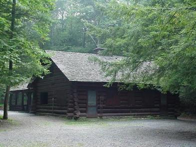
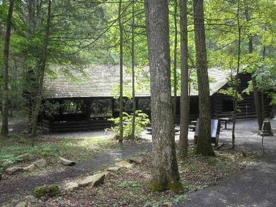
Blue Bend Recreation Area is a quaint wooded area filled with plenty of hiking, picnicking and camping opportunities. Constructed in the 1930s by the Civilian Conservation Corps, the rustic wood tables and shelters appeal to many day and overnight visitors.

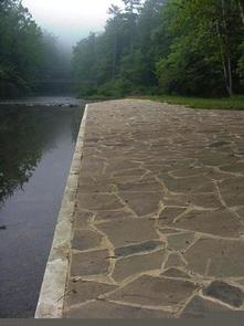
The recreation area, along Anthony Creek, has a selection of single family campsites and 2 picnic shelters. The large group picnic shelter accommodates 75 people and can be reserved in peak season.

Recreation

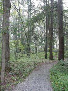
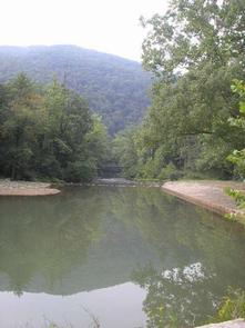
Swimming is nice and refreshing in Anthony Creek, and anglers can find trout here. The Blue Bend Recreation Area provides access to the BIg Draft WIlderness.  A popular excursion into the wilderness is the 5-mile Blue Bend Loop Trail, which connects to the Anthony Creek Trail. Blue Bend Loop Trail offers 3 scenic overlooks.

Facilities

Flush toilets and showers are available in summer, and vault toilets can be used through the spring and fall seasons. Running water is also seasonal, but a hand pump is available through spring and fall.

Each site is on a parking spur with a picnic table, campfire ring, trash bin and lantern post.

Natural Features

At an elevation of 1,860 feet, the campground is in a pleasant, wooded valley facing Round Mountain in the Monongahela National Forest. The forest comprises about a million acres of forest that attracts 1.3 million visitors each year.

A variety of animals make their home here, including black bear, coyote, wild turkey, white-tailed deer, red and gray fox, bobcat, fisher, otter and mink.

Nearby Attractions

Reservation

More from CampingHiking.net:

CRANE FLAT, California Campground Images, Info & Reservations

Directions Take Highway 41 north from Fresno, Highway 140 east from Merced, or Highway 120 east from Manteca into Yosemite National Park. Crane Flat Campground is located 8 miles from the Big Oak Flat Entrance Station (Hwy 120 from the west), and is 17 miles (30 minutes) northwest of Yosemite

SUNLIGHT RANGERS CABIN, Wyoming Campground Images, Info & Reservations

Directions From Cody, drive approximately 16 miles north on Highway 120, then take Chief Joseph Scenic Highway/Highway 296 west for 22 miles, up and over Dead Indian Pass and on to Sunlight. Sunlight Road/Forest Road 101 will be on your left just before you reach the Sunlight Bridge Overlook. Drive

DIABLO, California Campground Images, Info & Reservations

Directions From Sierraville, travel south on Highway 49 for 18 miles. Turn right at Bassett and continue just over a mile to the Sardine Lake turnoff. Turn right at Packer Lake/Forest Road 93 and continue to the campground. Phone (530)478-6253 Activities BIKING, BOATING, CAMPING, FISHING, HIKING, HUNTING, WILDLIFE VIEWING Keywords

LITTLE BROOKLYN LAKE GUARD, Wyoming Campground Images, Info & Reservations

Directions From Laramie, Wyoming, take Hwy 130 to Centennial, Wyoming. Travel approximately 9 miles west of Centennial on Highway 130 to Brooklyn Lake Road (Forest Service Road 317) located on the north (right) side of the highway. The Guard Station is on Brooklyn Lake Road approximately 1 mile from the

POOLE CREEK, Oregon Campground Images, Info & Reservations

Directions From Roseburg, OR, travel east on OR-138 / NE Diamond Lake Boulevard for approximately 72 miles, turn left onto Forest Road 2610 (Bird’s Point Road). Proceed 4 miles and turn right at the Poole Creek Campground sign. The campground is located on the west shore of Lemolo Lake. Turn

STRAWBERRY BAY, Utah Campground Images, Info & Reservations

Directions From Heber City, Utah, take Highway 40 east for 28 miles to Strawberry Bay Junction. Follow the signs for 6 miles to the campground. Phone HEBER RANGER DISTRICT 435-783-4338 OR UTAH RECREATION COMPANY 385-273-1100 Activities BOATING, CAMPING, FISHING, VISITOR CENTER, DAY USE AREA, WATER ACTIVITIES Keywords STRA,UINTA NF –