SHORELINE, ID Campground Reservation, Info, Images, Map, Directions

SHORELINE, Idaho Campground Images, Info & Reservations

Directions

From Boise, Idaho, travel 85 miles north on Highway 55 to Cascade. Turn east on Warm Lake Highway and go 25 miles to Forest Road 489. Turn south and continue a half-mile to the campground.

Phone

208-382-7400

Activities

BIKING, BOATING, CAMPING, FISHING, HIKING, HUNTING, WILDLIFE VIEWING, SWIMMING SITE

Keywords

SHOR,FS CASCADE RANGER DISTRICT,CASCADE WARM LAKE SHORELINE CG,SHORELINE GROUP SITE,BOISE NF – FS

Related Link(s)

Rec Area Info & Images

Idaho State Tourism

Idaho State Road Conditions

Overview

Shoreline Campground is located just across the road from beautiful Warm Lake, at an elevation of 5,300 feet. Visitors enjoy boating, fishing, swimming, hiking and viewing local wildlife.

Recreation

Warm Lake offers great fishing opportunities for cutthroat, rainbow, lake and bull trout. Boating, canoeing and swimming are popular activities. Billy Rice Swim Beach is nearby, offering a day-use site for picnicking and swimming. A boat ramp is located just across the road from the campground.

The surrounding area offers great hiking, mountain biking, horseback and off-road vehicle riding, and hunting. The WeWuKiye (Wa Wu Kia) Trail No. 252 is popular among hikers and mountain bikers. It was recently built and can be accessed at the campground’s entrance.

For off-road vehicle enthusiasts, Telephone Ridge Trail No. 112 offers 20 miles of trails for all riding levels, with staging areas within the campground and at Warm Lake Campground just down the road.

Facilities

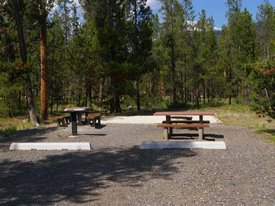
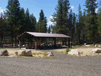
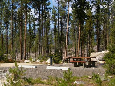
The campground contains several single and double campsites, most of which are accessible. An accessible group site with picnic shelter is also available and can accommodate up to 50 people. A volleyball court and horseshoe pits are located next to the group site.

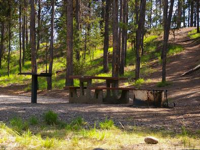
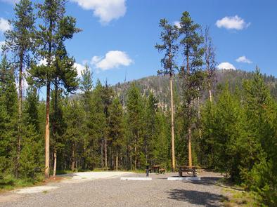
Picnic tables, campfire rings and grills are available at the campsites. Vault toilets and drinking water are also provided. There is no electricity at the campground.

Natural Features

The campground is situated in a mixed-growth lodgepole pine forest, which offers partial shade. Summer wildflowers are abundant in the area. A variety of wildlife including bears, deer, elk, fox, grouse, eagles, osprey, grosbeaks, whooping cranes and otters, lives around the lake.

Reservation

More from CampingHiking.net:

RADEKE CABIN, New Hampshire Campground Images, Info & Reservations

Directions From NH Route 16 in Conway, take NH route 112 (Kancamagus Highway) west for 14 miles. The cabin is on the right, a quarter mile before Passaconaway Campground. From Interstate route 93 in Lincoln, take exit 32 for NH Route 112. At bottom of exit ramp, turn left (east)

La Wis Wis Campground, Washington Campground Images, Info & Reservations

Directions From Packwood, Washington, go 5 miles east on State Route 12 to Campground. Phone 541-338-7869 Activities BIKING, CAMPING, INTERPRETIVE PROGRAMS, FISHING, HIKING, WILDLIFE VIEWING, DAY USE AREA Keywords LAWI,WHITE PASS,PACKWOOD,MT RANIER,GIFFORD PINCHOT NF – FS,COHO Related Link(s) Rec Area Info & Images Washington State Tourism Forest Service Concessionaire Washington

QUARRY COVE, Arkansas Campground Images, Info & Reservations

Directions From Ola, Arkansas, take Route 7 south for 9 miles. Turn west onto US-60, and continue for .5 miles and follow signs into campground. Phone 479-272-4233 Activities BOATING, CAMPING, FISHING, SWIMMING SITE Keywords QUAR,NIMROD LAKE,NIMROD LAKE Related Link(s) Rec Area Info & Images Arkansas State Road Conditions Arkansas State

FREMONT LAKE, Wyoming Campground Images, Info & Reservations

Directions From U.S. 191/Pine Street in Pinedale, Wyoming, turn northeast onto Fremont Lake Road. Drive about 4 miles to a "T" junction and turn left. Go 0.2 miles, turn right at the "Y" junction and drive 3.5 miles to the campground. Phone 307-367-4326 Activities BIKING, BOATING, CAMPING, FISHING, HIKING, WATER

RIVERSIDE EAST, Kansas Campground Images, Info & Reservations

Directions From Burlington, Kansas, take US 75 north for about 3.5 miles, then turn west onto Embankment Road and continue for 1.5 miles and follow signs to park entrance. Phone 620-364-8613 Activities BIKING, CAMPING, FISHING, HIKING, HUNTING Keywords RIEA,JOHN REDMOND RESERVOIR,JOHN REDMOND RESERVOIR Related Link(s) Rec Area Info & Images

DEEP CREEK PICNIC PAVILION, North Carolina Campground Images, Info & Reservations

Directions Seasonal phone is 828-488-3184 From downtown Bryson City, NC: Follow signs to Deep Creek, 3 miles away. Phone 865-436-1261 Activities HISTORIC & CULTURAL SITE, CAMPING, FISHING, HIKING, HORSEBACK RIDING, VISITOR CENTER, WILDLIFE VIEWING Keywords Great Smoky Mountains National Park,Great Smokey Mountains National Park,Great Smoky Mountain National Park Related Link(s)