TRUMBULL LAKE, CA Campground Reservation, Info, Images, Map, Directions

TRUMBULL LAKE, California Campground Images, Info & Reservations

Directions

Travel 13.5 miles south of Bridgeport on Highway 395. Turn right at Conway Summit. Travel 5.9 miles on Forest Road 21 to where the asphalt turns to gravel. Turn right at campground entrance.

Phone

760-932-7092

Activities

BOATING, CAMPING, FISHING

Keywords

TRUM,HUMBOLDT-TOIYABE NF-FS,TRUMBALL LAKE

Related Link(s)

Rec Area Info & Images

California State Tourism

California State Road Conditions

Forest Service Concessionaire

Overview

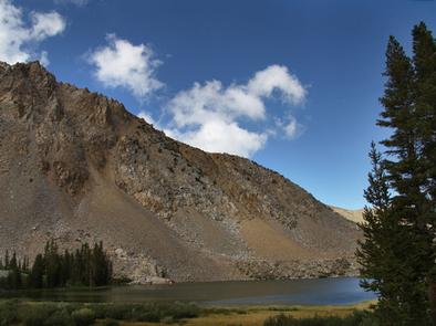
Trumbull Lake Campground is located next to its scenic namesake at an elevation of 9,980 feet. The lake is one of ten alpine lakes in the area. Visitors enjoy fishing, canoeing and exploring local trails.

Recreation

Trumbull Lake offers canoeing and fishing for rainbow, brown and brook trout in a beautiful natural setting.

Facilities

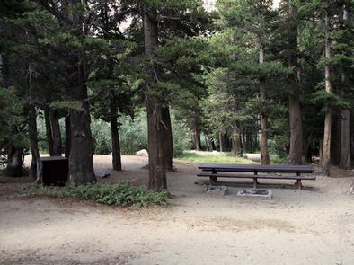
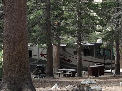
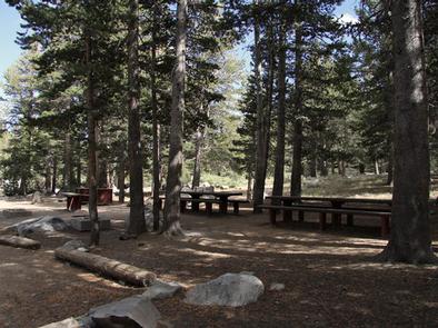
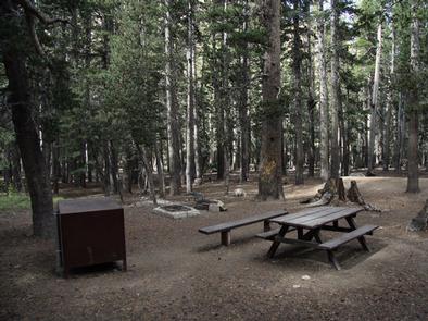
This campground contains several single-family sites, a few double sites and one triple site, all with picnic tables, food storage lockers and campfire rings with grills. A few sites closer to the water have partial lake views. picnic tables, food storage lockers and campfire rings with grills. A few sites closer to the water have partial lake views.

Vault toilets, drinking water and trash collection are provided. Firewood is available for purchase from the host. Roads and parking spurs are dirt.

Natural Features

The campground is situated on the shores of quiet Trumbull Lake, a 100-acre lake surrounded by towering peaks and glacier-carved cirques. A dense forest of lodgepole pine covers the campground, providing ample shade in most campsites. Aspens and summer wildflowers dot the landscape.

Nearby Attractions

The Virginia Lakes area is very close, offering additional canoeing and fishing. The Virginia Lake Trail, for hiking and horseback riding, provides access into the adjacent Hoover Wilderness Area and Yosemite National Park. Bodie State Park.

Reservation

More from CampingHiking.net:

Goose Island Group Sites, Utah Campground Images, Info & Reservations

Directions From Moab, drive north on Highway 191 to the junction of State Route 128. Drive two miles on SR 128 to the entrance to Goose Island campground. The group sites are at the far end of the campground. Phone 435-259-2100 Activities AUTO TOURING, BIKING, CAMPING, PHOTOGRAPHY, MOUNTAIN BIKING, SCENIC

HUNTER PEAK, Wyoming Campground Images, Info & Reservations

Directions From Cody, Wyo., travel north on State Highway 120 to Highway 296. The campground is approximately 60 miles from Cody, and located on the left side of the highway. From the northeast entrance of Yellowstone Park or Red Lodge, Mont, travel on U.S. Highway 212 to the junction with

LITTLE BROOKLYN LAKE GUARD, Wyoming Campground Images, Info & Reservations

Directions From Laramie, Wyoming, take Hwy 130 to Centennial, Wyoming. Travel approximately 9 miles west of Centennial on Highway 130 to Brooklyn Lake Road (Forest Service Road 317) located on the north (right) side of the highway. The Guard Station is on Brooklyn Lake Road approximately 1 mile from the

LOUELLA CABIN, Washington Campground Images, Info & Reservations

Directions From Sequim east, for approximately 3 miles. Just past John Wayne Marina Road, turn right onto the Palo Alto Road and travel approximately 8 miles. The access drive to Louella Cabin is by an information kiosk on the right. Turn into the driveway, go past the first building, and

LAKESIDE (OK), Oklahoma Campground Images, Info & Reservations

Directions From Durant, Oklahoma, travel 10 miles west on HWY 70 to Streetman Road. Turn south on Streetman Road and follow it 4 miles to the park entrance. Physical address: 3991 Streetman Road, Mead, OK 73449 Phone 580-920-0176 Activities CAMPING Keywords LASD,TEXOMA LAKE,TEXOMA LAKE Related Link(s) Rec Area Info &