BIG LAKE, OR Campground Reservation, Info, Images, Map, Directions

BIG LAKE, Oregon Campground Images, Info & Reservations

Directions

From Eugene, Oregon, take I-105 east to McKenzie Highway 126. Travel east on 126 for 90 miles to Santiam Pass. At the top of the Pass, turn right onto the access road (sign says Hoodoo Ski Area, Big Lake Road, & Benson Sno-Park). Travel one mile to the fork in the road and stay left on Forest Service Road 2690. Continue for 2 miles to the entrance to Big Lake Campground on the left.

Phone

801-226-3564

Activities

BIKING, BOATING, HIKING, OFF HIGHWAY VEHICLE, SWIMMING, NON-MOTORIZED BOATING, WATER SKIING

Keywords

BIOR,WILLAMETTE NF -FS

Related Link(s)

Rec Area Info & Images

Oregon State Road Conditions

Forest Service Concessionaire

Oregon State Tourism

Overview

Big Lake Campground sits at its namesake lake along Santiam Pass, a 4,800-foot mountain pass through the Cascade Range in western Oregon.

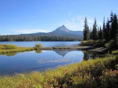
Campers enjoy views of the lake with the beautiful Mt. Washington as a backdrop.

Recreation

Water skiing, sailing and swimming are among the favorite activities at the lake. The Patjens Lakes Trail offers excellent hiking opportunities. The trail follows the western side of Big Lake, heads south into the Mt. Washington Wilderness, passes alongside the scenic Patjens Lakes, and then loops back to the campground.

Facilities

Big Lake Campground offers 49 spacious campsites for tent or RV camping. Drinking water, vault toilets and a boat ramp are provided.

Natural Features

Surrounded by Alpine fir, hemlock and lodge pole pine, the campground sits on the western side of the lake.

Big Lake, at elevation 4,600 feet, is in the Willamette National Forest, which spans 1.6 million acres on the western slopes of the Cascade Mountains.

Nearby Attractions

Several hiking trails and OHV trails are in the area. Explore the Santiam Pass region on the McKenzie Pass – Santiam Pass National Scenic Byway that passes through 130 miles of lava fields, lakes and waterfalls.

Reservation

More from CampingHiking.net:

GENTRY CREEK, Oklahoma Campground Images, Info & Reservations

Directions From Checotah, Oklahoma, travel 9 miles west on Highway 266. Follow the signs to the campground entrance. Phone 918-799-5843 Activities BOATING, CAMPING, FISHING, HIKING Keywords GENT,EUFAULA LAKE,EUFAULA LAKE Related Link(s) Rec Area Info & Images Oklahoma State Tourism Oklahoma State Road Conditions Overview Gentry Creek Campground sits along the

HOUSTON VALLEY, Tennessee Campground Images, Info & Reservations

Directions From Greeneville, TN take TN 70 south about 10 miles. Turn right onto TN 107 west, travel nine miles. Houston Valley is located on the left. From Newport, TN, travel on US25/70 south, turn left onto TN 107 east and travel five miles to Houston Valley. It will be

Sentinel Campground, California Campground Images, Info & Reservations

Directions From Fresno, CA, follow California State Highway 180 East to Cedar Grove. Sentinel Campground is located on the left (north) side of the road in the village. Phone (559) 565-3341 Activities CAMPING, INTERPRETIVE PROGRAMS, HIKING, HORSEBACK RIDING, VISITOR CENTER, DAY USE AREA Keywords Related Link(s) Rec Area Info &

MCKINNEY CAMPGROUND, Georgia Campground Images, Info & Reservations

Directions Physical address: 6659 McKinney Campground Road, Acworth, GA 30102 From I-75 take exit 278 and turn north onto Glade Road. Continue for approximately 3 miles, then turn left onto King’s Camp Road. After about a mile continue left at the fork and follow signs to the campground. Phone 678-721-6700

BUCKBOARD, Utah Campground Images, Info & Reservations

Directions Located in Southeast Utah, six miles west of Monticello on paved Forest Road 105. Phone 435-587-2041 Activities AUTO TOURING, BIKING, CAMPING, FISHING, HIKING, HUNTING, PICNICKING, WILDLIFE VIEWING, PHOTOGRAPHY, MOUNTAIN BIKING, STAR GAZING, SCENIC DRIVE, OFF HIGHWAY VEHICLE TRAILS Keywords BUCB,BUCKBOARD,BLUE MTN. CAMPGROUND,MANTI-LASAL NF -FS Related Link(s) Rec Area Info