RED FIR, CA Campground Reservation, Info, Images, Map, Directions

RED FIR, California Campground Images, Info & Reservations

Listen

Directions

Take Highway 50 east of Placerville for approximately 21 miles to Ice House Road. At the river take a left and go north 28 miles, then veer right at the fork in the road and continue 9 miles to Red Fir Group campground.

Phone

831-245-6891

Activities

BOATING, CAMPING, FISHING, HIKING, SWIMMING SITE

Keywords

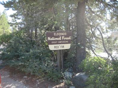
REDI,LOON LAKE RED FIR,Crystal Basin,Icehouse Road,Loon Lake,ELDORADO NF – FS

Related Link(s)

Rec Area Info & Images

California State Tourism

California State Road Conditions

Overview

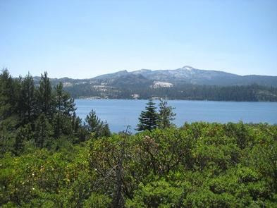
Situated on the north side of the Loon Lake Reservoir, Red Fir Group Campground offers a primitive group camping experience in the lush Eldorado National Forest.

Recreation

The nearby lake provides fishing, swimming and boating, and the campground is just a short walk across the road to the water’s edge.

Visitors also enjoy off-road vehicle and motorcycle riding on the popular Rubicon Jeep trail.

Hiking and wilderness backpacking are popular activities. Day permits are available at the nearby Loon Lake trailhead and overnight permits are available at the Eldorado Information Center.

Facilities

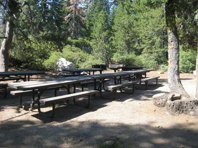
The campground offers tent-only campsites, accommodating a group of up to 25 guests.

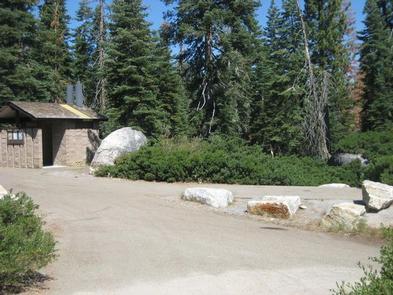
A group kitchen area is equipped with multiple tables, a campfire circle and grills. Accessible vault toilets and drinking water are provided.

Natural Features

The campground is part of the Crystal Basin Recreation Area, situated at a 6,400-foot elevation and nestled in a forest of tall pine trees.

Nearby Attractions

The campground is not far from the Desolation Wilderness.

Reservation

More from CampingHiking.net:

WOODRING CAMPGROUND, Georgia Campground Images, Info & Reservations

Listen Directions From Atlanta, take I-75 north to Exit 293; follow Highway 411 north. Turn right on Highway 136, then left on old Highway 411. Turn right on Highway 282/76. Campground is located 4.5 miles off Highway 282. From Ellijay, GA, take Highway 282/76 west for 11 miles to the

BEARD’S BLUFF PARK (AR), Arkansas Campground Images, Info & Reservations

Listen Directions Beard’s Bluff Park is located 13 miles east of Ashdown on State Highway 32. When driving from Ashdown, cross Millwood Dam and take the second left. Phone 870-388-9556 Activities BOATING, CAMPING, FISHING, WILDLIFE VIEWING Keywords Related Link(s) Rec Area Info & Images Arkansas State Tourism Arkansas State Road

FREMONT CAMPGROUND, California Campground Images, Info & Reservations

Listen Directions From Santa Barbara, take Highway 154 approximately 9 miles to Paradise Road. Turn right and follow the road to the campground. Phone 805-434-1996 Activities BIKING, BOATING, CAMPING, FISHING, HORSEBACK RIDING, SWIMMING SITE Keywords FRCA,Fremont Park,Fremont Recreation Area,LOS PADRES NF -FS Related Link(s) Rec Area Info & Images California

LONESOMEHURST CAMPGROUND, Montana Campground Images, Info & Reservations

Listen Directions From West Yellowstone, travel west on Highway 20 for eight miles, then continue four miles north on Hebgen Lake Road (Denny Creek Road). Phone 406-646-1012 Activities BIKING, BOATING, CAMPING, FISHING, HIKING, WILDLIFE VIEWING, PHOTOGRAPHY, SWIMMING, KAYAKING, CANOEING, BERRY PICKING, STAR GAZING, BIRDING, WATER ACCESS, BACKPACKING Keywords None Related

MALLARD MARSH CAMPGROUND, Oregon Campground Images, Info & Reservations

Listen Directions From Bend, travel 35.5 miles southwest on Cascade Lakes Hwy (46), then 1.3 miles east on Forest Road 4625. South Campground will come up on the right side first and then Mallard Marsh. Phone 541-323-1746 Activities CAMPING Keywords Related Link(s) Rec Area Info & Images Oregon State Tourism