NORTH DAVIS CREEK CAMPGROUND, Oregon Campground Reservation, Info, Images, Map, Directions

NORTH DAVIS CREEK CAMPGROUND, Oregon Campground Images, Info & Reservations

Listen

Directions

From Bend, OR: Travel 56.2 miles southwest on Cascade Lakes Hwy (46). The campground is on the east side of the highway.

Phone

541-323-1746

Activities

CAMPING

Keywords

Related Link(s)

Rec Area Info & Images

Oregon State Road Conditions

Oregon State Tourism

Overview

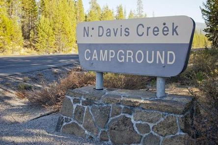
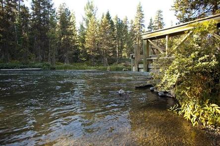
North Davis Creek Campground is located on the western arm of Wickiup Reservoir at the connection to North Davis Creek. This facility offers opportunities for wildlife viewing, as well as access, to Wickiup Reservoir and fishing.

Recreation

Wickiup Reservoir’s relatively warm water and cooler deep channels generate opportunities for fishing. The area is renowned for its brown trout, as well as kokanee and Coho salmon, rainbow trout, brook trout, whitefish and chub. Visitors also enjoy boating, canoeing and swimming.

Facilities

North Davis Creek Campground can accommodate RV, trailer or tent-campers, however, water and electric hookups are not available. All sites are equipped with a picnic table and campfire ring with grill and the campground has vault toilets and drinking water available.

Natural Features

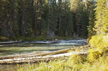
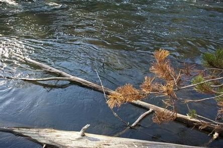
Located on Wickiup Reservoir, North Davis Creek Campground sits beneath a mixed conifer canopy near remnants of past lava flows.

Nearby Attractions

Visitors can explore wilderness areas, rivers, lakes and reservoirs, and approximately hundred of miles of trail. Newberry National Volcanic Monument, approxiately 45 minutes by vehicle, is a great starting point for visitors to learn about the diverse landscape and history of the area through interpretive programs and exhibits. Visitors can explore Lava River Cave, the longest continuous lava tube in Oregon. Visitors enjoy traveling the Cascade Lakes Scenic Bywaywhich climbs 66 miles through the Cascade Range, weaving past snow-capped peaks and alpine lakes.

Reservation

More from CampingHiking.net:

UP UP LOOKOUT, Montana Campground Images, Info & Reservations

Listen Directions West bound on I-90 take the Drexel Exit #25. From Drexel turn back east on I-90 to Ward Creek Exit #26. East bound on I-90 take the Ward Cr Exit #26. Proceed up the Ward Creek Rd #889, travel 3.2 miles. Turn right onto Road #3816 and travel

TILLIE CREEK, California Campground Images, Info & Reservations

Listen Directions From Bakersfield, California, take Highway 178 east to the town of Lake Isabella. From Lake Isabella take Highway 155 north, traveling 6 miles to the entry station of Tillie Creek Campground. Phone 760-376-1815 Activities BOATING, CAMPING Keywords TILL,LAKE ISABELLA,KERN VALLEY,SEQUOIA NF – FS Related Link(s) Rec Area Info

CHIPPEWA LOOP, Minnesota Campground Images, Info & Reservations

Listen Directions From Cass Lake, Minn., take U.S. Highway 2 east for 4 miles, to the Norway Beach Recreation Area. Turn left and follow the campground road until the signs indicate the Chippewa Loop. Phone 218-335-8600 Activities BIKING, BOATING, HISTORIC & CULTURAL SITE, CAMPING, INTERPRETIVE PROGRAMS, FISHING, WATER SPORTS, SWIMMING

HORSE CREEK PAVILION, Tennessee Campground Images, Info & Reservations

Listen Directions From Greeneville, take TN 107 north for six miles. Turn right at Horse Creek Road and follow the signs for about two miles to the recreation area. Phone (423)638-4109 Activities CAMPING, FISHING, HIKING, PICNICKING, WILDERNESS, FISH VIEWING SITE, DAY USE AREA, WATER ACTIVITIES, BIRDING, WATER ACCESS, BACKPACKING Keywords