BLUFF VIEW(CLEARWATER LAKE), MO Campground Reservation, Info, Images, Map, Directions

BLUFF VIEW(CLEARWATER LAKE), Missouri Campground Images, Info & Reservations

Listen

Directions

The campground is located 7 miles northwest of Piedmont, MO. From Piedmont on Highway 49, go 1 mile to Highway AA and turn left. Drive 6 miles on Highway AA, and the road will end in Bluff View Park.

Phone

573-223-7777 (CLEARWATER PROJECT OFFICE) 573-223-4459 (BLUFF VIEW GATEHOUSE)

Activities

BOATING, CAMPING, FISHING, SWIMMING SITE

Keywords

BLU2,CLEARWATER LAKE,BLUFF VIEW CLEARWATER LAKE,CLEARWATER LAKE

Related Link(s)

Rec Area Info & Images

Missouri State Tourism

Missouri State Road Conditions

Overview

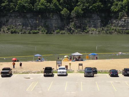
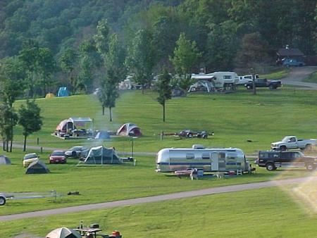
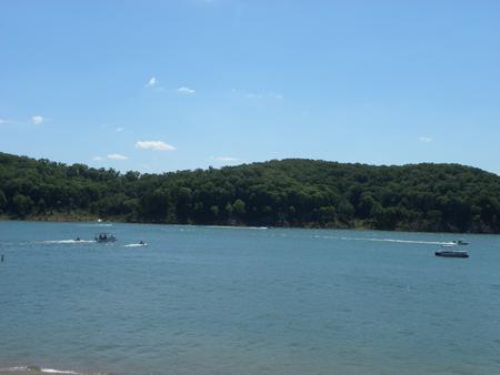
Bluff View Campground on Clearwater Lake greets visitors with excellent camping, fishing, swimming, boating and picnicking opportunities.

Local wildlife includes wetland waterfowl, fox, deer, turkey, and geese. Bald eagles nest at Clearwater, and remain in the area year-round.

Recreation

A trailhead for the Bluff View Nature Trail begins at the campground. This is a wonderful loop trail to look for wildlife among a mix of towering hardwood trees.

Facilities

Bluff View Campground offers 60 sites, including many with electric and water hookups. Additional amenities include a dump station, hot showers, boat ramp, playground, interpretive trail, public phones and a swimming area.

Natural Features

The lake, surrounded by the picturesque hills of the Ozarks, is fed by the Black River. Average temperatures range from 33 to 59 degrees Fahrenheit in March, and 65 to 92 degrees in summer.

Nearby Attractions

In the area, campers enjoy visiting traditional drive-in movie theaters, the Sam A. Baker State Park, local golf courses, and the historic Civil War site at Fort Benton.

Reservation

More from CampingHiking.net:

GIRARD RIDGE LOOKOUT, California Campground Images, Info & Reservations

Listen Directions From Redding California, or Mt. Shasta, take Interstate 5 towards Castle Crags State Park. Exit the Interstate at the Soda Creek exit 726. From here, the lookout is approximately 7.5 miles over mostly dirt road. Head east towards the Sacramento River. Cross the bridge over the river and

SNAKE CREEK, Oklahoma Campground Images, Info & Reservations

Listen Directions From Gore, OK, go 15 miles northeast on Highway 100, then turn left and go 1/2 mile west on paved access road. Phone 918-487-5252 Activities BOATING, CAMPING, SWIMMING SITE Keywords SANK,TENKILLER LAKE,TENKILLER FERRY LAKE,TENKILLER FERRY Related Link(s) Rec Area Info & Images Oklahoma State Road Conditions Oklahoma State

GREEN VALLEY, California Campground Images, Info & Reservations

Listen Directions From Running Springs, travel east on Highway 18 about 3 miles to Green Valley Lake Road. Turn left and continue about 6 miles to the campground. Phone 909-866-8550 Activities BOATING, CAMPING, FISHING, HIKING, SWIMMING SITE Keywords GREV,GREEN VALLEY San Bernardino,SAN BERNARDINO NF – FS Related Link(s) Rec Area

RIVERSIDE (KS), Kansas Campground Images, Info & Reservations

Listen Directions From Salina, KS: Take HWY 140 19 miles west to HWY 141. Travel 14 miles south on 141, then 1/2 mile east on Riverside Drive. Look for signs to the park. From Ellsworth, KS: Take HWY 140 15 miles east to HWY 141. Travel 14 miles South on

PIONEER TRAIL, California Campground Images, Info & Reservations

Listen Directions From Sonora, California, take Highway 108 east for about 30 miles. Exit at Pinecrest Lake and turn right on Dodge Ridge Road. Continue 1 mile to Pioneer Trails Campground, located on the left. Phone 209-965-3474 Activities BOATING, CAMPING, FISHING, HIKING, SWIMMING SITE Keywords PION,STANISLAUS NF -FS Related Link(s)